Liebenwalde
From Wikipedia, the free encyclopedia
Liebenwalde | |
|---|---|
 Kreuzbruch church | |
 Coat of arms | |
Location of Liebenwalde within Oberhavel district 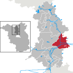 | |
 Liebenwalde  Liebenwalde | |
| Coordinates: 52°52′N 13°24′E / 52.867°N 13.400°E | |
| Country | Germany |
| State | Brandenburg |
| District | Oberhavel |
| Subdivisions | 6 districts |
| Government | |
| • Mayor (2019–27) | Jörn Lehmann[1] |
| Area | |
• Total | 142.17 km2 (54.89 sq mi) |
| Elevation | 41 m (135 ft) |
| Population (2023-12-31)[2] | |
• Total | 4,445 |
| • Density | 31.27/km2 (80.98/sq mi) |
| Time zone | UTC+01:00 (CET) |
| • Summer (DST) | UTC+02:00 (CEST) |
| Postal codes | 16559 |
| Dialling codes | 033054 |
| Vehicle registration | OHV |
| Website | www.liebenwalde.de |
Liebenwalde (German pronunciation: [ˌliːbn̩ˈvaldə] ⓘ) is a town in the Oberhavel district, in Brandenburg, in north-eastern Germany. It is situated 16 km (10 mi) northeast of Oranienburg, and 39 km (24 mi) north of Berlin (centre).