Nagarzê County
County in Tibet, China
From Wikipedia, the free encyclopedia
Nagarzê County (Tibetan: སྣ་དཀར་རྩེ་རྫོང་།, Chinese: 浪卡子县) is a county of Shannan located in the south-east of the Tibet Autonomous Region, China. The Yarlung Tsangpo river dominates the county. Baidi Township is located in the county.

Nagarzê County
浪卡子县 • སྣ་དཀར་རྩེ་རྫོང་། | |
|---|---|
| |
 Nagarzê Location of the seat in Tibet  Nagarzê Nagarzê (China) | |
| Coordinates: 28°51′03″N 90°55′21″E | |
| Country | China |
| Autonomous region | Tibet |
| Prefecture-level city | Shannan (Lhoka) |
| County seat | Nagarzê |
| Area | |
• Total | 7,969.89 km2 (3,077.19 sq mi) |
| Elevation | 4,300–5,000 m (14,100–16,400 ft) |
| Population | |
• Total | 32,835 |
| • Density | 4.1199/km2 (10.670/sq mi) |
| Time zone | UTC+8 (China Standard) |
| Website | www |
| Nagarzê County | |||||||
|---|---|---|---|---|---|---|---|
| Chinese name | |||||||
| Simplified Chinese | 浪卡子县 | ||||||
| Traditional Chinese | 浪卡子縣 | ||||||
| |||||||
| Tibetan name | |||||||
| Tibetan | སྣ་དཀར་རྩེ་རྫོང་། | ||||||
| |||||||
History
Historically, the area governed by Nagarzê County was collectively known as "Yangzho" (Tibetan: ཡངས་འབྲོག་, meaning "Upper Pasture").[2]
During the Tang Dynasty (618-907 CE), when the 32nd Tibetan King Songtsen Gampo established the Tibetan Empire, this region was incorporated into the military-administrative division "Yoru" (约茹) and named "Yangzho Kangqing Buren Di Ayu" (Tibetan: ཡངས་འབྲོག་ཁང་ཆེན་བུ་རིན་དི་ཨ་ཡུལ་), meaning "The Five Yak-Nurturing Homelands in the Snowy Upper Pasture". In the Yuan Dynasty (1271-1368), the central government appointed leaders of the Sakya school of Tibetan Buddhism to administer Tibet, establishing the Yangzho Ten-thousand Household Office (羊卓万户府) within Nagarzê's jurisdiction.[3]
During the Ming Dynasty (1368-1644), the Phagmodrupa regime (Chinese: 帕竹政权), supported by the Ming court, established Nagarzê Dzong (浪卡子宗) to govern the Yangzho region.[4]
In 1954, the Tibetan local government divided the area into three administrative units: Nagarzê Dzong, Baid Dzong (白地宗), and Daglung Dzong (打隆宗), all under the jurisdiction of Lhoka Gigu (洛喀基巧, Governor of Southern Tibet). Following democratic reforms in 1959, the Preparatory Committee of the Tibet Autonomous Region merged Langdzê Dzong (朗格则宗) and Baid Dzong into Nagarzê County, while establishing Daglung County (打隆县) through the merger of Daglung and Linggu (岭谷), both placed under Gyantse Prefecture (江孜专区).[5] In February 1964, Daglung County was incorporated into Nagarzê County and transferred to Lhoka Prefecture (山南专区), where it remains administratively today.[6]
Administrative divisions
Nagarzê County contains 2 towns and 8 townships.
| Name | Chinese | Hanyu Pinyin | Tibetan | Wylie |
|---|---|---|---|---|
| Towns | ||||
| Nagarzê Town | 浪卡子镇 | Làngkǎzǐ zhèn | སྣ་དཀར་རྩེ་གྲོང་རྡལ། | sna dkar rtse grong rdal |
| Daglung Town | 打隆镇 | Dǎlóng zhèn | སྟག་ལུང་གྲོང་རྡལ། | stag lung grong rdal |
| Townships | ||||
| Chamda Township | 张达乡 | Zhāngdá xiāng | གྲམ་མདའ་ཤང་། | gram mda' shang |
| Lhülpozhöl Township | 伦布雪乡 | Lúnbùxuě xiāng | ལྷུན་པོ་ཞོལ་ཤང་། | lhun po zhol shang |
| Doqoi Township | 多却乡 | Duōquè xiāng | མདོ་ཆོས་ཤང་། | mdo chos shang |
| Puma Jangtang Township | 普玛江塘乡 | Pǔmǎjiāngtáng xiāng | ཕུ་མ་བྱང་ཐང་ཤང་། | phu ma byang thang shang |
| Ngardrak Township | 阿扎乡 | Āzhā xiāng | མངར་བྲག་ཤང་། | mngar brag shang |
| Karlung Township | 卡龙乡 | Kǎlóng xiāng | མཁར་ལུང་ཤང་། | mkhar lung shang |
| Baidi Township | 白地乡 | Báidì xiāng | དབལ་དི་ཤང་། | dpal di shang |
| Karrêg Township | 卡热乡 | Kǎrè xiāng | ཁ་དབྲག་ཤང་། | kha dbrag shang |
Climate
| Climate data for Nagarzê, elevation 4,432 m (14,541 ft), (1991–2020 normals) | |||||||||||||
|---|---|---|---|---|---|---|---|---|---|---|---|---|---|
| Month | Jan | Feb | Mar | Apr | May | Jun | Jul | Aug | Sep | Oct | Nov | Dec | Year |
| Mean daily maximum °C (°F) | 2.7 (36.9) |
4.0 (39.2) |
6.6 (43.9) |
9.7 (49.5) |
13.3 (55.9) |
16.6 (61.9) |
16.1 (61.0) |
15.4 (59.7) |
14.1 (57.4) |
11.4 (52.5) |
7.3 (45.1) |
4.6 (40.3) |
10.2 (50.3) |
| Daily mean °C (°F) | −4.3 (24.3) |
−2.8 (27.0) |
−0.1 (31.8) |
2.7 (36.9) |
6.4 (43.5) |
10.1 (50.2) |
10.4 (50.7) |
9.8 (49.6) |
8.0 (46.4) |
4.0 (39.2) |
−0.2 (31.6) |
−2.7 (27.1) |
3.4 (38.2) |
| Mean daily minimum °C (°F) | −11.2 (11.8) |
−9.8 (14.4) |
−6.4 (20.5) |
−3.3 (26.1) |
0.2 (32.4) |
4.3 (39.7) |
6.1 (43.0) |
5.6 (42.1) |
2.9 (37.2) |
−2.5 (27.5) |
−6.9 (19.6) |
−9.5 (14.9) |
−2.5 (27.4) |
| Average precipitation mm (inches) | 0.4 (0.02) |
0.9 (0.04) |
2.7 (0.11) |
9.0 (0.35) |
22.3 (0.88) |
49.9 (1.96) |
122.0 (4.80) |
119.3 (4.70) |
50.8 (2.00) |
7.7 (0.30) |
1.3 (0.05) |
0.6 (0.02) |
386.9 (15.23) |
| Average precipitation days (≥ 0.1 mm) | 0.5 | 0.9 | 2.7 | 5.8 | 8.7 | 14.4 | 21.5 | 22.2 | 15.4 | 3.1 | 0.8 | 0.3 | 96.3 |
| Average snowy days | 2.1 | 3.8 | 6.9 | 11.3 | 11.3 | 1.1 | 0.1 | 0.2 | 1.2 | 4.6 | 2.1 | 1.4 | 46.1 |
| Average relative humidity (%) | 23 | 25 | 31 | 40 | 48 | 57 | 68 | 71 | 67 | 47 | 30 | 23 | 44 |
| Mean monthly sunshine hours | 258.8 | 235.0 | 257.7 | 250.7 | 257.2 | 228.5 | 179.5 | 176.0 | 204.1 | 267.8 | 272.3 | 269.3 | 2,856.9 |
| Percentage possible sunshine | 79 | 74 | 69 | 65 | 61 | 55 | 42 | 44 | 56 | 76 | 86 | 85 | 66 |
| Source: China Meteorological Administration[7][8] | |||||||||||||
Gallery
 Lake at Sim La
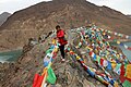 Sim La 4330m
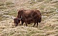 Yak
Yak Karo La-Glacier
 Karo La 5030m
 Sheep
Sheep Yamdrok Tso
 Yamdrok Lake (labelled as YAMDROG TSHO) (1954)


