Statenville, Georgia
Place in Georgia, United States
From Wikipedia, the free encyclopedia
Statenville is an unincorporated community in and the county seat of Echols County, Georgia, United States.[1] It was formerly a census-designated place (CDP) with a population of 1,040 at the 2010 census.[2] The ZIP code is 31648, and the area code 229.

Statenville, Georgia | |
|---|---|
Echols County Courthouse in Statenville | |
 Statenville Location within the state of Georgia  Statenville Statenville (the United States) | |
| Coordinates: 30°42′11″N 83°1′40″W | |
| Country | United States |
| State | Georgia |
| County | Echols |
| Area | |
• Total | 4.6 sq mi (12.0 km2) |
| • Land | 4.6 sq mi (12.0 km2) |
| • Water | 0 sq mi (0.0 km2) |
| Elevation | 138 ft (42 m) |
| Population (2010) | |
• Total | 1,040 |
| • Density | 230/sq mi (87/km2) |
| Time zone | UTC-5 (Eastern (EST)) |
| • Summer (DST) | UTC-4 (EDT) |
| ZIP code | 31648 |
| Area code | 229 |
| FIPS code | 13-73200 |
| GNIS feature ID | 356558 |
History
The town of Statenville was originally called Troublesome. It grew up at a ford on the Alapaha River in the 1850s. Troublesome was renamed Statenville when the latter was designated county seat in 1858 of the newly-formed Echols County. It is named for James Watson Staten,[3] but was erroneously incorporated as "Statesville" in 1859.[4] In 1965, the state officially amended the city's charter to read "Statenville". In 1995, a new state law revoked the city charter, along with dozens of others in Georgia which had inactive governments. This left Echols and Webster as the only counties in Georgia with no incorporated communities.
In July 2008, a referendum passed to consolidate the city with Echols County by a margin of 639 to 245.[5]
Geography
Statenville is located in western Echols County, just east of the Alapaha River. U.S. Route 129 passes through the community, leading north 27 miles (43 km) to Lakeland, south 6 miles (10 km) to the Florida border, and south 14 miles (23 km) to Jasper, Florida. Georgia State Route 94 crosses US 129 in the center of Statenville, leading east 28 miles (45 km) to Fargo and northwest 18 miles (29 km) to Valdosta.
According to the U.S. Census Bureau, the Statenville CDP has a total area of 11.96 square kilometres (4.62 sq mi), all land.[2]
Education
The Echols County School District consists of two schools.[6] The district has 40 full-time teachers and over 700 students.[7]
The South Georgia Regional Library operates the Hansford Allen Echols County Library. Named after timber and turpentine farmer Handsford Allen, who contributed money towards the establishment of the library, it is the smallest library in the system. It opened on July 19, 1992, with its construction funded by State of Georgia money. The community previously had its library in other locations: first in a Methodist church and later in the school district superintendent's courthouse office.[8]
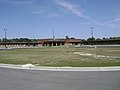 Echols County Schools
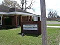 Hansford Allen Echols County Library


Demographics
Statenville appeared as a census designated place in the 2010 U.S. census.[21] It no longer was listed thereafter due to consolidation with the county in 2008.[22]
| Race / Ethnicity (NH = Non-Hispanic) | Pop 2010[23] | % 2010 |
|---|---|---|
| White alone (NH) | 560 | 53.85% |
| Black or African American alone (NH) | 121 | 11.63% |
| Native American or Alaska Native alone (NH) | 22 | 2.12% |
| Asian alone (NH) | 9 | 0.87% |
| Pacific Islander alone (NH) | 1 | 0.10% |
| Some Other Race alone (NH) | 0 | 0.00% |
| Mixed Race/Multi-Racial (NH) | 23 | 2.21% |
| Hispanic or Latino (any race) | 304 | 29.23% |
| Total | 1,040 | 100.00% |