's-Gravendeel
Village in South Holland, Netherlands
From Wikipedia, the free encyclopedia
's-Gravendeel (Dutch pronunciation: [ËsxraËvÉ(n)ËdeËl] â) is a village and former municipality in the western Netherlands, in the province of South Holland. 's-Gravendeel is on the eastern side of Hoeksche Waard Island on the river Dordtsche Kil. It is connected to Dordrecht by means of the Kil Tunnel.
's-Gravendeel | |
|---|---|
Village | |
 Dutch Reformed church | |
 's-Gravendeel Location in the province of South Holland in the Netherlands  's-Gravendeel Location in the Netherlands | |
| Coordinates: 51°47â²N 4°37â²E | |
| Country | Netherlands |
| Province | South Holland |
| Municipality | Hoeksche Waard |
| Area | |
⢠Total | 20.70 km2 (7.99 sq mi) |
| Elevation | 0.2 m (0.66 ft) |
| Population (2021)[1] | |
⢠Total | 9,000 |
| ⢠Density | 430/km2 (1,100/sq mi) |
| Time zone | UTC+1 (CET) |
| ⢠Summer (DST) | UTC+2 (CEST) |
| Postal code | 3295[1] |
| Dialing code | 078 |
The village was first mentioned in 1645 as Schravendeel, and means "settlement of the Count (of Holland)".[3] The village was founded after the new polder Nieuw-Bonaventura was drained in 1593.[3] It used to be property of the States of Holland. In 1731, the village was sold to Dordrecht.[4] 's-Gravendeel developed into the centre of the flax industry.[5]
The Dutch Reformed church is a cruciform church built in 1905 after the 1637 church had burnt down. The tower was destroyed in 1945 and rebuilt in 1951.[5]
's-Gravendeel was home to 928 people in 1840.[4] It was affected by the North Sea flood of 1953. In 1970, the old harbour was filled up and a new harbour was built on the Dordtsche Kil.[5]
The municipality of 's-Gravendeel was merged with Binnenmaas on 1 January 2007. Since 1 January 2019, it is part of the new municipality Hoeksche Waard.[6]
Gallery
 Windmill: korenmolen het Vliegend Hert
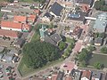 Reformed church in 's-Gravendeel with its notable church moat

