's-Gravenpolder
Village in Zeeland, Netherlands
From Wikipedia, the free encyclopedia
's-Gravenpolder is a village in the Dutch province of Zeeland. It is a part of the municipality of Borsele, and lies about 21 kilometres east of Middelburg.
_(1).JPG)
's-Gravenpolder | |
|---|---|
Village | |
St Martinus Church | |
 Flag  Coat of arms | |
  's-Gravenpolder Location in the province of Zeeland in the Netherlands  's-Gravenpolder 's-Gravenpolder (Netherlands) | |
| Coordinates: 51°27â²35â³N 3°54â²12â³E | |
| Country | Netherlands |
| Province | Zeeland |
| Municipality | Borsele |
| Area | |
⢠Total | 8.00 km2 (3.09 sq mi) |
| Elevation | 1.0 m (3.3 ft) |
| Population (2021)[1] | |
⢠Total | 4,690 |
| ⢠Density | 586/km2 (1,520/sq mi) |
| Time zone | UTC+1 (CET) |
| ⢠Summer (DST) | UTC+2 (CEST) |
| Postal code | 4431[1] |
| Dialing code | 0113 |
History
The village was first mentioned in 1318 as "dat Nuweland van Vortrap", and means "polder of the Count". Before 1316, William III, Count of Holland ordered the construction of a dike around Voortrappen. It was first called 's-Gravenpolder in 1386.[3] The polder and village were owned by the Count of Holland until 1430. 's-Gravenpolder developed as a linear road village.[4]
The Dutch Reformed church is a Gothic cruciform church with built-in tower. The choir probably dates from the late-14th century. The tower and nave were constructed in the early-15th century.[4] It was severely damaged during World War II.[5] During the renovation of 1959 to 1961, the plaster was removed and the current spire was built.[4]
The grist mill De Korenhalm was built in 1876. An electro motor was installed in a shed near the wind mill. Since 1992, it is owned by a foundation and still in service.[6]
's-Gravenpolder was home to 577 people in 1840.[5] In 1927, a joint railway station with 's-Heer Abtskerke opened on the Goes to Hoedekenskerke. It closed in 1947.[7] The village was severely damaged during World War II.[4] 's-Gravenpolder was a separate municipality until 1970 when it merged into Borsele.[8]
Gallery
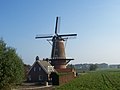 Wind mill De Korenhalm
 Former railway station

