Interstate 80 in California
From Wikipedia, the free encyclopedia
Interstate 80 (I-80) is a transcontinental Interstate Highway in the United States, stretching from San Francisco, California, to Teaneck, New Jersey. The segment of I-80 in California runs east from San Francisco across the San Francisco–Oakland Bay Bridge to Oakland, where it turns north and crosses the Carquinez Bridge before turning back northeast through the Sacramento Valley. I-80 then traverses the Sierra Nevada, cresting at Donner Summit, before crossing into the state of Nevada within the Truckee River Canyon. The speed limit is at most 65 mph (105 km/h) along the entire route instead of the state's maximum of 70 mph (110 km/h) as most of the route is in either urban areas or mountainous terrain. I-80 has portions designated as the Eastshore Freeway and Alan S. Hart Freeway.
.svg)
Interstate 80 | ||||
|---|---|---|---|---|
| Dwight D. Eisenhower Highway | ||||
 I-80 highlighted in red | ||||
| Route information | ||||
| Maintained by Caltrans | ||||
| Length | 205.07 mi[1][2] (330.03 km) | |||
| Existed | July 1, 1964[3]–present | |||
| Tourist routes | ||||
| NHS | Entire route | |||
| Restrictions | No flammable tank vehicles or explosives on the Bay Bridge[4] | |||
| Major junctions | ||||
| West end | ||||
| East end | ||||
| Location | ||||
| Country | United States | |||
| State | California | |||
| Counties | San Francisco, Alameda, Contra Costa, Solano, Napa, Yolo, Sacramento, Placer, Nevada, Sierra | |||
| Highway system | ||||
| ||||
Throughout California, I-80 was built along the corridor of US Route 40 (US 40), eventually replacing this designation entirely. The prior US 40 corridor itself was built along several historic corridors in California, notably the California Trail and Lincoln Highway. The route has changed from the original plans in San Francisco due to freeway revolts canceling segments of the originally planned alignment. Similarly in Sacramento, the freeway was rerouted around the city after plans to upgrade the original grandfathered route through the city to Interstate Highway standards were canceled.
Route description
The entirety of Interstate 80 in California is defined in section 380 of the California Streets and Highways Code as Route 80:[5]
Route 80 is from:
(a) Route 101 near Division Street in San Francisco to Route 280 near First Street in San Francisco.
(b) Route 280 near First Street in San Francisco to the Nevada state line near Verdi, Nevada, passing near Oakland, via Albany, via Sacramento, passing near Roseville, via Auburn, via Emigrant Gap, via Truckee and via the Truckee River Canyon.
The section of Route 80 defined in subdivision (a) is not considered an Interstate Highway according to the Federal Highway Administration (FHWA)'s route logs,[1] but is still signed as I-80 by Caltrans.
I-80 is recognized as the Dwight D. Eisenhower Highway in the Western United States and a Blue Star Memorial Highway for its entire length. In California, it follows the original corridor of the Lincoln Highway from Sacramento to Reno (with minor deviations near Donner Summit). I-80 is part of the California Freeway and Expressway System[6] and is part of the National Highway System,[7] a network of highways that are considered essential to the country's economy, defense, and mobility by the Federal Highway Administration (FHWA).[8] I-80 is also known as the Dutch Flat and Donner Lake Wagon Road from Emigrant Gap to Donner Lake.[9] The segment of I-80 from Emigrant Gap to Truckee also forms part of the Yuba–Donner Scenic Byway, a National Forest Scenic Byway.[10]
San Francisco Bay Area

According to the California Streets and Highways Code, most maps, and local signs, I-80 begins at the interchange with US 101 in San Francisco. However, federal records place the western terminus of I-80 at the western approach to the San Francisco–Oakland Bay Bridge, at the location of the Fremont Street offramp (previously known as the Terminal Separator Structure that once connected it to the Embarcadero Freeway).[11][12] The federal and state governments disagree as to whether this westernmost segment of the signed Interstate, known as the San Francisco Skyway or Bayshore Viaduct, is actually part of the Interstate Highway System,[11][12] although it is consistently shown as I-80 on most maps of San Francisco.[12]
Eastshore Freeway
The Eastshore Freeway is a segment of I-80 and I-580 along the northeast shoreline of San Francisco Bay. It runs from the MacArthur Maze interchange just east of the eastern end of the San Francisco–Oakland Bay Bridge to the Carquinez Bridge. I-580 splits from the Eastshore Freeway at an interchange known locally as the "Hoffman Split" in Albany. The section of the Eastshore Freeway between the MacArthur Maze and I-580 (Hoffman) split between Albany is a wrong-way concurrency where the northbound direction is signed as I-80 east and I-580 west, while the southbound direction is signed as westbound I-80 and eastbound I-580. This segment suffers from severe traffic congestion during rush hour due to the merger of three freeways (I-80, I-580, and I-880) at the MacArthur Maze.

The Eastshore Freeway was created in the mid-1950s[13] (construction commenced in 1954, last segment completed May 10, 1960[14]) by reengineering the Eastshore Highway, a thoroughfare constructed in the 1930s (1934–1937) as one of the approaches to the Bay Bridge and designated as part of US 40.[15] The Eastshore Highway began in El Cerrito at an intersection with San Pablo Avenue at Hill Street between Potrero Avenue and Cutting Boulevard,[16] adjacent to the location today of the El Cerrito del Norte station of Bay Area Rapid Transit (BART). It was not a freeway in that access was at intersections with adjoining streets rather than by ramps. The Eastshore Highway ran from El Cerrito to the San Francisco–Oakland Bay Bridge along the same routing as today's freeway, although it was much narrower. A causeway was constructed for this purpose by filling in part of the mudflats along the bayshore. In the stretch from University to Ashby avenues in Berkeley, this resulted in the creation of an artificial lagoon which was developed by the Works Progress Administration (WPA) in the late 1930s as Aquatic Park.
The frontage road along the east side of today's Eastshore Freeway between Buchanan Street in Albany and Hearst Avenue in Berkeley retains the name "Eastshore Highway". The terminal segment of the old Eastshore Highway in El Cerrito between Potrero and San Pablo avenues is today named "Eastshore Boulevard".
Originally, the name "Eastshore Freeway" was also applied to what is today known as the "Nimitz Freeway" (I-880) from the beginning of its construction in 1947. This freeway was dedicated in 1958 to Chester W. Nimitz, and so, for a few years in the 1950s prior, the Eastshore Freeway stretched the entire length of the east shore of San Francisco Bay.[17][18] Until the late 1960s, the Eastshore Freeway was also designated as part of State Route 17 (SR 17) together with the Nimitz Freeway.[19]
Central Valley

This section of I-80 has a top speed of 65 mph (105 km/h), unlike California's top speed limit of 70 mph (110 km/h), common in rural freeways.[20] I-80 is a six- to eight-lane freeway with carpool lanes in Fairfield between exit 39A (Red Top Road) and exit 47 (Air Base Parkway).[21]
I-80 has changed routing in the Sacramento area. Currently, the freeway runs on a northern bypass of the city, the Beltline Freeway, that was originally designated I-880. The I-80 routing alignment was moved from a route through Sacramento, now US 50 and I-80 Business (I-80 Bus), after the proposed I-80 replacement of the North Sacramento Freeway was canceled. The Beltline Freeway runs northeast from the junction of I-80 and US 50 in West Sacramento across I-5 to its junction northeast of Sacramento with I-80 Bus (which is SR 51). SR 244 heads east as a short freeway spur from that interchange.
Sierra Nevada
Crossing the Sierra Nevada, I-80 regularly gets snow at higher elevations from fall to spring. The California Department of Transportation (Caltrans) sometimes requires vehicles to use snow tires, snow chains, or other traction devices in the mountains during and after snowstorms. Checkpoints are often set up to enforce chain restrictions on vehicles bound for icy or snowy areas. When chain restrictions are in effect, vehicles must have chains on the driving wheels, except 4WD vehicles with snow tires. Additionally, during the winter season, trucks are required to carry chains whether or not controls are in force.[22][23]
I-80 crosses the Sierra Nevada crest at Donner Summit (also known as Euer Saddle) at an elevation of 7,239 feet (2,206 m) westbound and 7,227 feet (2,203 m) eastbound. The Donner Summit Rest Area is located at this point.[24][25] The summit is located in Nevada County, California. The pass is generally open year-round; it is plowed in winter but may temporarily close during the worst snowstorms. The older, original US 40/Lincoln Highway route over Donner Pass is about two miles (3.2 km) to the south. This highway was replaced as the official trans-Sierra route by I-80 in 1964. Although the current Donner Pass is lower, Euer Saddle was chosen for the Interstate because of more gradual approaches that aided construction to Interstate Highway standards, which do not allow the sharp curves used by the Donner Pass Road. The grade is three to six percent for 30 miles (48 km).[26]
- I-80 across the Sierra Nevada
 Looking northeast along I-80 in the Sierra Nevada from the Yuba Gap overpass
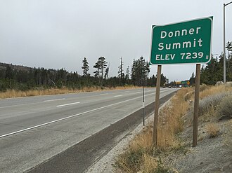 Sign for Donner Summit
 Entering California from Nevada along I-80
 Elevations along a 100-mile (160 km) stretch of the I-80, peaking at Donner saddle


Tolls
San Francisco–Oakland Bay Bridge
Tolls are collected only for westbound traffic on the San Francisco–Oakland Bay Bridge's eastern span headed to Yerba Buena Island (those just traveling on the bridge's western span between Yerba Buena Island and the main part of San Francisco are not tolled). All-electronic tolling is used on the bridge, and they can be paid by either a FasTrak transponder or license plate tolling. The high-occupancy vehicle (HOV) lane leading to the bridge requires a car with three or more people.[27]
Carquinez Bridge
Tolls are collected only for eastbound traffic on the Carquinez Bridge headed to Vallejo. All-electronic tolling is also used on this bridge, and they can be paid by either a FasTrak transponder or license plate tolling. The high-occupancy vehicle (HOV) lane leading to the bridge requires a car with three or more people.[28]
Express lanes
High-occupancy toll (HOT) lanes along the 18-mile (29 km) segment of I-80 between Red Top Road in Fairfield and Leisure Town Road in Vacaville opened on December 16, 2025.[29] Construction on them began in May 2022, and included converting the existing 8-mile (13 km) carpool lanes between Red Top Road and Air Base Parkway.[21][30]
As of January 2026[update], the HOT lanes' hours of operation is weekdays between 5:00 am and 8:00 pm; they are otherwise free and open to all vehicles at other times. Solo drivers are tolled using a congestion pricing system based on the real-time levels of traffic. Two-person carpools are charged 50 percent of the posted toll. Carpools with three or more people and motorcycles are not charged. All tolls are collected using an open road tolling system, and therefore there are no toll booths to receive cash. Each vehicle using the HOT lanes is required to carry a FasTrak Flex transponder with its switch set to indicate the number of the vehicle's occupants (1, 2, or 3+). Solo drivers may also use the FasTrak standard tag without the switch. Drivers without any FasTrak tag will be assessed a toll violation regardless of whether they qualified for free.[31][32]
In May 2024, the California Transportation Commission approved $105 million for a project that would add HOT lanes between Davis and Sacramento.[33][34][35]
History
Historic routing

U.S. Route 40 | |
|---|---|
| Location | San Francisco–Nevada state line |
| Existed | 1926–1964 |
In California I-80 was built along the line of, and eventually replaced, US 40. The US 40 designation was eliminated in the state as part of the 1964 state highway renumbering. US 40 was one of the original California routes designed in 1926, although its west end was in Oakland with US 101E (then SR 17, then I-5W, now I-580/I-880) prior to the San Francisco–Oakland Bay Bridge opening in 1936. An auto ferry ran from Berkeley to San Francisco, signed at the ferry landings for US 40. After the San Francisco–Oakland Bay Bridge's construction, US 40, along with US 50, were extended along the bridge to connect with US 101.[36] The auto ferry service was then discontinued.
US 40 and US 50 both followed the San Francisco–Oakland Bay Bridge and the routes split on what is the present day MacArthur Maze in Oakland. US 50 continued southeast on present-day I-580 to Stockton and US 40 closely followed the route of present-day I-80. When reaching Sacramento, US 40 and US 50 rejoined, US 50 running concurrently with former US 99 from Stockton to Sacramento. US 40 then again split with US 50 in Downtown Sacramento and closely followed the route of present-day I-80 Bus, which was I-80 from 1957 to 1981, when I-80 was realigned along former I-880, routing along what was then the outskirts of Sacramento. US 40 then closely followed I-80 through the Sierra Nevada into Nevada.
A portion of old US 40 near Donner Lake is still intact and is an alternate route of I-80.[37] It begins near Soda Springs and ends at Truckee. At one point, it travels right by Donner Lake, unlike I-80, which ascends higher in the Sierra Nevada north of historic US 40.
Construction
Original routing in San Francisco

When I-80 was first approved, it was to begin at planned I-280 (SR 1) in Golden Gate Park, head east on the never-built Panhandle Freeway, then run south and southeast on the Central Freeway (US 101) to the San Francisco Skyway. The Panhandle Freeway was to be routed through Hayes Valley, passing through Golden Gate Park and terminating at proposed I-280, now SR 1.[38] In 1964, community oppositions forced Caltrans to abandon the Panhandle Freeway project. A January 1968 amendment moved I-280 to its present alignment, degraded I-480 to a state highway, and truncated the origin point of I-80 to the Embarcadero Freeway (then I-280, formerly I-480).[39] Prior to that truncation, I-80 had been defined as from "Route 280 in San Francisco to the Nevada state line near Verdi, Nevada, passing near Division Street in San Francisco, passing near Oakland, via Albany, via Sacramento, passing near North Sacramento, passing near Roseville, via Auburn, via Emigrant Gap, via Truckee and via the Truckee River Canyon", and certain maps had been shown of I-80 running concurrently with US 101 to Fell Street.[40] These changes were made on the state level later that year, but Route 80 was only truncated to US 101. (The Central Freeway remained part of US 101, and the Panhandle Freeway became SR 241. The Panhandle Freeway was later canceled in the wake of freeway revolts, and the SR 241 designation has since been reassigned to an unrelated stretch of highway in Orange County.) The San Francisco Skyway, which had already been signed as part of I-80, has remained a de facto section of I-80 to the present day and remains listed as part of the Interstate in California.
In 2000, the San Francisco Chronicle published an article about the proposed construction of a new freeway through San Francisco. According to the article, the suggested 19th Avenue tunnel would run five miles (8.0 km), from Junipero Serra Boulevard through Golden Gate Park and up to Lake Street, with exits at Brotherhood Avenue, Ocean Avenue, Quintara Street, Lincoln Way, and Geary Boulevard.[41] The Van Ness tunnel would run almost two miles (3.2 km), from about Fell Street to Lombard Street, with exits at Broadway and Geary Boulevard. Along Oak and Fell, the planners suggested an underground road running more than 0.5 miles (0.80 km) from Laguna to Divisadero streets. However, the roads would violate the long-standing general plan for San Francisco, which calls for no new highway capacity. In March 2015, this proposed route was adopted by the California Transportation Commission (CTC).[40][failed verification]
Legacy
Prior to the construction of I-80, the US 40 corridor suffered from frequent car accidents. Reasons included the many traffic signals, yield signs, and stop signs that seemed to appear out of nowhere. Caltrans listed five intersections with high accident rates and claimed construction of I-80 would reduce such accidents. According to a study done on I-80 in Vallejo from 1955 and 1956, prior to the freeway construction, and 1957 and 1958, after the freeway was constructed, the accident rate dropped 73 percent and there were 245 fewer accidents on the then-new I-80 freeway.[42]
The new route also made traveling across the Sierra Nevada far easier. Before construction, US 40 was a two-lane undivided highway with winding turns.[43] This route was often closed in the winter because of the high elevation of the Donner Pass (7,239 feet (2,206 m)), and drivers had to use a much longer route to the north, US 40 Alternate (US 40 Alt), now SR 70, using the Beckwourth Pass, at an elevation of 5,221 feet (1,591 m).[44] Driving across the Sierra Nevada became far easier with the construction of I-80 across Donner Summit since that pass is closed only for intense snowstorms.[citation needed]
Truncation of US 40
In 1964, Caltrans desired to reduce the number of designated routes in the California state highways system.[45] The Interstate Highway System, designed and built starting in 1956, was adding on to the already increased number of US Routes and state highways.[46] In result, the 1964 renumbering truncated US 50 to West Sacramento. The entire route of US 40 was deleted in the Western United States due to the completion of I-80.[46] Also, the number "40" was duplicated along I-40, at that time, a newly built route in Southern California. I-40 was to be numbered I-30, but the American Association of State Highway and Transportation Officials (AASHTO) rejected the numbering.[47]
The state law authorizing the renumbering was passed on September 20, 1963. Signage changes took place by July 1, 1964, and US 40 was decommissioned.[45] US 40 was one of the first US Routes to be decommissioned completely in California.[48]
Former alignments in Sacramento
Interstate 880 | |
|---|---|
| Location | West Sacramento–Sacramento |
| Existed | 1971–1983 |
In the Sacramento area, I-80 has been realigned to many routes.[40] In 1964, I-80 used the old US 40/US 99E freeway, the current I-80 Bus, while, a year later, I-80 was proposed to be realigned along a new freeway that would run south of the former I-80/I-880 northeast of Sacramento, run to south of the American River, and rejoin I-80. This was necessary because the 1964 I-80 failed to meet Interstate standards.[40]
In 1972, I-880 was completed, while a part of the new alignment of I-80 was completed but not open to traffic, where there were a pair of long bridges to nowhere.[49] From 1972 to 1980, I-880 began in West Sacramento as a fork from the original I-80, continues northeast over the Sacramento River to its interchange with I-5, continues east through the communities of North Sacramento and Del Paso Heights, and ends at an interchange with the Roseville Freeway (I-80). The now-designated Capital City Freeway was then the original I-80 routing, continuing southwest directly into downtown Sacramento. I-80 was then rerouted along the Beltline Freeway (the former I-880) in 1983, while the Capital City Freeway became I-80 Bus, also I-305 and SR 51. I-880 would have intersected SR 244 and then US 50, but, in 1979, the Sacramento City Council voted to delete the proposed I-80 alignment for rail transit. The constructed I-80/SR 51/SR 244 split is now used for three light rail stations. In 1980, the new I-80 alignment was deleted from the Interstate System and the long bridges to nowhere are now used for the light rail tracks on the intended eastbound overpass, while the intended westbound overpass served as a two-way vehicular connection between the light rail stations and Winters Street via a hairpin turn,[50] but as of 2025, Jersey barriers were put in place at the end of Winters Street and the Roseville Road station end of the overpass, blocking access.[51] SR 244 was then truncated from its proposed alignment to the only freeway section of the abandoned project in 1994, which is about a mile (1.6 km) long. In 1982–1984, I-880 was reassigned to SR 17 running from Oakland to San Jose, after two to four years of inactivity.
Bay Bridge replacement

On October 17, 1989, the Loma Prieta earthquake was responsible for 63 deaths and 3,757 injuries. The San Francisco–Oakland Bay Bridge, which is part of I-80, suffered severe damage, as a 76-by-50-foot (23 m × 15 m) section of the upper deck on the eastern cantilever side fell onto the deck below. The quake caused the Oakland side of the bridge to shift seven inches (18 cm) to the east and caused the bolts of one section to shear off, sending the 250-short-ton (230 t; 220-long-ton) section of roadbed crashing down like a trapdoor.[52] Caltrans removed and replaced the collapsed section and reopened the bridge on November 18.[53]

In 2002, due to the risk of a future large earthquake, Caltrans started building a new eastern span. The department advertised that the new span of the San Francisco–Oakland Bay Bridge used a new earthquake-resisting technique that would not collapse in an earthquake similar to the Loma Prieta earthquake.[54] The new eastern span opened on September 2, 2013, at an estimated cost of $6.4 billion (equivalent to $8.47 billion in 2024[55]).
Exit list
| County | Location | mi[2] | km | Exit[2] | Destinations | Notes |
|---|---|---|---|---|---|---|
| City and County of San Francisco | 0.00– 0.91 | 0.00– 1.46 | 1A | Western terminus; US 101 north exit 433B, south exit 433 | ||
| 1B | ||||||
| 1 | Seventh Street | Eastbound exit and westbound entrance | ||||
| 0.91 | 1.46 | 1C | Ninth Street – Civic Center | Westbound exit and eastbound entrance | ||
| 1.35– 2.10 | 2.17– 3.38 | 2A | Fifth Street | Westbound exit and eastbound entrance | ||
| 2 | Fourth Street | Eastbound exit and westbound entrance | ||||
| 2B | Harrison Street / Embarcadero | Westbound exit and eastbound entrance; former Fremont Street exit | ||||
| 2C | Fremont Street / Folsom Street | Westbound exit and eastbound entrance; provides buses only access to Salesforce Transit Center; former Main Street / SR 480 exit | ||||
| San Francisco Bay | 3.75 | 6.04 | San Francisco–Oakland Bay Bridge (west span) | |||
| City and County of San Francisco | 4.18 | 6.73 | 4A | Treasure Island | Eastbound left exit and westbound entrance; connects to Treasure Island Road; scheduled to close in late May 2023 for a few of years during a seismic retrofit of the Bay Bridge western span[56] | |
| Yerba Buena Tunnel | ||||||
| 4B | Yerba Buena Island / Treasure Island | Signed as exit 4 westbound; original eastbound off-ramp was demolished as part of the Bay Bridge eastern span replacement but its replacement ramp was not completed until May 2023;[56][57] connects to Macalla Road/Hillcrest Road | ||||
| San Francisco Bay | 5.31 | 8.55 | San Francisco–Oakland Bay Bridge (east span; westbound toll only) | |||
| Alameda | Oakland | 7.83 | 12.60 | 8A | Eastbound exit and westbound entrance; western end of MacArthur Maze; northern terminus of I-880; I-880 exit 46A; access to Oakland International Airport; former SR 17 south | |
| ♦ | Bay Bridge Toll Plaza parking lot only | Access via the HOV lane; entrance to Bay Bridge via left turn at a stop sign at the west side of the complex | ||||
| 8A | West Grand Avenue, Maritime Street | Westbound signage; eastbound access via exit 8A/I-880; last free exit for westbound traffic | ||||
| 8.13 | 13.08 | 8B | Eastbound signage; I-580 west exit 19A | |||
| Western end of I-580 overlap; westbound left exit and eastbound entrance; eastern end of MacArthur Maze; northern terminus of I-880; I-880 exit 46B; I-880 is former SR 17 south; access to Oakland International Airport | ||||||
| Emeryville | 9.28 | 14.93 | 9 | Powell Street – Emeryville | No eastbound exit from I-880 north | |
| Emeryville–Berkeley line | 9.85 | 15.85 | 10 | Northern terminus of SR 13; Shellmound Street accessible eastbound only | ||
| Berkeley | 11.15 | 17.94 | 11 | University Avenue – Berkeley | Serves UC Berkeley | |
| 11.98 | 19.28 | 12 | Gilman Street | |||
| Albany | 12.63 | 20.33 | 13A | Buchanan Street – Albany | Eastbound signage; partially rebuilt as part of 1990s reconstruction of the Hoffman Split interchange | |
| 12.91 | 20.78 | 13B | Eastern end of I-580 overlap; Hoffman Split interchange; eastbound exit and westbound entrance; former SR 17 north | |||
| 13 | Albany | Westbound signage; connects to Cleveland Avenue | ||||
| — | Pierce Street | Former eastbound exit and entrance; demolished during the 1990s reconstruction of the Hoffman Split interchange | ||||
| Contra Costa | Richmond | 13.59 | 21.87 | 14A | Central Avenue – El Cerrito | El Cerrito not signed westbound |
| 14.36 | 23.11 | 14B | Carlson Boulevard | |||
| Richmond–El Cerrito line | 15.41 | 24.80 | 15 | Potrero Avenue | Eastbound exit and westbound entrance | |
| Richmond | Cutting Boulevard (SR 123) | Westbound exit and eastbound entrance; northern terminus of SR 123 | ||||
| ♦ | Cutting Boulevard | HOV access only; westbound left exit and eastbound entrance | ||||
| 15.98 | 25.72 | 16A | Macdonald Avenue | Eastbound exit and westbound entrance | ||
| 16.33 | 26.28 | 16B | San Pablo Avenue, Barrett Avenue | Signed as exit 16 westbound; Barrett Avenue formerly signed as Central Richmond | ||
| 17.14 | 27.58 | 17 | Solano Avenue | Eastbound exit and westbound entrance | ||
| McBryde Avenue | Westbound exit only | |||||
| San Pablo | 17.69 | 28.47 | 18 | San Pablo Dam Road | ||
| Richmond | 18.61 | 29.95 | 19A | El Portal Drive | ||
| 19.34 | 31.12 | 19B | Hilltop Mall, Auto Plaza | Formerly signed as Hilltop Drive | ||
| Richmond–Pinole line | ♦ | Richmond Parkway | HOV access only; eastbound left exit and westbound entrance | |||
| Pinole | 20.10 | 32.35 | 20 | Unconstructed SR 93 | ||
| 20.96 | 33.73 | 21 | Appian Way | |||
| 21.87 | 35.20 | 22 | Pinole Valley Road | |||
| Hercules | 23.41 | 37.67 | 23 | Eastbound signage; no westbound access to SR 4 east; western terminus of SR 4; SR 4 exit 1B | ||
| Hercules | Westbound signage | |||||
| 24.06 | 38.72 | 24 | Willow Avenue – Rodeo | |||
| | 26.11 | 42.02 | 26 | |||
| | 26.88 | 43.26 | 27 | Pomona Street – Crockett, Port Costa | Last free exit for eastbound traffic | |
| Carquinez Strait | 27.49 | 44.24 | Carquinez Bridge (eastbound toll only) | |||
| Solano | Vallejo | 28.64– 28.74 | 46.09– 46.25 | 29A | Eastbound exit and westbound entrance; southern terminus of SR 29 | |
| Maritime Academy Drive | Westbound exit and entrance | |||||
| 29B | Sequoia Avenue | Eastbound exit only | ||||
| 29.27 | 47.11 | 29C | Magazine Street | Signed as exit 29B westbound | ||
| 29.71 | 47.81 | 30A | Provides exit to Curtola Parkway; I-780 is former I-680 south; western terminus of I-780; I-780 exit 1A-B | |||
| 29.93 | 48.17 | 30B | Frontage Road (to Benicia Road) | Eastbound exit only; former SR 141 | ||
| 30.37 | 48.88 | 30C | Georgia Street – Central Vallejo | Signed as exit 30B westbound | ||
| 30.72 | 49.44 | 31A | Springs Road, Solano Avenue | |||
| 30.99 | 49.87 | 31B | Tennessee Street – Mare Island | |||
| 31.92 | 51.37 | 32 | Redwood Parkway, Redwood Street | Signed as exits 32A (east) and 32B (west) eastbound | ||
| 33.12 | 53.30 | 33 | Signed as exits 33A (Columbus Parkway) and 33B (SR 37) westbound; eastern terminus of SR 37; SR 37 exit 21A to I-80 west | |||
| 34.12 | 54.91 | Hunter Hill Rest Area (westbound only) | ||||
| Napa–Solano county line | 35.60 | 57.29 | 36 | American Canyon Road | ||
| Solano | Fairfield | 38.89 | 62.59 | 39A | Red Top Road | Signed as exit 39 eastbound |
| — | Solano I-80 Express Lanes | West end of express lanes; opened on December 16, 2025[29] | ||||
| 39B | Western end of SR 12 overlap; eastbound access is via exit 40 | |||||
| 40.34– 40.98 | 64.92– 65.95 | 40 | Westbound access is part of exit 41 | |||
| Former SR 21; northern terminus of I-680; I-680 north exits 71A-B | ||||||
| 41 | Suisun Valley Road, Pittman Road, Green Valley Road | Green Valley Road not signed eastbound; Pittman Road not signed westbound | ||||
| 43.30 | 69.68 | 43 | Eastern end of SR 12 overlap; westbound access is via exit 43 | |||
| 43.66 | 70.26 | 44A | Signed as exit 43 westbound | |||
| 44.72 | 71.97 | 44B | West Texas Street, Rockville Road | Signed as exit 44 westbound; Rockville Road not signed eastbound | ||
| 45.41 | 73.08 | 45 | Travis Boulevard | |||
| 46.68 | 75.12 | 47 | Waterman Boulevard, Air Base Parkway – Travis AFB | Signed as exits 47A (Air Base Parkway) and 47B (Waterman Boulevard) westbound | ||
| 48.43 | 77.94 | 48 | North Texas Street, Manuel Campos Parkway | |||
| Vacaville | 50.64 | 81.50 | 51A | Lagoon Valley Road, Cherry Glen Road | ||
| 51.16 | 82.33 | 51B | Peña Adobe Road | |||
| 52.16 | 83.94 | 52 | Cherry Glen Road | Westbound exit only | ||
| 52.81 | 84.99 | 53 | Alamo Drive, Merchant Street | |||
| 53.51 | 86.12 | 54A | Davis Street | |||
| 53.97 | 86.86 | 54B | Peabody Road, Mason Street – Elmira | |||
| 54.73 | 88.08 | 55 | Monte Vista Avenue, Allison Drive, Nut Tree Parkway | |||
| 55.86 | 89.90 | 56 | Southern terminus of I-505; I-505 exits 1A-B | |||
| — | Solano I-80 Express Lanes | East end of express lanes; opened on December 16, 2025[29] | ||||
| 57.34 | 92.28 | 57 | Leisure Town Road, Vaca Valley Parkway | |||
| 58.85 | 94.71 | 59 | Meridian Road, Weber Road | |||
| 60.11 | 96.74 | 60 | Midway Road, Lewis Road | |||
| Dixon | 63.02 | 101.42 | 63 | Dixon Avenue, West A Street | ||
| 64.39 | 103.63 | 64 | Pitt School Road | |||
| 65.70 | 105.73 | 66A | Western end of SR 113 overlap; signed as exit 66 eastbound | |||
| 66B | Milk Farm Road | Westbound exit only | ||||
| 67.24 | 108.21 | 67 | Pedrick Road (CR E7) | |||
| | 68.74 | 110.63 | 69 | Kidwell Road | ||
| | 70.18 | 112.94 | 70 | Eastern end of SR 113 overlap; SR 113 exits 26A-B | ||
| | 71.01 | 114.28 | 71 | UC Davis | Connects to Old Davis Road | |
| | — | Yolo I-80 Express Lanes | West end of proposed Express Lanes[35] | |||
| Yolo | Davis | 72.43 | 116.56 | 72 | Richards Boulevard – Downtown Davis | Signed as exits 72A (south) and 72B (north) westbound |
| 73.05 | 117.56 | 73 | Olive Drive | Westbound exit only; former US 40 west / US 99W north | ||
| 74.88 | 120.51 | 75 | Mace Boulevard (CR E6) | |||
| | 78.00 | 125.53 | 78 | Road 32A, East Chiles Road | ||
| Yolo Bypass | 78.02– 79.46 | 125.56– 127.88 | Yolo Causeway | |||
| West Sacramento | 81.39 | 130.98 | 81 | West Capitol Avenue, Enterprise Boulevard | West Capitol Avenue is former US 40 east / US 99W south (1926–1955) | |
| 82.12 | 132.16 | 82 | Eastbound exit and westbound entrance are on the left; former US 40 east / US 99W south (1955–1964) / I-80 east; western terminus of US 50 and unsigned I-305; US 50 exit 1 | |||
| — | Proposed; Express Lanes access only[35] | |||||
| 83.43 | 134.27 | 83 | Reed Avenue (SR 84) | |||
| Sacramento | Sacramento | 85.28 | 137.24 | 85 | West El Camino Avenue | |
| — | Yolo I-80 Express Lanes | East end of proposed Express Lanes[35] | ||||
| 86.48 | 139.18 | 86 | I-5 exit 522 | |||
| 87.57 | 140.93 | 88 | Truxel Road | |||
| 88.90 | 143.07 | 89 | Northgate Boulevard | |||
| 90.04 | 144.91 | 90 | Norwood Avenue | |||
| 91.56 | 147.35 | 91 | Raley Boulevard, Marysville Boulevard – Del Paso Heights | |||
| 92.61 | 149.04 | 92 | Winters Street | |||
| 93.34 | 150.22 | 93 | Longview Drive | |||
| North Highlands | 94.28 | 151.73 | 94 | Light Rail Stations (Roseville Road, Watt/I-80 West, and Watt/I-80) | Westbound left exit and eastbound left entrance; also accessible as part of exit 93 westbound; due to the nature of the left hand ramps, all vehicles are allowed access to the HOV lanes for 0.5 miles (0.80 km) to and from the ramps | |
| 94A | Watt Avenue | Westbound access via exit 95; western terminus of unsigned SR 244 | ||||
| 94B | Auburn Boulevard (SR 244) | |||||
| 94.94 | 152.79 | 95 | Westbound exit and eastbound entrance; eastbound exit is part of exit 94A; former I-80 west | |||
| 95.99 | 154.48 | 96 | Madison Avenue | |||
| Foothill Farms–Carmichael line | 97.97 | 157.67 | 98 | Greenback Lane, Elkhorn Boulevard (CR E14) | ||
| Citrus Heights | 100.19 | 161.24 | 100 | Antelope Road | ||
| Sacramento–Placer county line | Citrus Heights–Roseville line | 101.79 | 163.82 | 102 | Riverside Avenue, Auburn Boulevard – Roseville, Citrus Heights | Former US 40 / US 99E / SR 65 |
| Placer | Roseville | 103.91 | 167.23 | 103 | Douglas Boulevard, Sunrise Avenue (CR E2) | Signed as exits 103A (east) and 103B (west) eastbound |
| 104.59 | 168.32 | 105A | Atlantic Street, Taylor Road, Eureka Road | Taylor Road not signed eastbound; signed as exits 105A (Eureka Road) and 105B (Atlantic Street, Taylor Road) westbound | ||
| 105.18 | 169.27 | 105B | Taylor Road, Pacific Street | Westbound exit is via exit 105A | ||
| Roseville–Rocklin line | 106.68 | 171.68 | 106 | Southern terminus of northern section of SR 65; SR 65 exits 306A-B | ||
| Rocklin | 107.58 | 173.13 | 108 | Rocklin Road | ||
| 108.94 | 175.32 | 109 | Sierra College Boulevard (CR E3) | |||
| Loomis | 110.24 | 177.41 | 110 | Horseshoe Bar Road | ||
| Penryn | 111.87 | 180.04 | 112 | Penryn Road – Penryn | ||
| Newcastle | 115.33 | 185.61 | 115 | Newcastle Road – Newcastle | ||
| 116.23 | 187.05 | 116 | Western end of SR 193 overlap | |||
| Auburn | 118.43 | 190.59 | 118 | Ophir Road | Westbound exit and eastbound entrance | |
| 118.72 | 191.06 | 119A | Maple Street, Nevada Street | |||
| 119.08 | 191.64 | 119B | Western end of SR 49 overlap | |||
| 119.35 | 192.08 | 119C | Eastern end of SR 49 / SR 193 overlap | |||
| Auburn–North Auburn line | 120.46 | 193.86 | 120 | Lincoln Way, Russell Road | No eastbound entrance | |
| North Auburn | 120.98 | 194.70 | 121 | Auburn Ravine Road – Foresthill | ||
| 121.66 | 195.79 | 122 | Bowman | Connects to Bowman Road | ||
| | 122.64 | 197.37 | 123 | Bell Road | ||
| | 123.73 | 199.12 | 124 | Dry Creek Road | ||
| | 124.94 | 201.07 | 125 | Clipper Gap, Meadow Vista | Connects to Placer Hills Road | |
| | 127.66 | 205.45 | 128 | Applegate | Connects to Crother Road | |
| | 128.89 | 207.43 | 129 | Heather Glen | Connects to Applegate Road and Geisendorfer Road | |
| | 130.09 | 209.36 | 130 | West Paoli Lane | ||
| | 130.83 | 210.55 | 131 | Weimar Cross Road | ||
| Colfax | 133.30 | 214.53 | 133 | Canyon Way, Placer Hills Road | ||
| 134.63 | 216.67 | 135 | Southern terminus of SR 174 | |||
| | 139.85 | 225.07 | 139 | Rollins Lake Road, Magra Road | Westbound exit and entrance | |
| 140 | Secret Town Road, Rollins Lake Road | Eastbound signage | ||||
| Magra Road, Secret Town Road | Westbound signage | |||||
| | 142.88 | 229.94 | 143 | Magra Road – Gold Run | ||
| | 143.25 | 230.54 | Gold Run Rest Area | |||
| | 143.70 | 231.26 | 144 | Gold Run | Westbound exit and eastbound entrance; connects to Gold Run Road and Hi Sierra Drive | |
| | 144.67 | 232.82 | 145 | Dutch Flat | Connects to Canyon Creek Road and Ridge Road | |
| | 146.25 | 235.37 | 146 | Alta | Connects to Alta Bonnynook Road and Morton Road | |
| Alta | 147.82 | 237.89 | 148A | Crystal Springs | Connects to Crystal Springs Road | |
| | 148.44 | 238.89 | 148B | Baxter | Connects to Baxter Road | |
| | 150.50 | 242.21 | 150 | Drum Forebay Road | ||
| | 154.97 | 249.40 | 155 | Blue Canyon | Connects to Blue Canyon Road | |
| | 156.32 | 251.57 | 156 | Nyack Road | ||
| | 157.58 | 253.60 | 158A | Emigrant Gap | Signed as exit 158 westbound; connects to Emigrant Gap Road | |
| | 158.36 | 254.86 | 158B | Laing Road | Eastbound exit only | |
| Nevada | | 160.41 | 258.15 | 160 | Yuba Gap | Connects to Lake Valley Road |
| | 161.04 | 259.17 | 161 | Eastern terminus of SR 20 | ||
| | 163.67 | 263.40 | 164 | Eagle Lakes Road | ||
| Placer | | 164.88 | 265.35 | 165 | Cisco Grove | Connects to Cisco Road |
| | 166.16 | 267.41 | 166 | Big Bend | Eastbound exit only; connects to Hampshire Rocks Road | |
| | 167.70 | 269.89 | 168 | Rainbow Road – Big Bend | ||
| Kingvale | 170.61 | 274.57 | 171 | Kingvale | Connects to Donner Pass Road | |
| Nevada | Soda Springs | 173.84 | 279.77 | 174 | Soda Springs, Norden | Connects to Donner Pass Road; former US 40 |
| | 176.23 | 283.61 | 176 | Boreal Ridge Road – Castle Peak | ||
| | 176.66 | 284.31 | Donner Summit Rest Area | |||
| | 176.90– 176.99 | 284.69– 284.84 | Donner Summit, elevation 7,227 feet (2,203 m) eastbound, 7,239 feet (2,206 m) westbound[58] | |||
| Truckee | 180.16 | 289.94 | 180 | Donner Lake | Connects to Donner Lake Road | |
| 183.80 | 295.80 | 184 | Donner Pass Road | Former US 40 | ||
| 184.76 | 297.34 | 185 | Western end of SR 89 overlap | |||
| 185.57 | 298.65 | 186 | Central Truckee | No eastbound entrance; connects to Donner Pass Road; former US 40 | ||
| 186.87 | 300.74 | 188A | Truckee | Eastbound exit and westbound entrance; connects to Truckee Way | ||
| 187.19 | 301.25 | 188B | Eastern end of SR 89 overlap; signed as exit 188 westbound; northern terminus of SR 267 | |||
| 189.98 | 305.74 | 190 | Overland Trail | Formerly Prosser Village Road | ||
| 190.96 | 307.32 | Agricultural Inspection Station (westbound only) | ||||
| 194.11 | 312.39 | 194 | Hirschdale Road | |||
| Floriston | 198.99 | 320.24 | 199 | Floriston | Connects to Floriston Way | |
| | 201.19 | 323.78 | 201 | Farad | Connects to Mystic Road | |
| Sierra | | 205.07 | 330.03 | Continuation into Nevada | ||
1.000 mi = 1.609 km; 1.000 km = 0.621 mi
| ||||||
Related routes
The following auxiliary Interstate Highways are associated with I-80 in California, all in the San Francisco Bay Area:
- I-280 runs from US 101 in San Jose north to San Francisco, running just to the west of the larger cities of San Francisco Peninsula for most of its route.
- I-380 connects I-280 in San Bruno with US 101 near San Francisco International Airport.
- I-580 runs from US 101 in San Rafael east to I-5 at a point south of Tracy in the Central Valley.
- I-680 runs from US 101 in San Jose north to I-80 in Fairfield, curving around the inland areas of the East Bay.
- I-780 connects I-80 in Vallejo with I-680 in Benicia.
- I-880 connects I-280 in San Jose with I-80 and I-580 in Oakland, running parallel to the eastern shore of San Francisco Bay for most of its route.
- I-980 connects I-880 with I-580 in Oakland.
In addition, I-238 may be considered associated with I-80 even though it does not follow established rules for numbering Interstates as there is no I-38. As it connects I-580 in Castro Valley with I-880 in San Leandro, it would normally also use a three-digit number ending in 80. But, of the nine possible numbers, two (180 and 480) were in use by State Routes (the latter an Interstate until 1968 though SR 480 was deleted in 1991), and the remainder were already in use by the other aforementioned auxiliary routes. (I-880 was designated at the same time as I-238.)
One business loop of I-80 exists in California, running along a former alignment through Sacramento.
Three former auxiliary Interstate Highway routes exist:
- I-180 was the designation for the segment along the Richmond–San Rafael Bridge between 1978 and 1983 before it became a northern extension on I-580.
- I-480 was planned to run in San Francisco between I-80 near the San Francisco–Oakland Bay Bridge and US 101 near the Golden Gate Bridge. Only the elevated double-decker Embarcadero Freeway and the partly elevated Doyle Drive approach to the Golden Gate Bridge were completed before freeway revolts halted any construction of the middle section. The Interstate designation only lasted from 1955 to 1965, and the Embarcadero Freeway was demolished after the 1989 Loma Prieta earthquake.
- I-880 was the original route designation of the northern bypass freeway in Sacramento before I-80 was rerouted along it in 1983.