Fada N'gourma
City in Est Region, Burkina Faso
From Wikipedia, the free encyclopedia
Fada N'gourma, also written Fada-Ngourma or Noungu (Mossi: Nũngu), is a city and an important market town[3] in eastern Burkina Faso, lying 219 kilometres (136 mi) east of Ouagadougou, in the Gourmantché area. It is the capital of the Est Region and Gourma Province, and is also the seat of the king of the Gurma and the Roman Catholic Diocese of Fada N'Gourma.

Fada N'gourma
| |
|---|---|
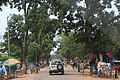
Entrance to the market in Fada N'Gourma | |
 Fada N'gourma Location within Burkina Faso | |
| Coordinates: 12°03′N 0°22′E | |
| Country | |
| Region | Est Region |
| Province | Gourma Province |
| Department | Fada N'Gourma Department |
| Incorporated | 1970 |
| Government | |
| • Mayor | Yendifimba Jean Claude LOUARI[1] |
| Area | |
• Total | 36 km2 (14 sq mi) |
| Elevation | 294 m (965 ft) |
| Population (2019 census)[2] | |
• Total | 73,200 |
| Time zone | UTC+0 (GMT) |
It is primarily known for its blanket and carpet manufacturing as well as honey production.
Etymology
History
The town was founded by Diaba Lompo as Bingo at the beginning of the 13th century.[3] In the 16th and 17th centuries it was the capital of a Gourmantché state that frequently warred with the Songhai Empire.[4] The French arrived at the town in January 1895 and the local Gurma ruler accepted French protection.[3]
Climate
Fada N'gourma has a tropical savanna climate (Köppen climate classification Aw).
| Climate data for Fada N'gourma (1991–2020, extremes 1919–present) | |||||||||||||
|---|---|---|---|---|---|---|---|---|---|---|---|---|---|
| Month | Jan | Feb | Mar | Apr | May | Jun | Jul | Aug | Sep | Oct | Nov | Dec | Year |
| Record high °C (°F) | 41.0 (105.8) |
44.4 (111.9) |
44.1 (111.4) |
45.2 (113.4) |
44.4 (111.9) |
41.4 (106.5) |
39.4 (102.9) |
37.0 (98.6) |
38.8 (101.8) |
41.8 (107.2) |
42.0 (107.6) |
40.4 (104.7) |
45.2 (113.4) |
| Mean daily maximum °C (°F) | 33.8 (92.8) |
36.9 (98.4) |
39.8 (103.6) |
40.1 (104.2) |
37.7 (99.9) |
34.6 (94.3) |
31.9 (89.4) |
30.6 (87.1) |
32.1 (89.8) |
35.4 (95.7) |
36.9 (98.4) |
34.7 (94.5) |
35.4 (95.7) |
| Daily mean °C (°F) | 25.5 (77.9) |
28.6 (83.5) |
32.0 (89.6) |
33.0 (91.4) |
31.5 (88.7) |
29.1 (84.4) |
27.0 (80.6) |
26.1 (79.0) |
26.7 (80.1) |
28.2 (82.8) |
28.0 (82.4) |
26.0 (78.8) |
28.5 (83.3) |
| Mean daily minimum °C (°F) | 18.3 (64.9) |
21.3 (70.3) |
24.9 (76.8) |
27.1 (80.8) |
26.4 (79.5) |
24.5 (76.1) |
23.3 (73.9) |
22.7 (72.9) |
22.8 (73.0) |
23.0 (73.4) |
20.4 (68.7) |
18.5 (65.3) |
22.8 (73.0) |
| Record low °C (°F) | 10.7 (51.3) |
11.4 (52.5) |
15.8 (60.4) |
17.5 (63.5) |
13.5 (56.3) |
15.0 (59.0) |
17.0 (62.6) |
18.5 (65.3) |
18.0 (64.4) |
15.2 (59.4) |
11.8 (53.2) |
8.4 (47.1) |
8.4 (47.1) |
| Average precipitation mm (inches) | 0.0 (0.0) |
2.1 (0.08) |
6.9 (0.27) |
29.0 (1.14) |
81.8 (3.22) |
114.8 (4.52) |
177.5 (6.99) |
249.3 (9.81) |
142.9 (5.63) |
46.3 (1.82) |
0.5 (0.02) |
0.0 (0.0) |
851.1 (33.51) |
| Average precipitation days (≥ 1.0 mm) | 0.0 | 0.1 | 0.8 | 2.7 | 6.7 | 7.9 | 11.2 | 14.1 | 10.0 | 4.5 | 0.1 | 0.0 | 58.1 |
| Average relative humidity (%) | 26 | 25 | 27 | 43 | 58 | 69 | 78 | 84 | 83 | 71 | 46 | 31 | 53 |
| Mean monthly sunshine hours | 268.8 | 245.3 | 249.0 | 238.6 | 254.7 | 238.2 | 217.0 | 192.1 | 214.5 | 260.6 | 271.1 | 274.4 | 2,924.3 |
| Source 1: World Meteorological Organization,[5] Meteo Climat (record highs and lows)[6] | |||||||||||||
| Source 2: Deutscher Wetterdienst (humidity, 1961–1967)[7] | |||||||||||||
Health
The city features both state and private health facilities. The city is the site of a Regional Hospital Center, the reference hospital for the East region.
International relations
Organizations
The following international organizations have offices in Fada N'gourma:
- Action Against Hunger
- Helvetas Swiss Intercooperation
- Initiative: Eau
- Îles de Paix
Sister cities
Fada N'Gourma is twinned with:
 Épernay, France
 Great Barrington, Massachusetts, United States
 Tamale, Ghana
Gallery
 Main street in Fada N'gourma
 Beehives in Fada N'gourma
 Market in Fada N'gourma


