Girgaon Chowpatty
Neighbourhood in Mumbai City, Maharashtra, India
From Wikipedia, the free encyclopedia
Girgaon Chowpatty (IAST: Giragāva Chaupāṭī), is a public beach at the eastern end of the Queen’s Necklace adjoining Malabar Hill in the Girgaon area of Mumbai (Bombay), Maharashtra, India.

Girgaon Chowpatty
Girgaum Chowpatty | |
|---|---|
Neighbourhood | |
 Girgaon Chowpatty during Ganesh Visarjan | |
 Girgaon Chowpatty | |
| Coordinates: 18.951°N 72.811°E | |
| Country | India |
| State | Maharashtra |
| District | Mumbai City |
| City | Mumbai |
| Government | |
| • Type | Municipal Corporation |
| • Body | Brihanmumbai Municipal Corporation (MCGM) |
| Languages | |
| • Official | Marathi |
| Time zone | UTC+5:30 (IST) |
.jpg)
Pollution
The water surrounding the beach is severely polluted and unsafe for swimming. Fecal coliform was recorded in the water in 2013 at levels of 1455 per 100 mL, far above the acceptable standard of 500 per 100 mL. The presence of fecal coliform in the water has been attributed to waste from storm drains, open defecation, and the discharge of raw sewage from sewer pipes not connected to the city mains.[1]
On 30 August 2016, the sand on the beach is said to be turning black due to a possible oil slick in the area. The specific cause of the blackening is unknown.[2]
Images
 Girgaon Chowpatty with Nariman Point skyline in the background
 Girgaon Chowpatty with Malabar Hills in the background
 Corn cob vendors on Girgaon Chowpatty
 Walking
 Walking
 Twilight at Girgaon Chowpatty
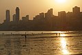 Sunset at Girgaon Chowpatty
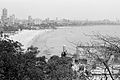 View of Girgaon Chowpatty from Malabar Hill
.jpg)


