Aschau im Chiemgau
Municipality in Bavaria, Germany
From Wikipedia, the free encyclopedia
Aschau im Chiemgau (German pronunciation: [ˈaʃaʊ ʔɪm ˈkiːmɡaʊ] ⓘ, lit. 'Aschau in the Chiemgau') is a municipality and a village in the district of Rosenheim in Bavaria in Germany.

Aschau im Chiemgau | |
|---|---|
Church of Maria Lichtmess in Aschau im Chiemgau | |
 Coat of arms | |
Location of Aschau im Chiemgau
within Rosenheim district 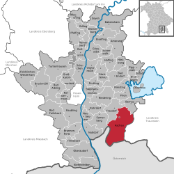 | |
 Location of Aschau im Chiemgau | |
 Aschau im Chiemgau  Aschau im Chiemgau | |
| Coordinates: 47°46′N 12°19′E | |
| Country | Germany |
| State | Bavaria |
| Admin. region | Oberbayern |
| District | Rosenheim |
| Government | |
| • Mayor (2020–26) | Simon Frank[1] |
| Area | |
• Total | 79.59 km2 (30.73 sq mi) |
| Elevation | 615 m (2,018 ft) |
| Population (2024-12-31)[2] | |
• Total | 5,471 |
| • Density | 68.74/km2 (178.0/sq mi) |
| Time zone | UTC+01:00 (CET) |
| • Summer (DST) | UTC+02:00 (CEST) |
| Postal codes | 83229 |
| Dialling codes | 08052, 08057 (Sachrang) |
| Vehicle registration | RO |
| Website | www.aschau.de |
parts
The municipality contains 44 Gemeindeteile:[3]
- Aschach
- Markt Aschau im Chiemgau
- Attich
- Aufham
- Außerkoy
- Außerwald
- Bach
- Berg
- Brückl
- Bucha
- Einfang
- Engerndorf
- Fellerer
- Göttersberg
- Grattenbach
- Grenzhub
- Grünwald
- Hainbach
- Haindorf
- Hammerbach
- Hintergschwendt
- Hohenaschau im Chiemgau
- Höhenberg
- Hub
- Huben
- Innerkoy
- Innerwald
- Kohlstatt
- Mitterleiten
- Pölching
- Reichenau
- Sachrang
- Schlechtenberg
- Schoßrinn
- Schwarzenstein
- Schweibern
- Seehaus
- Spöck
- Staffelstein
- Stein
- Vordergschwendt
- Wald
- Wasserthal
- Weiher
Transport
Aschau im Chiemgau station is part of the Chiemgau Railway.
Personalities
- Hans Clarin (1929-2005), actor and synchronist
- Location of Christian Wolff (born 1938), actor
- Franz Halder, Chief of the General Staff of the German Army High Command, died here in 1972
- Peter Michael Hamel (born 1947), composer, founded the intercultural music institute in Aschau in 1998
- Effective place of Heinz Winkler (chef) (born 1949), cook
- Kurt Zeitzler, chief of the General Army Staff of the Wehrmacht, died here in 1963
Gallery
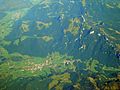 Aschau im Chiemgau Ort
 Sachrang, church Sankt Michael
 Schloss Hohenaschau


Wikimedia Commons has media related to Aschau im Chiemgau.