MRT Line 7 (Metro Manila)
Manila Metro line
From Wikipedia, the free encyclopedia
Metro Rail Transit Line 7 (MRT-7),[4] is an under-construction rapid transit line across Metro Manila in Philippines, with it's phase-1 with 14-stations on 22.8 kilometers (14.2 mi) long route[3] from Bulacan (San Jose del Monte) in a northeast to Quezon City (North Triangle Common Station in North Avenue) in the southwest expected to become partially operational in 2017.
| MRT Line 7 | ||||||||||||||||||||||||||||||||||||||||||||||||||||||||||||||||||||||||||||||||||||||||||||||||||||||||||||||||||||||||||||||||||||||||||||||||||||||||||||||||||||||||||||||||||||||||||||
|---|---|---|---|---|---|---|---|---|---|---|---|---|---|---|---|---|---|---|---|---|---|---|---|---|---|---|---|---|---|---|---|---|---|---|---|---|---|---|---|---|---|---|---|---|---|---|---|---|---|---|---|---|---|---|---|---|---|---|---|---|---|---|---|---|---|---|---|---|---|---|---|---|---|---|---|---|---|---|---|---|---|---|---|---|---|---|---|---|---|---|---|---|---|---|---|---|---|---|---|---|---|---|---|---|---|---|---|---|---|---|---|---|---|---|---|---|---|---|---|---|---|---|---|---|---|---|---|---|---|---|---|---|---|---|---|---|---|---|---|---|---|---|---|---|---|---|---|---|---|---|---|---|---|---|---|---|---|---|---|---|---|---|---|---|---|---|---|---|---|---|---|---|---|---|---|---|---|---|---|---|---|---|---|---|---|---|---|---|
 Hyundai Rotem trains in 2021 | ||||||||||||||||||||||||||||||||||||||||||||||||||||||||||||||||||||||||||||||||||||||||||||||||||||||||||||||||||||||||||||||||||||||||||||||||||||||||||||||||||||||||||||||||||||||||||||
| Overview | ||||||||||||||||||||||||||||||||||||||||||||||||||||||||||||||||||||||||||||||||||||||||||||||||||||||||||||||||||||||||||||||||||||||||||||||||||||||||||||||||||||||||||||||||||||||||||||
| Status | Under construction | |||||||||||||||||||||||||||||||||||||||||||||||||||||||||||||||||||||||||||||||||||||||||||||||||||||||||||||||||||||||||||||||||||||||||||||||||||||||||||||||||||||||||||||||||||||||||||
| Owner | Department of Transportation | |||||||||||||||||||||||||||||||||||||||||||||||||||||||||||||||||||||||||||||||||||||||||||||||||||||||||||||||||||||||||||||||||||||||||||||||||||||||||||||||||||||||||||||||||||||||||||
| Line number | 7 | |||||||||||||||||||||||||||||||||||||||||||||||||||||||||||||||||||||||||||||||||||||||||||||||||||||||||||||||||||||||||||||||||||||||||||||||||||||||||||||||||||||||||||||||||||||||||||
| Locale | Metro Manila and Bulacan, Philippines | |||||||||||||||||||||||||||||||||||||||||||||||||||||||||||||||||||||||||||||||||||||||||||||||||||||||||||||||||||||||||||||||||||||||||||||||||||||||||||||||||||||||||||||||||||||||||||
| Termini | ||||||||||||||||||||||||||||||||||||||||||||||||||||||||||||||||||||||||||||||||||||||||||||||||||||||||||||||||||||||||||||||||||||||||||||||||||||||||||||||||||||||||||||||||||||||||||||
| Stations | 14[1] | |||||||||||||||||||||||||||||||||||||||||||||||||||||||||||||||||||||||||||||||||||||||||||||||||||||||||||||||||||||||||||||||||||||||||||||||||||||||||||||||||||||||||||||||||||||||||||
| Service | ||||||||||||||||||||||||||||||||||||||||||||||||||||||||||||||||||||||||||||||||||||||||||||||||||||||||||||||||||||||||||||||||||||||||||||||||||||||||||||||||||||||||||||||||||||||||||||
| Type | Rapid transit | |||||||||||||||||||||||||||||||||||||||||||||||||||||||||||||||||||||||||||||||||||||||||||||||||||||||||||||||||||||||||||||||||||||||||||||||||||||||||||||||||||||||||||||||||||||||||||
| System | Manila Metro Rail Transit System | |||||||||||||||||||||||||||||||||||||||||||||||||||||||||||||||||||||||||||||||||||||||||||||||||||||||||||||||||||||||||||||||||||||||||||||||||||||||||||||||||||||||||||||||||||||||||||
| Services | 1 | |||||||||||||||||||||||||||||||||||||||||||||||||||||||||||||||||||||||||||||||||||||||||||||||||||||||||||||||||||||||||||||||||||||||||||||||||||||||||||||||||||||||||||||||||||||||||||
| Operator(s) | SMC Mass Rail Transit 7 Incorporated[1] | |||||||||||||||||||||||||||||||||||||||||||||||||||||||||||||||||||||||||||||||||||||||||||||||||||||||||||||||||||||||||||||||||||||||||||||||||||||||||||||||||||||||||||||||||||||||||||
| Rolling stock | Class 000 EMUs | |||||||||||||||||||||||||||||||||||||||||||||||||||||||||||||||||||||||||||||||||||||||||||||||||||||||||||||||||||||||||||||||||||||||||||||||||||||||||||||||||||||||||||||||||||||||||||
| Daily ridership | 300,000 (initial) 850,000 (design capacity) | |||||||||||||||||||||||||||||||||||||||||||||||||||||||||||||||||||||||||||||||||||||||||||||||||||||||||||||||||||||||||||||||||||||||||||||||||||||||||||||||||||||||||||||||||||||||||||
| History | ||||||||||||||||||||||||||||||||||||||||||||||||||||||||||||||||||||||||||||||||||||||||||||||||||||||||||||||||||||||||||||||||||||||||||||||||||||||||||||||||||||||||||||||||||||||||||||
| Commenced | August 15, 2017 | |||||||||||||||||||||||||||||||||||||||||||||||||||||||||||||||||||||||||||||||||||||||||||||||||||||||||||||||||||||||||||||||||||||||||||||||||||||||||||||||||||||||||||||||||||||||||||
| Planned opening | Q2 2027 (Full)[2] | |||||||||||||||||||||||||||||||||||||||||||||||||||||||||||||||||||||||||||||||||||||||||||||||||||||||||||||||||||||||||||||||||||||||||||||||||||||||||||||||||||||||||||||||||||||||||||
| Technical | ||||||||||||||||||||||||||||||||||||||||||||||||||||||||||||||||||||||||||||||||||||||||||||||||||||||||||||||||||||||||||||||||||||||||||||||||||||||||||||||||||||||||||||||||||||||||||||
| Line length | 24.069 km (14.956 mi) | |||||||||||||||||||||||||||||||||||||||||||||||||||||||||||||||||||||||||||||||||||||||||||||||||||||||||||||||||||||||||||||||||||||||||||||||||||||||||||||||||||||||||||||||||||||||||||
| Number of tracks | Double-track | |||||||||||||||||||||||||||||||||||||||||||||||||||||||||||||||||||||||||||||||||||||||||||||||||||||||||||||||||||||||||||||||||||||||||||||||||||||||||||||||||||||||||||||||||||||||||||
| Character | Grade separated | |||||||||||||||||||||||||||||||||||||||||||||||||||||||||||||||||||||||||||||||||||||||||||||||||||||||||||||||||||||||||||||||||||||||||||||||||||||||||||||||||||||||||||||||||||||||||||
| Track gauge | 1,435 mm (4 ft 8+1⁄2 in) standard gauge | |||||||||||||||||||||||||||||||||||||||||||||||||||||||||||||||||||||||||||||||||||||||||||||||||||||||||||||||||||||||||||||||||||||||||||||||||||||||||||||||||||||||||||||||||||||||||||
| Electrification | 750 V DC third rail[3] | |||||||||||||||||||||||||||||||||||||||||||||||||||||||||||||||||||||||||||||||||||||||||||||||||||||||||||||||||||||||||||||||||||||||||||||||||||||||||||||||||||||||||||||||||||||||||||
| Average inter-station distance | 1.85 km (1.15 mi) | |||||||||||||||||||||||||||||||||||||||||||||||||||||||||||||||||||||||||||||||||||||||||||||||||||||||||||||||||||||||||||||||||||||||||||||||||||||||||||||||||||||||||||||||||||||||||||
| ||||||||||||||||||||||||||||||||||||||||||||||||||||||||||||||||||||||||||||||||||||||||||||||||||||||||||||||||||||||||||||||||||||||||||||||||||||||||||||||||||||||||||||||||||||||||||||
MRT-7 will be expanded to a 200-kilometer (120 mi) network in phases, including a main loop-line as an extension of the present line, as well as several other phased extensions such as the New Manila International Airport Link, the West Rail Link, Manila North Harbor-North Avenue Common Station Link, etc.
History
1993-2015: early planning and delays
A route envisaged under the 1993 Traffic and Transport Management Plan, named Metro Manila LRT Line-4,[5][6] with various alignment suggestions.[7][8][9] on the suggestions of Japan International Cooperation Agency was later split into MRT-7 and the MRT Line 8 in 1999.[10] On August 27, 2001, an early proposal of the MRT-7 project was submitted to the government,[11][12][13] and in 2008 a subsidiary of San Miguel Corporation (SMC) was contracted to build the line.[14][15]
In May 2012, SMC awarded the construction contract to the joint venture of Marubeni Corporation and DMCI,[16][17] which was approved by the government of President Benigno Aquino III on 21 November 2013 on a public-private partnership (PPP) model.[18][19]
2016-28: Phase-1 construction

On 20 April 2016, 15 years after initial development began the President Benigno Aquino III held the ground breaking ceremoney,[20] but the actual construction on the phase-1 22.8-kilometer (14.2 mi) line officially started on 15 August 2017.[21][22][23] The project also includes construction of a 22-kilometer (14 mi) highway from the NLEX Bocaue Interchange, up to the proposed intermodal transport terminal (ITT) located near San Jose del Monte station.[1]
Overview
Rolling stock & depot
There are 36 Hyundai Rotem trainsets or 108 train cars costing $440.2 million, configured into 3 cars per train set expandable up to 6 cars per train set, have been acquired.[24][25][26][27] The trains will maintain an at-grade 20 hectares (49 acres) depot in Quezon City,[28][29] capable of handling 150 trains sets.[30]
Route
The route has 14 stations with North EDSA as an interchange with the other metro lines such as the Line 1 and Line 3.
| No.[31] | Station | Distance (km)[32] | Structure type | Connections | Location | |
|---|---|---|---|---|---|---|
| Between stations |
Total | |||||
| S01 | North EDSA[31] | — | 0.000 | Elevated | Interchange with Interchange with
|
Quezon City |
| S02 | Quezon Memorial Circle[31] | 1.665 | 1.665 | Depressed | Proposed interchange with
| |
| S03 | University Avenue | 0.837 | 2.502 | Depressed | Proposed interchange with
| |
| S04 | Tandang Sora | 1.664 | 4.166 | Elevated |
| |
| S05 | Don Antonio | 2.254 | 6.420 | Elevated |
| |
| S06 | Batasan | 0.976 | 7.396 | Elevated |
| |
| S07 | Manggahan | 1.390 | 8.786 | At-grade |
| |
| S08 | Doña Carmen | 1.472 | 10.258 | Elevated |
| |
| S09 | Regalado Avenue[31] | 1.145 | 11.403 | Elevated |
| |
| S10 | Mindanao Avenue | 3.416 | 14.819 | Elevated |
| |
| S11 | Quirino[31] | 0.800 | 15.619 | Elevated |
| |
| S12 | Sacred Heart | 2.642 | 18.621 | Elevated |
|
Caloocan |
| S13 | Tala | 2.625 | 20.886 | Elevated |
| |
| S14 | San Jose Del Monte | TBA | TBA | Elevated |
|
San Jose del Monte, Bulacan |
| Stations, lines, and/or other transport connections in italics are either under construction, proposed, unopened, or have been closed. | ||||||
Future phases
Phase 2A (Tutuban Link)
Phase 2A, entails extension of the phase-1 route to Tutuban station.[34]
| Name | Line transfers | Barangay | City/Municipality | Nearest Landmarks |
|---|---|---|---|---|
| West Avenue | none | Phil-Am | Quezon City | None |
| Delta | West Triangle | Capitol Medical Center, St. Mary's College | ||
| A. Roces | Paligsahan | Fisher Mall, Amoranto Sports Complex | ||
| Santo Domingo | Santo Domingo | Santo Domingo Church, UST Angelicum College | ||
| D. Tuazon | Santa Mesa Heights | Welcome Rotonda, National Labor Relations Commission | ||
| España Boulevard | Sampaloc | Manila | Trabajo Market | |
| Lacson | none | University of Santo Tomas | ||
| Legarda | San Sebastian Church, University Belt (Mendiola Street section) | |||
| Recto | Santa Cruz | Isetann Recto, Manila City Jail | ||
| Tutuban | Tondo | Tutuban Center (Old Tutuban Station), Divisoria | ||
| North Port | Port of Manila |
Phase 2B (West Rail Link)
Phase 2B, the West Rail Link, will be an airport rail link to New Manila International Airport.[35]
| Name | Line transfers | Barangay | City/Municipality | Nearest Landmarks |
|---|---|---|---|---|
| North Port | none | 221 | Manila | North Port Passenger Terminal |
| Don Bosco | 107 | Manila North Harbour | ||
| Navotas | North Bay Blvd., South | Navotas | Navotas Fisheries Port Complex | |
| Bulakan Airport | Taliptip and Bambang | Bulakan, Bulacan | New Manila International Airport |
Phase 3 (Bulacan Airport Access)
Line will be extended to Bocaue, Bulacan along the planned six-lane highway connecting to the North Luzon Expressway,[36] Ciudad de Victoria, Philippine Arena,[37] thus connecting the Metro Manila with New Manila International Airport by adding 30.3 kilometers (18.8 mi) to the present line to 53.1 kilometers (33.0 mi).[38][39]
| Name | Line transfers | Barangay | City/Municipality | Nearest Landmarks |
|---|---|---|---|---|
| Tungkong Mangga | Tungkong Mangga | San Jose del Monte | Savano Park, SM San Jose Del Monte | |
| Palmera | none | Kaypian, Santo Cristo | Starmall San Jose Del Monte | |
| Sapang Palay | Sapang Palay Proper | Motorpool, Sports Complex | ||
| San Vicente | San Vicente | Santa Maria | Bella Vista | |
| Philippine Arena | Tabing Bakod | Philippine Arena, Philippine Sports Stadium | ||
| NSCR Marilao | Ibayo | Marilao | SM City Marilao | |
| Bulakan Airport | Taliptip | Bulakan | New Manila International Airport |
Phase 4A (Southeast Link)
Phase 4A involves the construction of an extension from the "D. Tuazon Station" of Phase 2A to Taytay, Rizal with 10 new stations running on a northwest–southeast alignment.[34]
| Name | Line transfers | Barangay | City/Municipality | Nearest Landmarks |
|---|---|---|---|---|
| Araneta Avenue | none | Tatalon | Quezon City | De Los Santos Medical Center, St. Luke's Medical Center – Quezon City, Trinity University of Asia |
| E. Rodriguez | Kristong Hari | Christ the King Seminary, Barangay Mariana Park, Quezon City Sports Club | ||
| Gilmore | Mariana | Gilmore Commercial Plaza, St. Paul University Quezon City | ||
| Greenhills | none | Greenhills | San Juan | Cardinal Santos Medical Center, Greenhills Shopping Center |
| POEA–Ortigas | Wack Wack–Greenhills | Mandaluyong | EDSA Shrine, La Salle Green Hills, Philippine Overseas Employment Administration, Robinsons Galleria, Wack Wack Golf and Country Club | |
| Meralco Avenue | Ugong | Pasig | Meralco Main Office, The Medical City | |
| Pasig | None | Rosario | Sto. Rosario de Pasig Church | |
| Bonifacio Avenue | Santo Domingo | Cainta, Rizal | Robinsons Cainta | |
| L. Wood | None | San Isidro | Taytay, Rizal | Taytay Rotonda Monument |
| Taytay | Dolores | Taytay Public Market, Taytay Municipal Hall | ||
Phase 4B (U-Link)
Phase 4B spur from Ortigas Center to V. Mapa station of LRT Line-2 with 6 new stations on a U-shaped route.[34]
Phase 5 (Katipunan Link)
13.9 kilometers (8.6 mi) MRT-7 Katipunan Spur Line, with 8 new stations will connect Tandang Sora station to the LRT Line 2 (at Katipunan and Marikina stations) and MRT 4 Cainta Station (U.P. Town Center, Ateneo de Manila University, the Riverbanks Center).[40][41]
| Name | Line transfers | Location | Nearest landmarks |
|---|---|---|---|
| Tandang Sora | Matandang Balara, Quezon City | New Era University, Commonwealth Avenue | |
| Balara | none | University of the Philippines Diliman, MWSS, Balara Filters Park | |
| U.P. Town Center | Diliman, Quezon City | U.P. Town Center, C.P. Garcia Avenue (UP), Brgy. Pansol | |
| Ateneo | Loyola Heights, Quezon City | Miriam College, Ateneo de Manila University | |
| Katipunan | Xavierville Avenue, Aurora Boulevard, Project 2 & 3 | ||
| Riverbanks | none | Marikina | Riverbanks Center, Barangka, Provident Village |
| Sumulong | Marikina City Hall, Amang Rodriguez Memorial Medical Center, Sumulong Highway | ||
| Emerald-Marikina | Marikina–Infanta Highway, Sta. Lucia East, Robinsons Metro East | ||
| Bonifacio Avenue | 4 Cainta | Cainta, Rizal | Ortigas Avenue Extension, Cainta Public Market, Robinsons Cainta |
Gallery
- MRT-7 groundbreaking by then President Benigno Aquino III, c. April 2016.
 Under-construction MRT-7 Quezon City depot.
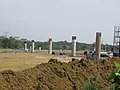
 Batasan Station under construction in Quezon City, c. August 2018.
 Phase-1 track construction along Commonwealth Avenue, c. March 2021.
 President Rodrigo Duterte unveiling the Hyundai Rotem EMU train sets for MRT-7, c. December 2021.
- Trainset test run at Batasan station, c June 2025.


.jpg)
_along_Commonwealth_Avenue_in_Diliman,_Quezon_City_on_December_16,_2021.jpg)
Present status
- Phase-1 Targets
- Late 2027: Phase-1 partial completion (from Sacred Heart (North EDSA) to Tala)
- Late 2028: Phase-1 100% completion (extend from Tala to San Jose del Monte)
- 2025 Jun: MRT‑7 Phase-1 is 83% complete, progress on target for partial operations in early 2027.[42]