Alif Alif Atoll
Atoll in Maldives
From Wikipedia, the free encyclopedia
Alif Alif Atoll (also known as Northern Ari Atoll or Ari Atholhu Uthuruburi) is an administrative division of the Maldives. It was created on March 1, 1984, combining northern section of Ari Atoll, the small Rasdhukuramathi Atoll, and the isolated island of Thoddoo. Many of the islands in this atoll have been inhabited since ancient times and have archaeological remains from the Maldivian Buddhist period.

Alifu Alifu Atoll | |
|---|---|
| |
 Location in Maldives | |
| Country | Maldives |
| Corresponding geographic atoll(s) | Ari Atoll Uthuruburi |
| Location | 4° N and 72.8° E |
| Capital | Rasdhoo |
| Government | |
| • Atoll Chief | |
| Population | |
• Total | 5,905 |
| Letter code | U |
| Dhivehi letter code | AA (އއ) |
| • Number of islands | 33 |
| • Inhabited islands | Bodufolhudhoo Feridhoo Himandhoo Maalhos Mathiveri Rasdhoo Thoddoo Ukulhas |
| • Uninhabited islands | Alikoirah, Bathalaa*, Beyrumadivaru, Dhin-nolhufinolhu, Ellaidhoo*, Etheramadivaru, Fesdhoo*, Fusfinolhu, Fushi, Gaagandu, Gaathufushi*, Gangehi*, Halaveli*, Kandholhudhoo*, Kudafolhudhoo*, Kuramathi*, Maagaa, Maayyafushi*, Madivarufinolhu, Madoogali, Mathivereefinolhu, Meerufenfushi, Mushimasgali, Rasdhoo madivaru, Velidhoo*, Veligandu*, Vihamaafaru |
| Resort islands(*), airports(¤) and industrial islands are also considered uninhabited. | |
The separation of Ari Atoll (formerly Alifu Atoll) into a Northern and a Southern section has formed the two most recent administrative divisions of the Maldives, namely Alifu Alifu Atoll and Alifu Dhaalu Atoll.
Geography
The North Ari Atoll administrative division consists of the northern part of the geographic or natural atoll Ari Atoll (described as Northern Ari Atoll in this context to differentiate from the official name of the administrative division), Rasdhukuramathi Atoll and Thoddoo Island. The atolls consist of Inhabited Islands and Uninhabited Island, a definition which includes resort islands, airport islands and industrial islands.
Inhabited islands
| Name | Population[1] | Coordinates[2] | Geographic Atoll/Island | Remarks |
|---|---|---|---|---|
| Bodufolhudhoo | 586 | 4°11′7″N 72°46′23″E | Northern Ari Atoll | |
| Feridhoo | 413 | 4°3′3″N 72°43′31″E | Northern Ari Atoll | |
| Himandhoo | 667 | 3°55′15″N 72°44′38″E | Northern Ari Atoll | |
| Maalhos | 408 | 3°59′13″N 72°43′11″E | Northern Ari Atoll | |
| Mathiveri | 623 | 4°11′30″N 72°44′46″E | Northern Ari Atoll | |
| Rasdhoo | 949 | 4°15′46″N 72°59′31″E | Rasdhukuramathi Atoll | Capital of North Ari Atoll administrative division, known as Ross Atoll in the Admiralty Charts |
| Thoddoo | 2,023 | 4°26′20″N 72°57′31″E | Thoddoo Island | |
| Ukulhas | 921 | 4°12′53″N 72°51′50″E | Northern Ari Atoll |
Maalhos: Maalhos is geographically the westernmost island of the atoll and the second-most westerly inhabited island of the Maldives after Maamakunudhoo. Vajrayana Buddhist remains have been found on this island.
Rasdhoo: Rasdhoo is the capital island of the North Ari Atoll administrative division. It has ferry connections with Malé as well as the other inhabited islands of the atoll. The island has several guesthouses catering to tourists visiting inhabited islands rather than resort islands.
Resort islands
Resort islands are classified as Uninhabited Islands which have been converted to become resorts. The following are the resort islands, with the official name of the resort.
| Name | Resort Name | Coordinates[3] | Geographic Atoll | Remarks |
|---|---|---|---|---|
| Bathalaa | Bathala Island Resort[4] | 4°4′13″N 72°56′43″E | Northern Ari Atoll | |
| Ellaidhoo | Ellaidhoo Maldives[5] | 4°0′22″N 72°56′56″E | Northern Ari Atoll | |
| Fesdhoo | W Maldives[6] | 4°0′24″N 72°48′39″E | Northern Ari Atoll | |
| Gaathafushi | Gaathufushi Private Island [7] | 4°1′24″N 72°48′38″E | Northern Ari Atoll | Owned by W Maldives |
| Gangehi | Gangehi Island Resort[8] | 4°13′12″N 72°45′18″E | Northern Ari Atoll | Owned by UHC Resorts |
| Halaveli | Constance Halaveli[9] | 4°2′17″N 72°55′9″E | Northern Ari Atoll | |
| Kan'dholhudhoo | Kandolhu Maldives[10] | 4°0′9″N 72°52′53″E | Northern Ari Atoll | |
| Kudafolhudhoo | Nika Island Resort[11] | 4°10′52″N 72°46′1″E | Northern Ari Atoll | |
| Kuramathi | Kuramathi Maldives[12] | 4°15′33″N 72°58′45″E | Rasdhukuramathi Atoll | |
| Maayafushi | Voi Maayafushi Resort | 4°4′25″N 72°53′15″E | Northern Ari Atoll | |
| Velidhoo | Velidhoo Island Resort | 4°11′41″N 72°49′6″E | Northern Ari Atoll | |
| Veligandu | Veligandu Island Resort[13] | 4°17′56″N 73°0′41″E | Northern Ari Atoll |
Veligandu: Veligandu covers 22 acres (8.9 ha) and is 600 metres long. It is a holiday resort with 91 rooms and a snorkelling reef. A large number of workers at the resort come from Sri Lanka and India. The island is linked to Male by seaplane services.
Other uninhabited islands
| Name | Current usage | Coordinates | Geographic Atoll/Island | Remarks |
|---|---|---|---|---|
| Alikoirah | 3°56′36″N 72°52′49″E | Northern Ari Atoll | ||
| Etheremadivaru | 4°7′7″N 72°56′16″E | Northern Ari Atoll | Earmarked for resort development by Emaar Group as Address Madivaru, scheduled for opening in 2020.[14] | |
| Fusfinolhu | 4°1′6″N 72°57′30″E | Northern Ari Atoll | ||
| Fushi | 4°12′56″N 72°53′1″E | Northern Ari Atoll | ||
| Gaagandu | 4°13′58″N 72°51′54″E | Northern Ari Atoll | ||
| Maagau | 3°59′20″N 72°57′25″E | Northern Ari Atoll | ||
| Madivaru | 4°15′55″N 72°0′0″E | Northern Ari Atoll | Formerly Banyan Tree Madivaru, now closed | |
| Madivarufinolhu | 4°16′7″N 73°0′0″E | Rasdhukuramathi Atoll | ||
| Madoogali | 4°5′45″N 72°45′10″E | Northern Ari Atoll | ||
| Mathivereefinolhu | 4°11′6″N 72°45′2″E | Northern Ari Atoll | ||
| Mushimasmigili | 3°57′32″N 72°54′47″E | Northern Ari Atoll | ||
| Vihamaafaru | 4°7′19″N 72°44′47″E | Northern Ari Atoll |
Gallery
 An isolated spit in the middle of the Rasdhukuramathi Atoll
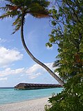 Veligandu Island resort

