Wensu County
County in Xinjiang, China
From Wikipedia, the free encyclopedia
Wensu County (Chinese: 温宿县), also known as Onsu County[2][3][4][5][6] (Uyghur: ئونسۇ ناھىيىسى, romanized: Onsu Nahiyisi[7]), is a county in the Xinjiang Uygur Autonomous Region of China, under the administration of Aksu Prefecture, bordering Kyrgyzstan's Issyk-Kul Region to the northwest. It has an area of 14,309 km2 (5,525 sq mi).

Wensu County
Onsu, Kona Shahr, Wensuh | |
|---|---|
Aerial view of Wensu County in 2024 | |
.png) Location of Wensu County (red) within Aksu Prefecture (yellow) and Xinjiang | |
 Wensu County Location of the seat  Wensu County Wensu County (China) | |
| Coordinates: 41°15′N 80°14′E | |
| Country | China |
| Autonomous region | Xinjiang |
| Prefecture | Aksu |
| County seat | Wensu Town |
| Area | |
• Total | 14,335.16 km2 (5,534.84 sq mi) |
| Population (2020)[1] | |
• Total | 266,002 |
| • Density | 18.5559/km2 (48.0596/sq mi) |
| Ethnic groups | |
| • Major ethnic groups | Uyghur[2] |
| Time zone | UTC+8 (China Standard[a]) |
| Postal code | 843100 |
| Website | www |
| Wensu County | |||||||||||
|---|---|---|---|---|---|---|---|---|---|---|---|
| Chinese name | |||||||||||
| Simplified Chinese | 温宿县 | ||||||||||
| Traditional Chinese | 溫宿縣 | ||||||||||
| |||||||||||
| Uyghur name | |||||||||||
| Uyghur | ئونسۇ ناھىيىسى | ||||||||||
| |||||||||||
Etymology
The toponym Wensu (温宿) had appeared in historical records of the Western Han Dynasty as one of the 36 states in the Western Regions.[8][9] The name 'Onsu' means "ten rivers" in Uyghur and other Turkic languages.[10] The name is similar to that of the nearby Zhetysu region which means "seven rivers"- both names consist of a number followed by 'su' (river; water).[11] The name Aksu is Turkic for 'white water'.[12]
In Uyghur, the county is called Aksu Konaxahar (阿克苏阔纳协海尔) meaning 'the old city of Aksu'.[13]
History
Wensu County was established in 1902.[14]
On May 29, 1958, Wensu County was eliminated and its territory made part of Aksu County. In 1962, Wensu County was restored.[15]
In a Radio Free Asia interview, a Han Chinese staffer in the Wensu County local government said that in July 2017, a policy to affix QR codes to all knives belonging to Uyghurs was being carried out.[16]
As of March 2018, every cadre in the county was required to spend eight days a month at the home of villagers.[17]
In the late 2010s, Wensu County was the site of vocational education and training centers (also understood as deradicalization centers, re-education camps or concentration camps).[18][19] According to a Radio Free Asia interview with an officer at the Wensu county police station, as of August 2018, 30,000 persons, or about one in six Uyghurs in the county (approximately 16% of the overall population of the county), were detained in re-education camps.[2]
Administrative divisions
Wensu County administered 8 towns, 4 townships, and 1 ethnic township.[20][21]
| Name | Simplified Chinese | Hanyu Pinyin | Uyghur (UEY) | Uyghur Latin (ULY) | Administrative division code | Notes | |
|---|---|---|---|---|---|---|---|
| Towns | |||||||
| Onsu Town (Wensu Town) |
温宿镇 | Wēnsù Zhèn | ئونسۇ بازىرى | Onsu baziri | 652922100 | ||
| Tumxuk Town[22] | 吐木秀克镇 | Tǔmùxiùkè Zhèn | تۇمشۇق بازىرى | tumshuq baziri | 652922101 | formerly Tumxuk Township (吐木秀克乡) | |
| Qizil Town | 克孜勒镇 | Tǔmùxiùkè Zhèn | قىزىل بازىرى[23] | qizil baziri | 652922102 | formerly Qizil Township (克孜勒乡) | |
| Aral Town[24] | 阿热勒镇 | Ārèlè Zhèn | ئارال بازىرى | Aral baziri | 652922103 | formerly Aral Township (阿热勒乡) | |
| Jam Town | 佳木镇 | Jiāmù Zhèn | جام بازىرى[25] | jam baziri | 652922104 | formerly Jam Township (佳木乡) | |
| Topkhan Town | 托甫汗镇 | Tuōfǔhàn Zhèn | توپقان بازىرى | topqan baziri | 652922105 | ||
| Komsumul Town | 共青团镇 | Gòngqīngtuán Zhèn | كومسۇمۇل بازىرى | komsumul baziri | 652922106 | ||
| Kökyar Town | 柯柯牙镇 | Kēkēyá Zhèn | كۆكيار بازىرى | kökyar baziri | 652922107 | ||
| Townships | |||||||
| Toxula Township | 托乎拉乡 | Tuōhūlā Xiāng | توخۇلا يېزىسى[26] | toxula yëzisi | 652922200 | ||
| Chaghraq Township | 恰格拉克乡 | Qiàgélākè Xiāng | چاغراق يېزىسى | chaghraq yëzisi | 652922202 | ||
| Ishlemchi Township | 依希来木其乡 | Yīxīláimùqí Xiāng | ئىشلەمچى يېزىسى | Ishlemchi yëzisi | 652922204 | ||
| Gulawat Township (Gule Awati[27]) |
古勒阿瓦提乡 | Gǔlè'āwǎtí Xiāng | گۈلئاۋات يېزىسى | gül'awat yëzisi | 652922206 | ||
| Ethnic township | |||||||
| Bozdong Kyrgyz Ethnic Township | 博孜墩柯尔克孜族乡 | Bózīdūn Kē'ěrkèzīzú Xiāng | بوزدۆڭ قىرغىز يېزىسى | bozdöng qirghiz yëzisi | 652922207 | (Kyrgyz) بوزدۅڭ قىرعىز ايىلى Боздөң Кыргыз айылы | |
Climate
| Climate data for Onsu, elevation 1,133 m (3,717 ft), (1991–2020 normals, extremes 1991–present) | |||||||||||||
|---|---|---|---|---|---|---|---|---|---|---|---|---|---|
| Month | Jan | Feb | Mar | Apr | May | Jun | Jul | Aug | Sep | Oct | Nov | Dec | Year |
| Record high °C (°F) | 8.1 (46.6) |
17.1 (62.8) |
26.8 (80.2) |
34.6 (94.3) |
34.7 (94.5) |
37.0 (98.6) |
39.6 (103.3) |
38.2 (100.8) |
33.9 (93.0) |
28.9 (84.0) |
23.0 (73.4) |
9.8 (49.6) |
39.6 (103.3) |
| Mean daily maximum °C (°F) | −1.0 (30.2) |
5.3 (41.5) |
14.2 (57.6) |
22.4 (72.3) |
26.8 (80.2) |
29.9 (85.8) |
31.3 (88.3) |
30.2 (86.4) |
26.2 (79.2) |
19.4 (66.9) |
9.8 (49.6) |
0.8 (33.4) |
17.9 (64.3) |
| Daily mean °C (°F) | −7.3 (18.9) |
−1.1 (30.0) |
8.0 (46.4) |
15.8 (60.4) |
20.2 (68.4) |
23.1 (73.6) |
24.4 (75.9) |
23.2 (73.8) |
18.9 (66.0) |
11.7 (53.1) |
2.9 (37.2) |
−4.9 (23.2) |
11.2 (52.2) |
| Mean daily minimum °C (°F) | −12.5 (9.5) |
−6.8 (19.8) |
1.7 (35.1) |
9.2 (48.6) |
13.9 (57.0) |
16.7 (62.1) |
18.0 (64.4) |
16.8 (62.2) |
12.3 (54.1) |
4.9 (40.8) |
−2.3 (27.9) |
−9.1 (15.6) |
5.2 (41.4) |
| Record low °C (°F) | −24.5 (−12.1) |
−24.7 (−12.5) |
−9.5 (14.9) |
−1.0 (30.2) |
4.8 (40.6) |
10.3 (50.5) |
11.5 (52.7) |
9.6 (49.3) |
3.9 (39.0) |
−3.4 (25.9) |
−10.1 (13.8) |
−22.5 (−8.5) |
−24.7 (−12.5) |
| Average precipitation mm (inches) | 1.8 (0.07) |
3.2 (0.13) |
4.0 (0.16) |
5.4 (0.21) |
9.6 (0.38) |
19.6 (0.77) |
15.7 (0.62) |
15.9 (0.63) |
12.6 (0.50) |
4.4 (0.17) |
2.5 (0.10) |
3.4 (0.13) |
98.1 (3.87) |
| Average precipitation days (≥ 0.1 mm) | 2.9 | 2.4 | 1.4 | 1.9 | 3.8 | 6.6 | 6.3 | 7.0 | 4.2 | 1.4 | 1.2 | 2.9 | 42 |
| Average snowy days | 5.7 | 3.6 | 0.8 | 0.1 | 0 | 0 | 0 | 0 | 0 | 0 | 1.4 | 5.8 | 17.4 |
| Average relative humidity (%) | 68 | 59 | 44 | 37 | 41 | 48 | 52 | 56 | 57 | 57 | 64 | 72 | 55 |
| Mean monthly sunshine hours | 177.1 | 182.3 | 199.7 | 224.8 | 264.7 | 281.5 | 300.5 | 278.1 | 250.0 | 246.4 | 192.4 | 158.1 | 2,755.6 |
| Percentage possible sunshine | 59 | 60 | 53 | 56 | 59 | 62 | 66 | 66 | 68 | 73 | 66 | 56 | 62 |
| Source: China Meteorological Administration[28][29] | |||||||||||||
Economy
Demographics
| Year | Pop. | ±% p.a. |
|---|---|---|
| 2000 | 219,219 | — |
| 2010 | 233,933 | +0.65% |
| [20] | ||
As of 2015, 197,360 of the 259,305 residents of the county were Uyghur, 55,335 were Han Chinese and 6,610 were from other ethnic groups.[31]
According to the 2002 census, it has a population of 210,000.[citation needed]
As of 1999, 76.17% of the population of Wensu County was Uyghur and 21.43% of the population was Han Chinese.[32]
Transportation
Historical maps
Historical English-language maps including Onsu:
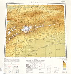 Map including Uqturpan (labeled as WEN-SU (AKSU-KONE SHAHR)) and surrounding region from the International Map of the World (AMS, 1950)[b]
 Map including Onsu (labeled as WENSU) (DMA, 1981)
_-_panoramio.jpg)


Notes
- Locals in Xinjiang frequently observe UTC+6 (Xinjiang Time), 2 hours behind Beijing.
- From map: "THE DELINEATION OF INTERNATIONAL BOUNDARIES ON THIS MAP MUST NOT BE CONSIDERED AUTHORITATIVE"
- From map: "The representation of international boundaries is not necessarily authoritative."