Rônai
Commune in Normandy, France
From Wikipedia, the free encyclopedia
Rônai (French pronunciation: [ʁonɛ] ⓘ) is a commune in the Orne department in north-western France.

Rônai | |
|---|---|
The town hall in Rônai | |
 Location of Rônai | |
  Rônai  Rônai | |
| Coordinates: 48°48′51″N 0°08′06″W | |
| Country | France |
| Region | Normandy |
| Department | Orne |
| Arrondissement | Argentan |
| Canton | Argentan-1 |
| Intercommunality | Terres d'Argentan Interco |
| Government | |
| • Mayor (2020–2026) | Hubert Séjourné[1] |
Area 1 | 5.40 km2 (2.08 sq mi) |
| Population (2023)[2] | 182 |
| • Density | 33.7/km2 (87.3/sq mi) |
| Time zone | UTC+01:00 (CET) |
| • Summer (DST) | UTC+02:00 (CEST) |
| INSEE/Postal code | 61352 /61160 |
| Elevation | 194–260 m (636–853 ft) (avg. 218 m or 715 ft) |
| 1 French Land Register data, which excludes lakes, ponds, glaciers > 1 km2 (0.386 sq mi or 247 acres) and river estuaries. | |
Geography
The commune of Rônai borders Suisse Normande to the west of its borders.[3][4] The commune is spread over an area of 5.4 square kilometres (1,300 acres) with a maximum altitude of 260 metres (853 ft 0 in) and minimum of 194 metres (636 ft 6 in)[5]
Parts of the commune make up the area, the Plaine d'Argentan, which is known for its cereal growing fileds and horse stud farms.[6]
The commune is made up of the following collection of villages and hamlets, Rônai and Pierrefitte
Land distribution
The 2018 CORINE Land Cover assessment shows the vast majority of the land in the commune, 63% (342 hectares (850 acres)) is Arable land.[5] The rest of the land is Meadows at 15%, and 110 hectares (270 acres) or 20% is classed as Heterogeneous agricultural land.[5]
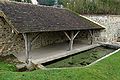 lavoir at Rônai
 St-Martin fountain at Rônai
 Rônai church


