Shinhidaka, Hokkaido
Town in Hokkaido, Japan
From Wikipedia, the free encyclopedia
Shinhidaka (新ひだか町, Shinhidaka-chō) is a town located in Hidaka Subprefecture, Hokkaidō, Japan. As of 31 December 2025[update], the town had an estimated population of 19,785 in 1120 households, and a population density of 17 people per km2.[1] The total area of the town is 1,147.55 km2 (443.07 sq mi). Although Urakawa is the capital of Hidaka Subprefectre, Shinhidaka is the most populous town, and the economic center of the subprefecture.

Shinhidaka
新ひだか町 | |
|---|---|
Shinhidaka Town Hall | |
 Flag  Seal | |
 Location of Shinhidaka in Hokkaido (Hidaka Subprefecture) | |
 Interactive map of Shinhidaka | |
 Shinhidaka | |
| Coordinates: 42°20′29″N 142°22′07″E | |
| Country | Japan |
| Region | Hokkaido |
| Prefecture | Hokkaido (Hidaka Subprefecture) |
| District | Hidaka |
| Government | |
| • Mayor | Yoshihide Sakai |
| Area | |
• Total | 1,147.55 km2 (443.07 sq mi) |
| Population (December 31, 2025) | |
• Total | 19,785 |
| • Density | 17.241/km2 (44.654/sq mi) |
| Time zone | UTC+09:00 (JST) |
| City hall address | 3-2-50, Shizunai Miyukichō, Shinhidaka-chō, Hidaka-gun, Hokkaidō 056-8650 |
| Climate | Dfb |
| Website | www |
| Symbols | |
| Flower | Ezoyamatsutsuji (Rhododendron kaempferi) and beach rose (Rosa rugosa) |
| Mascot | Konbuman (こんぶマン) and Kobune-chan (こぶねちゃん) |
| Tree | Ezoyamazakura and Japanese ash |

Geography
Shinhidaka is located in southern Hokkaido, in the central coastal area of the Hidaka Subprefecture. The southwestern part faces the Pacific Ocean, and the mountainous area originating from the Hidaka Mountains in the northeastern part is designated as the Hidakasanmyaku-Erimo-Tokachi National Park. The southern part faces the Pacific Ocean. The urban area spreads out at the mouth of the Shizunai River.[2] Its highest location is Mount Kamuiekuuchikaushi (42°37′30″N 142°45′58″E) at 1,979.4 m (6,494 ft). Takami Dam, Hokkaido's largest dam, is located in Shinhidaka.
Neighboring municipalities
Climate
Shinhidaka has a humid continental climate (Köppen Dfb) with warm summers and cold winters. With an alternate definition, using the −3 °C (27 °F) isotherm, Shinhidaka falls in the rare oceanic climate (Cfb) of the east coast of the continents due to the warm current of Tsushima. Owing to its slightly more southerly latitude, easterly aspect and location on the sea, snowfall is much lighter than in the major cities of western Hokkaido like Sapporo, Hakodate, Asahikawa and Wakkanai.[3] Precipitation in heaviest in the summer months when remnant typhoons may approach. Year-round sunshine, although less than in the Tokachi Plain, is also higher than western Hokkaido
| Climate data for Mitsuishi, Shinhidaka (1991−2020 normals, extremes 1977−present) | |||||||||||||
|---|---|---|---|---|---|---|---|---|---|---|---|---|---|
| Month | Jan | Feb | Mar | Apr | May | Jun | Jul | Aug | Sep | Oct | Nov | Dec | Year |
| Record high °C (°F) | 10.7 (51.3) |
10.5 (50.9) |
17.3 (63.1) |
22.6 (72.7) |
25.8 (78.4) |
28.4 (83.1) |
32.1 (89.8) |
33.4 (92.1) |
31.2 (88.2) |
23.5 (74.3) |
19.9 (67.8) |
14.3 (57.7) |
33.4 (92.1) |
| Mean daily maximum °C (°F) | 0.4 (32.7) |
0.8 (33.4) |
4.5 (40.1) |
10.3 (50.5) |
15.4 (59.7) |
18.8 (65.8) |
22.4 (72.3) |
24.3 (75.7) |
22.0 (71.6) |
16.3 (61.3) |
9.5 (49.1) |
2.9 (37.2) |
12.3 (54.1) |
| Daily mean °C (°F) | −4.6 (23.7) |
−4.2 (24.4) |
−0.2 (31.6) |
4.7 (40.5) |
10.0 (50.0) |
14.2 (57.6) |
18.4 (65.1) |
20.0 (68.0) |
16.6 (61.9) |
10.1 (50.2) |
4.2 (39.6) |
−1.8 (28.8) |
7.3 (45.1) |
| Mean daily minimum °C (°F) | −11.3 (11.7) |
−11.2 (11.8) |
−6.1 (21.0) |
−1.8 (28.8) |
3.7 (38.7) |
9.4 (48.9) |
14.8 (58.6) |
16.0 (60.8) |
11.0 (51.8) |
3.5 (38.3) |
−1.7 (28.9) |
−7.5 (18.5) |
1.6 (34.8) |
| Record low °C (°F) | −24.1 (−11.4) |
−25.9 (−14.6) |
−23.6 (−10.5) |
−11.6 (11.1) |
−5.9 (21.4) |
−0.4 (31.3) |
5.4 (41.7) |
5.0 (41.0) |
−0.8 (30.6) |
−5.7 (21.7) |
−12.5 (9.5) |
−20.8 (−5.4) |
−25.9 (−14.6) |
| Average precipitation mm (inches) | 38.4 (1.51) |
35.7 (1.41) |
62.7 (2.47) |
98.7 (3.89) |
146.3 (5.76) |
105.5 (4.15) |
158.7 (6.25) |
182.4 (7.18) |
152.3 (6.00) |
127.2 (5.01) |
94.2 (3.71) |
59.6 (2.35) |
1,258.4 (49.54) |
| Average rainy days (≥ 1.0 mm) | 7.4 | 7.2 | 8.1 | 10.8 | 11.0 | 9.0 | 11.3 | 11.5 | 11.3 | 11.9 | 12.6 | 11.1 | 123.2 |
| Mean monthly sunshine hours | 145.6 | 155.3 | 185.5 | 188.6 | 193.8 | 161.9 | 126.9 | 143.9 | 165.7 | 171.6 | 126.3 | 120.9 | 1,886.7 |
| Source 1: JMA[4] | |||||||||||||
| Source 2: JMA[5] | |||||||||||||
Demographics
Per Japanese census data,[6] the population of Shinhidaka has declined in recent decades.
Historical population | ||||||||||||||||||||||||||||||||||||||||||||||||||||||||||||||||||||||
|
| |||||||||||||||||||||||||||||||||||||||||||||||||||||||||||||||||||||
| Shinhidaka population statistics[7] | ||||||||||||||||||||||||||||||||||||||||||||||||||||||||||||||||||||||
History
Government
Shinhidaka has a mayor-council form of government with a directly elected mayor and a unicameral town council of 16 members. Shinhidaka, as part of Hidaka Subprefecture, contributes two members to the Hokkaidō Prefectural Assembly. In terms of national politics, the town is part of the Hokkaidō 9th district of the lower house of the Diet of Japan.[8]
Economy
The main industries are dairy farming and fishing (kelp), as well as the breeding and production of racehorses, fishing, forestry, rice farming, field crops, and livestock farming.
Education
Shinhidaka has four public elementary schools and three public middle schools operated by the town. The town has two public high schools and one special education school for the handicapped operated by the Hokkaido Board of Education.[9] The town also has one vocational training school for nursing.
Transportation
Railways
Shinhidaka was served by the JR Hokkaido Hidaka Main Line. However, no trains have operated between Mukawa and Samani since January 2015, due to storm damage. Plans to restore this section of the line have been abandoned, due to declining passenger numbers and very high maintenance costs, and the section was officially closed on 1 April 2021, and replaced by a bus service.
Defunct railway stations in Shinhidaka: Shizunai - Higashi-Shizunai - Harutachi - Hidaka-Tōbetsu - Hidaka-Mitsuishi - Hōei - Honkiri
Highways
Sister cities
 Lexington, Kentucky (United States)[10]
 Minamiawaji, Hyōgo Prefecture (Japan)[11]
- Mima, Tokushima Prefecture (Japan)[11]
- Sumoto, Hyōgo Prefecture (Japan)[11]
Local attractions
- Nijikken-dōro (二十間道路), literally, road 20 ken (36 metres (118 ft)) in width, is an avenue lined with Ezo mountain cherry Prunus sargentii, (エゾヤマザクラ, Ezo-yamazakura) trees and a major tourist attraction of the town. The 8 kilometres (5.0 mi) road was created for a visit of the Imperial Family to the nearby Niikappu horse ranch in 1903. The ranch is under the jurisdiction of the Imperial Household Agency. It took five years to transplant trees from the local mountains to create the avenue. It was finished in 1916. Shinhidaka holds a cherry blossom festival yearly in May at the road in Shizunai ward.[12]
- Chasi Ruins in the Shibechari River Basin and Appetsu Chasi Ruins, National Historic Site
- Shizunai Gotenyama Tombs - Designated by Hokkaido Cultural Property
- Shizunai Local Museum
 Nijikken-dōro
 former Shizunai Station
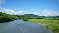 Mitsuishi River
 Shinhidaka Ainu Museum
 Monument to Shakushain's revolt


IMG_6337.jpg)
Mascots


Shinhidaka's mascots are Konbuman (こんぶマン) and Kobune-chan (こぶねちゃん). They are superhero siblings.[13][14]
- Kobuman is from Mitsuishi. He is usually active in events. He became mascot on February 2, 2013.[15]
- Kobune-chan became mascot on August 10, 2017. Like her brother, she is also usually active in events.