This is an archive of past discussions about Geography. Do not edit the contents of this page. If you wish to start a new discussion or revive an old one, please do so on the current talk page.
RfC: Should US Government Maps be used in the Geography and similar articles
The following discussion is an archived record of a request for comment. Please do not modify it. No further edits should be made to this discussion.A summary of the conclusions reached follows.
It's been less than 30 days, however, there have been no new !votes here in a couple weeks. In response to a request at WP:CR, I am closing this RfC.
Per our policies and guidelines, the determination of WP:CON is WP:NOTAVOTE. There is less than unanimity in this discussion. When this is the case, our policies and guidelines require the closer to close based on whichever argument is supported by "the predominant number of responsible Wikipedians" after first discarding arguments "that flatly contradict established policy, those based on personal opinion only, those that are logically fallacious, and those that show no understanding of the matter of issue" (see: WP:NHC).
A preliminary pulse check reveals that, in broad strokes, 5 editors support A, 2 support D or E, 1 supports E, 1 supports D or F, 1 supports D, 1 supports C, and two express other opinions.
The identification of consensus begins by finding areas of agreement. On that basis, I began with an analysis of maximum element frequency. This analysis produced the following adjusted results: 5 editors support A, 3 editors support D, 1 editor supports E, 1 editor supports C, and there are two additional opinions.
Next, to determine the view of "responsible" Wikipedians I conducted a census of which Wikipedians in this discussion were "responsible". To apply this term, I eliminated any Wikipedian topic banned on this subject, any editors who indicated they had been WP:CANVASSed to the discussion, as well as obvious WP:SPAs. This census produced no change in results.
Finally, I began the process of discarding !votes that are "based on personal opinion only" by eliminating all WP:VAGUEWAVEs, as well as any !votes invoking wording or phrases indicative of personal preference, or which made no attempt to invoke even a glancing reference to our policies or guidelines. This analysis produced no change in results.
"A" !voters, who constituted a plurality, appended various caveats drawn from different policies and guidelines to their !votes but which can be broadly summarized by User:Strebe who said that ” Maps likely to provoke controversy should be avoided unless suitable alternatives cannot be found or unless the purpose is to illustrate controversy.” and User:Jacobolus who objected to the idea of a priori rejection but held out the idea that individual maps might be avoided in specific circumstances. CMD, who was one of the “no letter !voters” cited our WP:PERTINENCE guideline to essentially (albeit not precisely) mirror the caveats largely applied by the “A” !voters. One of the "D" !votes also opined a less than affirmative declaration noting WP:PRIMARY but also holding out that, in some cases, PRIMARY might be acceptable.
At the end of the day, there was a fairly wide berth of agreement, though editors signaled positions that often agreed with each other using different survey letter choices.
In response to the RfC question Should recent, US-government published maps be included on this and similar pages and why?, the consensus is that there should be no a priori acceptance, nor a priori rejection, of the validity of maps produced by the U.S. Government and the use or non-use of any specific map should be done on a case-by-case basis taking into account relevant policies and guidelines, including but not limited to WP:PRIMARY, WP:PERTINENCE, and WP:NPOV. Chetsford (talk) 16:54, 1 April 2025 (UTC)
Should recent, US-government published maps be included on this and similar pages and why?
A: Yes. Please add any conditions required.
B: Yes, but only those prior to 2016 or other threshold.
C: Avoid government published maps (US or otherwise)
D: Avoid any political maps
E: No. Please state why and what sources are preferable
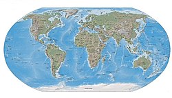
A derivative of the 2015 and 2021 CIA maps authored to avoid NPOV issues SVG
UN 2020 World Map SVG
Boggs eumorphic projection
Polling (RfC: Should US Government Maps be used in the Geography and similar articles)
A. (With the caveat that a US government-published map is not necessarily the best map in every instance, so each map can be taken on its own merits). In prior discussion, I saw no reason to prefer other governments' political maps to US ones (basically every country has an idiosyncratic combination of recognitions/stances on partially recognised states and border disputes). The same goes for political maps from other sources. For example, whereas US-government maps now don't include Western Sahara, UN ones don't include Kosovo. I see no reason to exclude either body a priori as a source for an illustrative map. The only consistent alternative is D and I consider this unnecessarily restrictive. Attribution of the source of the map is sufficient. Samuelshraga (talk) 08:05, 13 March 2025 (UTC)
D (first option) All political maps (US or otherwise) implicitly push the interests of the producer. In Wikipedia articles we don't just slap images anywhere that they might look pretty. Images are supposed to be used to provide visual illustration of the content of the section they're in, or the page as a whole (in the case of those in infobox). In this circumstance, given the content matter, a political map is simply not needed in the fundamentals section (where it currently sits) when a topographical map will serve just as well for illustrative purposes. Therefore, I would recommend we use the Boggs eumorphic projection (displayed to the right). If we are to use a political map then E (second option) we should use the UN world map (displayed to the right). While not perfect, as others have stated in pre-discussions, it at least is not implicitly pushing the interests of any particular nation state. TarnishedPathtalk 09:03, 13 March 2025 (UTC)
None of the above, the key issue for image choice is MOS:PERTINENCE, and this very broad question does not address it. Maps are of course relevant to Geography, but the particular map (or other image) choice will depend on the content it is meant to illustrate. Declaring a certain map is not relevant for the topic of Geography, including its similar articles, does not make sense. Even if it doesn't fit on the current article, it may do on a future version, or fit on a similar article. TarnishedPath is correct the map is mostly decorative in its current position, and I have mentioned elsewhere that just using a topographical map there would avoid that particular issue, however, that is not the RfC question. We cannot D, "Avoid any political maps", across Geography and similar articles. That would mean an inability to illustrate quite a basic concept. Nor should we likely avoid C, as all publishers make choices (at least a government's choices are usually easy to explain). What should be done is that maps are chosen per MOS:PERTINENCE, and attributed to a particular origin in captions, if needed. CMD (talk) 09:50, 13 March 2025 (UTC)
I agree with all this - would it be reasonable to summarise your position as saying that recent US-government maps shouldn't be excluded, but that discussions of inclusion will be specific to each article and the part of the article where they take place? Samuelshraga (talk) 09:54, 13 March 2025 (UTC)
Thanks, that is a reasonable summary. I would add as an addendum that I see no strong advantage to the USA map illustrating the current Fundamentals section, compared to other maps. I would even suggest a world map may not be the best scope to illustrate mapping fundamentals. CMD (talk) 10:16, 13 March 2025 (UTC)
D/F Government published maps should be used only to show the position of that particular government, which often is not the majority view, let alone one that could be stated in wiki voice per the NPOV policy. (t·c) buidhe 03:22, 12 March 2025 (UTC)
A My opinion is stated in detail across the numerous talk pages, but I'll state it here again. Official government maps should be used with proper citation/attribution and date. Unless we have a particualar reason to use historic maps, I think we should use the most up to date set of boundaries from our chosen, and update as they come out. These boundary files should not be modified by editors as that would be either POV or Original Research (depending on how you frame the redrawing of lines), and editors should not selectively update boundary files. While the issue here is largely about the U.S. changing it's stance on the borders of Morrocco and existence of Western Sahara, Russia, China, and India have stances that are at least as controversial when it comes to borders. That said, I'm not particular about which governments lines we use, and think the United Nations ones might be the least likely to cause controversy between nationalists with competing opinions on which set we should use, based on conversations above. For various thematic maps though, the boundaries should match the dataset we are showing (i.e. if we're showing population density based on the CIA world factbook, we should use U.S. boundaries). GeogSage (⚔Chat?⚔) 14:42, 13 March 2025 (UTC)
A Any map from a WP:RELIABLE source could be used circumstantially, including maps produced by the US government. Maps likely to provoke controversy should be avoided unless suitable alternatives cannot be found or unless the purpose is to illustrate controversy. Whether we ought to ban maps from the US government seems like a terribly uninformed question: Enormous quantities of USGS topological maps (for example) are in the public domain and highly suited to Wikipedia use because they are free of copyright, authoritative, and often the only source. The question really seems to be about political maps of the world from the US government, so the question seems ill-posed. MOS:PERTINENCE has been brought up, and I agree with the points made about that. However, where a political map of the world is needed, the US government is as authoritative and valid a source as any other, and I cannot express my disagreement strongly enough about those who advocate messing with maps to doctor them up with their own interpretations of how they ought to show the political world. I’m sure they feel righteous about it, but everything about that enterprise is contrary to Wikipedia policy. It is fine to explicitly state on the caption that the boundaries shown are from the point of view of the US government. There isn’t any answer to this particular problem that is “correct” or that won’t offend a lot of people. This is not to say we ought to preferentially choose a US governmental map; it really is about pertinence. —Preceding unsigned comment added by Strebe (talk • contribs) 17:36, 13 March 2025 (UTC)
A, for educational/aesthetic reasons, considering the alternatives. Every map has a bias as it cannot represent the infinitely complex reality. For instance, the UN map above shows the Chagos Islands as belonging to Mauritius which is quite controversial. Arunachal Pradesh is shown as a separate entity with solid boundaries even though it's de facto controlled by India. Since there is no single truth and every POV won't be liked by someone, it's better to use the CIA map that looks the best and shows topographical features that are arguably more important than borders. Needless to say we should attribute it clearly. D could also be a good option if we can find a suitable map. Alaexis¿question? 07:54, 12 March 2025 (UTC)
My opinion doesn't neatly fall into any of the letters, but I'll give mine anyway. I am leaning towards E with using a historical map to illustrate the geography page. I have no opinion on which historical map to use, but I feel that a historical map would probably best represent the subject here. However, if editors decide that they want a current map, my first preference would be the UN map, then the most recent CIA map, in that order. I am against using user created maps here (such as the derivative CIA map listed above) as I prefer the maps to be from published reliable sources. In general, I would prefer the CIA map as a last resort and have the most recent one in the article. I would also be in favor of having the caption on the map to state the source of the map as well as the year the map was published. Interstellarity (talk) 01:03, 14 March 2025 (UTC)
D/E With one caveat: I do think the UN map would be the "least" political and therefore appropriate to use. To those supporting, there is also a question as to whether the US government is currently a "reliable" source. SportingFlyerT·C 11:38, 14 March 2025 (UTC)
I think if there's a question about whether the US government is reliable in general, for the purposes of maps it has published it would be covered by Wikipedia:RSOPINION so there is no reliability concern (leaving aside questions of "less" or "more" political maps, which I think many editors have covered). Samuelshraga (talk) 08:59, 17 March 2025 (UTC)
D by definition these are primary sources (that is all political maps),. as such they are claims, and so should not be stated as facts. So it all depends on context. Slatersteven (talk) 12:35, 14 March 2025 (UTC)
C, the UN map should be prioritised. Haven't seen any convincing arguments for why we should use the US' map rather than other countries', seems unnecessarily POV. Kowal2701 (talk) 23:19, 14 March 2025 (UTC)
A Any map which meets Wikipedia standards (WP:RS, WP:NPOV, etc.), has acceptable license without copyright concern, and is legible, reasonable attractive, etc. is fine for inclusion in Wikipedia. The best available map should be used for any particular context, and there's no a priori reason to reject them based on the creator; rejecting all products of large governments for non-specific reasons is a good way to just eliminate valuable images that Wikipedia volunteers don't have the capacity to completely remake / aren't worth volunteer time that would be better spent on making new work instead of pointlessly duplicating existing work in the name of ideological purity. Maps should instead be evaluated by their content (including visual style). The particular maps under discussion here seem completely fine, and no good reason has been given for rejecting them. Indeed this entire exercise seems like a time waster motivated by political ideology without any concern for Wikipedia authors or readers. If US-government produced maps stop meeting Wikipedia standards (for example, a map on which the Gulf of Mexico is labeled "Gulf of America" would not satisfy WP:NPOV) then they should be rejected on those grounds. –jacobolus(t) 21:45, 16 March 2025 (UTC)
F As others have said maps needs to meet the standards of RS and NPOV, just like any other content. As the most recent US govermental map doesn't meet those standards it shouldn't be used anywhere but articles were US political opinion is due for inclusion (Oppose A). If a map showing "Gulf of America" wouldn't be acceptable, then a map showing that Morocco fully owns Western Saraha (not supported by RS, not something that is defacto on the ground, and is in the map due to US diplomatic concerns alone) is equally unacceptable. Govermental sources (regardless of the country) should be attributed to that government and are only due where the opinion of that government makes sense. Use of UN maps is one possibility, but user generated maps (which are already used on thousands of article) that can be shown to be based on RS are another option. -- LCU ActivelyDisinterested«@» °∆t° 13:00, 19 March 2025 (UTC)
Could you please explain what you mean when you say that showing all of Western Sahara as part of Morocco is not supported by RS?
Or in general why the UN map omitting Kosovo is more acceptable than the US map omitting Western Sahara (or renaming the Gulf of Mexico)? I don't understand what role RS should be playing here as you describe them in your !vote, but it seems to me that Kosovo's claim to existence is at least as well sourced, is a de facto country on the ground and is only omitted from the UN map due to various political considerations (Chinese and Russian ones). So I don't understand the difference between the two cases that you posit. Samuelshraga (talk) 12:25, 1 April 2025 (UTC)
Kosovo has limited international support, which is why it's missing from the UN map. The same is true of the status of Western Sahara, they are in fact in the same situation. A map showing the contested borders of Kosovo, Western Sahara, the India / Pakistan / China border, Israel / Palestine, would be better neutral than any map showing one side of those disputes. If you believe that a map failing to show the situation in Kosovo is unacceptable, then why would you find one failing to show the situation in Western Sahara as being acceptable? Reliable secondary sources that show those disputes are preferable to one primary governmental source. Finally note I barely mentioned the UN map only that it could be better than a map from one particular government. Maps are political, the lines don't actually exist on the ground, so all maps will have political considerations. But that doesn't mean we should accept one that only shows one view point, that would go against NPOV. At least the UN map is made from multiple political viewpoints, even if it is still flawed. -- LCU ActivelyDisinterested«@» °∆t° 13:35, 1 April 2025 (UTC)
Discussion (RfC: Should US Government Maps be used in the Geography and similar articles)
I still think it's unfortunate that the phrasing of the RfC is about inclusion rather than exclusion. While editors might have reasonable policy and content based arguments as to why the US world factbook map that was the subject of the underlying discussions can and should be replaced, I am concerned that an outcome other than A will lead to blind excision of US maps. Given that the RfC is framed in general terms about this and similar articles, and not about one map in particular, I hope that people will contribute on the general acceptability of maps for those spaces, and not for whether we should add/maintain specific instances of US maps in particular parts of these articles. Samuelshraga (talk) 10:03, 13 March 2025 (UTC)
The wording of an RFC doesn't necessarily dictate the direction in which discussion goes. Any closer should always look at the contents of the pursuing discussion to determine consensus and not merely what editors chose to !vote. I've seen closers of RFCs determine consensus to be an option that was never mentioned in the RFC question purely on the basis of the discussion that occurred. TarnishedPathtalk 10:38, 13 March 2025 (UTC)
Pinging @Simonm223, @Sean.hoyland and @Slatersteven as editors involved in prior discussions. Sorry I was double checking editors who I pinged and I don't know how I missed you all. Some voodoo to do with your usernames starting with S? TarnishedPathtalk 12:21, 14 March 2025 (UTC)
Just for sake of transparancy, want to mention that I posted a link to this on Wikipedia talk:WikiProject Maps. I hope we can get some editors who are interested and educated on this topic, especially as it relates to Wikipedia policy, into the discussion. GeogSage (⚔Chat?⚔) 14:43, 13 March 2025 (UTC)
Sorry I didn't think of that. I just posted at the only project that was mentioned at the top of this page. TarnishedPathtalk 11:36, 14 March 2025 (UTC)
No reason to be sorry, you're doing great and I appreciate the help! GeogSage (⚔Chat?⚔) 16:38, 14 March 2025 (UTC)
@SportingFlyer, I've stated this a few times in various talk sections but figure I should address it in the RfC as it has been brought up. I believe governments are always good sources for the official stance of the government, and the official borders are a reflection of the countries stance on the issues. When it comes to things like objective scientific research, or the reliability of historical narrative, we can debate the reliability of governments, but China, Russia, North Korea, Iran, France, England, India, Pakistan, Argentinia etc. all publish official maps, and those maps are all accurate reflections of those countries official stances. The UN map is a compromise, but the Super power and Great power countries are all pushing their official views on it more then Middle power countries. This is why we cite and date, because saying a country is wrong or unreliable about their own views is a very odd position to take, like telling a person they are wrong about their favorite color. I should note on the specific issue that has brought this map into controversy, the existence of Western Sahara, Trump made the change during his last term, and Biden did not reverse it. This makes me think it is not very controversial between the U.S. political parties. There isn't an objective reality or correct set of borders we can use, but not using political maps at all is a handicap. GeogSage (⚔Chat?⚔) 16:49, 14 March 2025 (UTC)
We don't need to tell a country that they are incorrect about their views, we simply need not have material that is in large part a reflection of their views on a page where the subject matter is not even peripherally about their views. TarnishedPathtalk 02:12, 15 March 2025 (UTC)
This is a fair point, the main issue is that on a geography page, one of the most basic tools used in human geography are political maps. An up to date political map would be an elementary way to show the basic human geography of the planet. The page has had a map on it since at least 2005 that showed political boundaries, so this isn't exactly an outrageous novel opinion that the geography page should include one (I do think we should include a contemporary map somewhere, regardless of source). The map from 2005 Physical world used 2004 CIA World Factbook boundaries (see attached). While there is a case to change to the UN map because it isn't more one countries view then another, I definitely am of the opinion that the sudden interest in what source we're using is thinly veiled political opinions. The question I'm responding to is "whether the US government is currently a "reliable" source," to which I'd say that the U.S. is always a reliable source for boundaries showing the official U.S. stance. Furthermore, this discussion should be had regardless of who is in office, and should have been had in 2004/2005. Framing the discussion as one that should be had now because of a change in reliability of the underlying source is going to open an entirely separate can of worms, which I'd rather not try to deal with. I don't want to have a discussion about the Trump administration and their policies masked behind a discussion about the best source for up to date map boundaries. GeogSage (⚔Chat?⚔) 05:21, 15 March 2025 (UTC)
@User:jacobolus, largely I agree with your statement, but am curious about your example of "Gulf of America" not being NPOV has me a bit confused. Place name changes are not really that big of a deal and happen all the time, what we call a body of water isn't that important. Different groups/countries can have different names for the same feature without going to war. For example, South China Sea, West Philippine Sea, and Natuna Sea, or Persian Gulf and Arabian Gulf. Border disputes have some serious implications for people who live in that location. I don't know if I understand why you're more concerned with the "Gulf of America" place name then the question of if Western Sahara is part of Morocco or if Kosovo exists. —Preceding unsigned comment added by GeogSage (talk • contribs) 00:24, 17 March 2025 (UTC)
I think this type of politicized output (or more generally blowback at the isolationism and anti-intellectual moral crusading of the Trump administration) is likely the motivation for this discussion. When those political decisions start having a clear effect on the output, then we should question individual decisions. The "Gulf of America" nonsense has had real deleterious effects, for example as far as I can tell the USGS earthquake tracker has had many of its features summarily broken/deleted because the teenagers at DOGE responsible for political censorship didn't have the technical competence/patience to figure out how to change "Gulf of Mexico" to "Gulf of America" on the map imagery so just removed "noncompliant" map layers instead. While it isn't perfect, and like any source should be compared with other sources, for a long time the World Factbook has been a relatively neutral and reliable source of demographic information about places all around the world. But I could certainly imagine that changing if the current US presidential administration starts applying its heavy handed political pressure on the staff responsible for publishing it. If Wikipedians find examples where maps (or tables, diagrams, statistics, etc.) put out by US federal government agencies have been politicized, then those should not be uncritically passed off in Wikipedia's voice as authoritative. But rejecting everything ever made by the US federal government because we don't like some recent politics seems like throwing out the baby with the bathwater. –jacobolus(t) 01:47, 17 March 2025 (UTC)
Thanks for the answer, I'm still struggling a bit to understand the view, but I think it's a bit clearer. In my opinion, all map boundaries, labels, and content published by a government is a political decision. The World Factbook has had many controversies, and several are listed on the page. Picking and choosing which political decisions to include or exclude is taking a stance, and the official government name for mountains and water bodies is really just cheap political hokum and bunk to pander to the base. Not using a map because of that doesn't seem very NPOV. GeogSage (⚔Chat?⚔) 02:40, 17 March 2025 (UTC)
Anyone who makes any map is making tons of political decisions. There's no a priori reason to think that the decisions made by an arbitrary Wikipedian will be more neutral just because they haven't declared themselves to be funded by a national government. Most (all?) Wikipedians have political biases, an unfortunate number seem to organize their editing around promoting particular political agendas, and some are surely even secretly being paid for their work. The decisions made by any mapmaker should be open to criticism and discussion from other Wikipedians, but if a map was created by a government that doesn't, a priori, mean that it will do a worse job aligning with Wikipedia policies and goals than a map created by a pseudonymous community member. In my opinion we should be willing to use maps created under a free license irrespective of source, optionally adapted to better align with Wikipedia's needs. –jacobolus(t) 05:25, 17 March 2025 (UTC)
@User:ActivelyDisinterested, what do you mean by user generated maps? If it is a map based on some official boundaries with data by that source, that is one thing. Combining seperate boundary files, or generating a new one entirely to make a new one that better fits a particular world view, would be OR in my opinion. If such maps exist with user synthesized boundaries from multiple sources are wide spread, they should be deleted in the same way a page that "cannot possibly be attributed to reliable sources, including neologisms, original theories and conclusions, and hoaxes" should be deleted. GeogSage (⚔Chat?⚔) 16:09, 19 March 2025 (UTC)
I mean the type of maps that are commonly used in the infoboxes of most country articles or similar. -- LCU ActivelyDisinterested«@» °∆t° 16:18, 19 March 2025 (UTC)
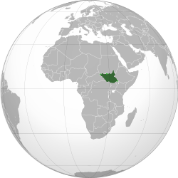
For instance the map of the boundaries of South Sudan, which correctly shows disputed territories. The boundaries of a country are usually denoted by law or international treaty, so an editor creating such a map wouldn't be engaging in OR. -- LCU ActivelyDisinterested«@» °∆t° 16:21, 19 March 2025 (UTC)
Looking at the infobox maps for Mexico, MEX orthographic and the United StatesOrthographic map of the United States, both list Natural Earth Data as their source (from my understanding, these are basically the files supported by North American Cartographic Information Society, but I haven't worked with them extensively) fairly clearly. We could add Natural Earth Data as a possible acceptable source in addition to the UN, as they seem to be taking an academic approach to the problem. The map on South Sudan you point to is disturbing in that I can't clearly find where they found the boundaries they are using South Sudan (orthographic projection) highlighted. On Wikimedia, it links to several other files on Wikipedia, and many are modified versions of other files that are not well sourced. Some list the source as "own work" which is either unacceptable OR, or not properly citing the original cartographer (probably more likely). I would consider this no different from writing stuff without a source, and think they should be replaced by maps that are properly sourced to somewhere. This is the kind of wide spread problem we have on Wikipedia that seems to have been ignored when it comes to cartography. GeogSage (⚔Chat?⚔) 16:36, 19 March 2025 (UTC)
Something being marked as "own work" is relevant to copyright, as in the uploading owns the copyright of their wonderful work. It is irrelevant to matters of OR, unless your interpretation of WP:OR is that all content that isn't a 1-1 match to a source is OR. -- LCU ActivelyDisinterested«@» °∆t° 16:45, 19 March 2025 (UTC)
A set of boundary files are either properly attributed to a reliable source, or they are original. When it comes to boundary files, I absolutely think they need to 1-1 match a source to avoid being OR. Boundary files need to be cited in the same way that an exact quote needs to be cited to avoid being plagiarism (a real problem in cartography is people feel entitled to the work of cartographers without attribution). A map that does not cite a source is either the view of the editor who created it, and their view alone, or plagarism. I have no idea who made the original files that the South Sudan map is based on, what their biases are, or what material they used to draw these lines, and that is a huge problem that is widespread on the site. GeogSage (⚔Chat?⚔) 16:58, 19 March 2025 (UTC)
Here is an example of a map I made as "Own Work." The description in it says "Based on data from the CDC/ATSDR Social Vulnerability Index, this bi-variate choropleth map compares the percentage of the population over 65 and the population 17 and under in counties within the Contiguous United States of America. The map was created in ArcGIS Pro. Source: Centers for Disease Control and Prevention/ Agency for Toxic Substances and Disease Registry/ Geospatial Research, Analysis, and Services Program. CDC/ATSDR Social Vulnerability Index, 2020, Database US Counties https://www.atsdr.cdc.gov/placeandhealth/svi/data_documentation_download.html"
The thematic map itself is my "own work", but the data source is given, and if you go to that link, you can find the unmodified dataset, and if you have ArcGIS Pro or similar software, could easily recreate the map itself. If I wanted to, changing the values is as easy as editing a table in excel, changing the borders is as easy as drawing a line in paint, but making those changes would not be appropriate.
Bi-variate choropleth map comparing the estimated percent of the population 65 and older and 17 and younger in the Contiguous United States by county, 2020GeogSage (⚔Chat?⚔) 17:05, 19 March 2025 (UTC)
Yes they should comply with V as well as NPOV, and I'd fully accept that many of the files used in articles fail those requirements. But my point that "own work" relates to copyright, not whether the work is OR stands. -- LCU ActivelyDisinterested«@» °∆t° 00:42, 21 March 2025 (UTC)
I see what you mean, it's been a while since I uploaded on Commons and I never spent much time working with it. The issue is when the only source we have for a map is "own work," there needs to be proper documentation just like any other set of facts, we can't just spit out country land area and population without a proper citation, borders are not different. It should be easy for someone who isn't afraid of QGIS (or something like it) to recreate a map on Wikipedia to check if it matches the source data. Ideally, the uploader should include the software they used in the description as well. GeogSage (⚔Chat?⚔) 04:38, 21 March 2025 (UTC)
Completely agree that user generated maps should have proper sourcing, they need to comply with policy as much as any other content. -- LCU ActivelyDisinterested«@» °∆t° 11:38, 21 March 2025 (UTC)
Do you think the map on the "South Sudan" page is adequately sourced? GeogSage (⚔Chat?⚔) 17:25, 21 March 2025 (UTC)
unless your interpretation of WP:OR is that all content that isn't a 1-1 match to a source is OR: That is the problem. It is either WP:OR or WP:SYNTH or both. Hence we keep having these massive edit wars and debates because certain people think their own view of boundaries and political divisions are inherently right or unbiased and thereby trump Wikipedia rules. The only way out of that is, surprisingly, to follow the rules. Natural Earth Data is an excellent source, by the way. Strebe (talk) 17:07, 19 March 2025 (UTC)
Thanks for the 2nd opinion on the National Earth Data! I've only heard of it in passing, I've never used them for a source in a map but am adding them to my personal data horde and lectures as we speak. In my IRL job, the research I've done on Africa was using state department datasets, and therefore needed state department boundaries. I'm glad to find another source to add as an option. I'm not sure where we could do this, maybe Wikiproject Maps, but some sort of basic cartographic conventions and standards should be established, with a list of acceptable datasets for boundaries and place names. The project is in desperate need of a cartographic task force to clean things up. GeogSage (⚔Chat?⚔) 17:42, 19 March 2025 (UTC)
A nice thing about the NED is that the databases include attributes for disputed boundaries. Careful attention to them — showing boundaries as disputed, rather than as “fact” — can preempt a lot of the NPOV noise. It’s no cure-all, of course, since many ideologues, particularly from national viewpoints, do not acknowledge that a boundary is disputed and therefore consider marking it as disputed to be a point of view. Strebe (talk) 01:08, 20 March 2025 (UTC)
That does sound nice! In the various talk pages, there have been calls for "neutral" academic sources. While I would never agree a source is truly neutral on political maps (even saying a boundary is disputed is a stance on it, as several countries assert that the land is theirs and reject the idea of a dispute entirely), this might be one that satisfies that request. GeogSage (⚔Chat?⚔) 01:40, 20 March 2025 (UTC)
Noting that I've already argued for a topographic map and that if we are to use a political map that I've argued for the UN one, pages use user generated images all the time and there is never any argument of WP:OR in regards to those. The important part of the usage of images is that per MOS:IMAGEREL[i]mages must be significant and relevant in the topic's context, not primarily decorative. TarnishedPathtalk 20:36, 19 March 2025 (UTC)
Maps are not normal images, they are models of reality used to communicate spatial information (especially if we subscribe to the Map communication model). As models, all maps are distortions/simplifications of reality, and to avoid misinformation there are established cartographic conventions that should be followed. Map creation follows the Cartographic design process, which involves planning, data collection, implementation, and production. If we are not citing our sources for data collection, and instead using user generated boundaries, we are creating original data for the map. As maps are used to communicate ideas, user generated boundaries are no different then typing an original idea into a Wikipedia page. The fact no one has dealt with this is not a reason to continue doing it. A bad map is worse then no map at all, just like misinformation is worse then no information at all. Any unsourced user generated boundaries should be removed. GeogSage (⚔Chat?⚔) 21:04, 19 March 2025 (UTC)
The discussion above is closed. Please do not modify it. Subsequent comments should be made on the appropriate discussion page. No further edits should be made to this discussion.
Implementing results of RfC
The RfC is now closed and the consensus is " there should be no a priori acceptance, nor a priori rejection, of the validity of maps produced by the U.S. Government and the use or non-use of any specific map should be done on a case-by-case basis taking into account relevant policies and guidelines, including but not limited to WP:PRIMARY, WP:PERTINENCE, and WP:NPOV" as can be seen above. To implement this, we still need to swap a map and remove the template for neutrality. @Interstellarity, I believe the updated map you proposed originally should fit this consensus for now if you want to update it. We can discuss other options, like the UN map or something else (I'm leaning towards the Natural Earth Data after following the discussion personally). Once done, could someone remove the neutrality template? Based on my involvement I'd prefer not to be the one to do so. GeogSage (⚔Chat?⚔) 04:41, 2 April 2025 (UTC)
Isn't that the one that started this whole discusion, the one that isn't NPOV compliant? I don't see how using that map would be implementing the RFC close. -- LCU ActivelyDisinterested«@» °∆t° 20:55, 2 April 2025 (UTC)
CIA World Physical Map (2023)
The one we currently have is a product derived from multiple maps, and in my opinion (as a professional cartographer/geographer, although it's Wikipedia, so I know my credentials are not an argument), based on the Wikipedia policies, is not NPOV compliant, is WP:OR, and I would classify it as misinformation. The map Interstellarity tried to include is the U.S. government's map. Updating the current map has been blocked since February 2024, at least, and that has been what caused the whole RfC. The neutrality notification was put in place by the author of the current map, who was blocking updates that showed changes in the U.S. official diplomatic policy. The Consensus is "there should be no a priori acceptance, nor a priori rejection, of the validity of maps produced by the U.S. Government." As I understand it, that means we can use U.S. government maps and there should be no reason to avoid updating the current map to a more up-to-date version. I don't think that the RfC close adequately addressed users synthesizing a map from multiple sources for political reasons. If we want to change the source of the map to a U.N. one, or something else, we can. Until then though, I think the tag can go and map replaced with one that accurately reflects the source. GeogSage (⚔Chat?⚔) 21:58, 2 April 2025 (UTC)
The close says the maps should be considered on a case by case basis taking into account the relevent policies. You understanding of the close is wrong. It says US maps can be used, but the close doesn't say they have to be used. The policy based arguments against the map haven't changed. If you believe the old map is equally deficient that would be grounds for removing the old map, but the new map is still has the same issue. -- LCU ActivelyDisinterested«@» °∆t° 22:33, 2 April 2025 (UTC)
The current map violates WP:OR and WP:SYNTH. It needs to go. We’re not going to get anything that doesn’t express a viewpoint (which is inherent in a map), but the other candidate maps at least don’t run afoul of the other guidelines. Strebe (talk) 22:38, 2 April 2025 (UTC)
I agree with implementing the map above. Interstellarity (talk) 01:04, 3 April 2025 (UTC)
The map above is fine among the choices offered, the arguments about NPOV somewhat ignored that there is no NPOV map. That said, this again feels constrained by assumptions that haven't been discussed. Why is a world map being used at all? What is it conveying from the section it is in? CMD (talk) 06:12, 3 April 2025 (UTC)
I'm not saying any map is without NPOV (no one did), but that just because that's true doesn't mean we should use any map without qualification. If that was true using Russia's map showing ownership of parts of Ukraine in the Ukraine article, or an Israeli map showing ownership of the Golan heights in the Syria article, would be acceptable. Finding a map that best suites the article is still a valid option. The argument is that a map showing the US diplomatic opinion of the world isn't the right map for the Geography article. -- LCU ActivelyDisinterested«@» °∆t° 10:55, 3 April 2025 (UTC)
Understandable, I'm open to any other map we can give clear citations to, but am concerned with replacing the current one and the tag until then. GeogSage (⚔Chat?⚔) 15:11, 3 April 2025 (UTC)
Plenty of people said X or Y map wasn't NPOV, but there was no follow up on the lack of an NPOV map. All very well saying what country's diplomatic opinions someone might disagree with, but that is not helpful unless it comes with a statement of what the "right map" is: which country's diplomatic opinions people want to show and why. CMD (talk) 15:38, 3 April 2025 (UTC)
Absolutely no map could be better than a NPOV map. If the only map we had showed the British empire still existing, no map would definitely be better. We should use a geographic map, rather than a political one, or as others pointed out the UN map. It has it's problems, but at least represents the view points of a multi-national organisation rather than one particular government. -- LCU ActivelyDisinterested«@» °∆t° 16:38, 3 April 2025 (UTC)
A political map is just a map that shows geographic boundaries of countries, states, etc. I'm not sure what you mean by "geographic map," except maybe a physical map showing only natural features without any borders. This makes it impossible to illustrate very important geographic concepts, like countries and borders. The RfC states there is not an "a priori rejection" of U.S. Government maps. We are currently using a product based on U.S. Government maps, and have for over a decade, we're just updating it to the most current one. If we want to change the source we use, we can discuss that, but it should be noted again that there is no such thing as a NPOV map, this is literally the theoretical foundation behind most of Critical cartography, and is an active area of cartographic research. From a quantitative perspective, looking at the Modifiable areal unit problem "the areal units (zonal objects) used in many geographical studies are arbitrary, modifiable, and subject to the whims and fancies of whoever is doing, or did, the aggregating." There is not a POV that is Neutral when it comes to drawing lines on a map, just one that better fits the world views of editors making the arbitrary decision to choose one over another. GeogSage (⚔Chat?⚔) 17:10, 3 April 2025 (UTC)
There's an article for Political Geography (which doesn't even have a map), while the general understanding of geography would be the physical features of the world. The first sentence of the article even points towards this, ... is the study of the lands, features... I'm not sure why you mention that part of the RFC here, but the full statement is there should be no a priori acceptance, nor a priori rejection. And again I have never said there is a non-NPOV map, it's not my argument, and has nothing to do with my argument. But choice of a map is not arbitrary, and is (as per the RFC close) something that has to comply with policy. Having a map that includes multiple view points is by definition less POV than one that is solely based on one view point. -- LCU ActivelyDisinterested«@» °∆t° 17:30, 3 April 2025 (UTC)
Which view points would you prefer to include? CMD (talk) 17:46, 3 April 2025 (UTC)
I'm not sure how to respond to this, as it's so reductive. I would prefer a map that isn't solely based on the opinion of the US goverment, and have suggest two different options in my last comment. Why should we solely represent the opinion of the US government in an article that is globally relevant? -- LCU ActivelyDisinterested«@» °∆t° 17:53, 3 April 2025 (UTC)
The two different maps you pointed out were a "geographic map", which isn't specific enough to figure out the meaning, and a "UN map", which does not present multiple view points. I find it hard to link these to the "map that includes multiple view points", so I asked what sort of viewpoints you meant. The inclusion of a single map does not mean an article solely represents the US government, so that is a bit of a red herring. CMD (talk) 02:24, 4 April 2025 (UTC)
That political geography article really needs to be expanded, the state of geography articles on Wikipedia is depressing, and a map would certainly be an improvement. That said, the lede of this article is: "Geography (from Ancient Greek γεωγραφία geōgraphía; combining gê 'Earth' and gráphō 'write', literally 'Earth writing') is the study of the lands, features, inhabitants, and phenomena of Earth. Geography is an all-encompassing discipline that seeks an understanding of Earth and its human and natural complexities—not merely where objects are, but also how they have changed and come to be. While geography is specific to Earth, many concepts can be applied more broadly to other celestial bodies in the field of planetary science. Geography has been called "a bridge between natural science and social science disciplines."" Physical geography is not the "general understanding of geography," Human geography and Technical geography are both major components of the discipline. Features on the Earth's surface can be human or "natural." Reducing it to just "natural" landforms is not in line with any of the major views or organizations of the discipline. I think that the full text of the lede makes this pretty obvious, and it feels like you're misrepresenting the text to push an argument that is not supported by cherry picking that small section of the lede sentence. Back to the main point of the map, fundamentally, the map we have now is unacceptable, and we have used the CIA World Factbook for over a decade. Updating the map to the latest version should not be controversial, if you have a map you'd prefer we use, we can discuss that, but until we have consensus on a new source we should update the one we've been using. As long as we cite where we got the border file from (And we should do that in the figure caption), we are just giving an example of an up to date political map used by the U.S.. GeogSage (⚔Chat?⚔) 20:45, 3 April 2025 (UTC)
It is an updated political world map showing the US diplomatic position. It's controversial because the situation in the world has changed in the last ten years. -- LCU ActivelyDisinterested«@» °∆t° 20:57, 3 April 2025 (UTC)
I don’t pretend to know what a “general understanding” is, and I’m surprised you do or think you do, but “geography” just means “physical features” is false, which is why we have the terms “physical geography”, “topology”, “physiography” and so forth when we want to talk about geography that’s only/mostly about physical features. Strebe (talk) 20:55, 3 April 2025 (UTC)
It's is part of Geography I accept, but that doesn't answer why the US diplomatic position should be given such a prominent position. -- LCU ActivelyDisinterested«@» °∆t° 20:59, 3 April 2025 (UTC)
You can litigate that after it replaces the map that the RfC determined must go. There is nothing a priori about the CIA map that prohibits its use other than WP:IDONTLIKEIT. We get get around to the slower process of replacing it with something generally more likable later, but since you already acknowledge that any map has an WP:NPOV problem, it’s just a matter of haggling to get to a good-enough solution. Strebe (talk) 21:29, 3 April 2025 (UTC)
I'm not saying any map is without NPOV (no one did)… You implied it with Isn't that the one that started this whole discusion, the one that isn't NPOV compliant? as if we should now go find one that complies with WP:NPOV, which you are now backpedaling to say doesn’t exist but somehow still resist the proposal for an immediate solution to the problem the RfC intends to solve. It is better to get rid of the map that the RfC censured now because it was agreed that it’s wrong, and to go with something else. If you want to litigate that something else once it’s in place, you are welcome to—indeed, most of us do seem to want something else—but that has nothing to do with the need to get rid of the artifact that the RfC demonstrated does not follow policy. The proposed replacement does not violate the policies that the status quo violates. The question isn’t WP:NPOV vs not in the case of maps; it’s a question how much point of view… and not even that, because there are many axes of point of view, and so there will be endless rounds of arguments over the “best” when there is no universal measure for that. But that would at least not be in violation of this RfC, unlike the status quo. Strebe (talk) 21:16, 3 April 2025 (UTC)
Exactly, I am not saying the CIA map has to be used, I'm saying the current map needs to go, and that based on the RfC we can use the CIA world factbook one until someone proposes something better. That said, I think we have many maps that are violating WP:OR and WP:SYNTH and no one has addressed it because they either don't know, or feel solving the problem would be too much work/too disruptive to the project. GeogSage (⚔Chat?⚔) 06:03, 3 April 2025 (UTC)
No the RFC basically says to use a map that that fits Wikipedia's policies, and that US govermental maps could fits that definition in some cases. It doesn't give permission to replace a bad map with another bad map. However it appears the consensus is for the new map, which is something that would support it's use. -- LCU ActivelyDisinterested«@» °∆t° 10:51, 3 April 2025 (UTC)
Just to clarify, we are replacing a bad map with a map from the U.S. Government. While the U.S. map might have a bias POV, it is not original research or a synthesis of sources created by an editor as far as I can tell. The RfC allows U.S. map in some cases, so it would be an improvement over what we have. GeogSage (⚔Chat?⚔) 20:47, 3 April 2025 (UTC)
Editors creating content isn't synth, otherwise articles would be synth. We have a bad map that's outdated, it's going to be replaced with a bad map that shows the single POV of the US government. Wikipedia uses many, many editor created maps, and they are viewed as acceptable. Some are worse than others but the creation of maps is still very acceptable. The RFC doesn't say anywhere that editor made maps are unacceptable. -- LCU ActivelyDisinterested«@» °∆t° 20:54, 3 April 2025 (UTC)
From WP:SYNTH: Do not combine material from multiple sources to state or imply a conclusion not explicitly stated by any of the sources. Similarly, do not combine different parts of one source to state or imply a conclusion not explicitly stated by the source. If one reliable source says A and another reliable source says B, do not join A and B together to imply a conclusion C not mentioned by either of the sources. This would be improper editorial synthesis of published material to imply a new conclusion, which is original research.WP:SYNTH is about drawing a conclusion that is not found in any single WP:RELIABLE source. Like any other content, a map could be synth or could be acceptable. The map under debate for replacement is synth: It takes from this source and from that source to construct a view its author favors. Strebe (talk) 21:04, 3 April 2025 (UTC)
Yes the old map is bad, that was the second sentence of my last comment. -- LCU ActivelyDisinterested«@» °∆t° 21:36, 3 April 2025 (UTC)
Comment: The current map is under CC license stating "This work is in the public domain in the United States because it is a work prepared by an officer or employee of the United States Government as part of that person’s official duties." The map is claiming to be a direct product of the U.S. government, despite being modified. This is a misrepresentation, and part of why I would classify this map as misinformation, not just synthesis or original research. GeogSage (⚔Chat?⚔) 21:32, 3 April 2025 (UTC)
The only change that appears to have been made was changing the capital of Kazakhstan, which was reverted later on. Admittedly it would have been better to upload the map with the changed capital separately, but as it was reversed calling it misinformation seems a bit strong. -- LCU ActivelyDisinterested«@» °∆t° 21:39, 3 April 2025 (UTC)
Can I ask what is so important about my acceptance? I have already stated hours ago that consensus appear to be for using the new map. I dont mind answering questions about my position, but is there a need for so much detail? -- LCU ActivelyDisinterested«@» °∆t° 21:41, 3 April 2025 (UTC)
Fair, sorry. Just trying to make sure we're not making changes that could lead back to disputes later. If you find a better map please propose it. GeogSage (⚔Chat?⚔) 03:09, 4 April 2025 (UTC)
My proposals don't seem acceptable, I'll continue to support alternative maps. If later on there is a better alternative then consensus might change. -- LCU ActivelyDisinterested«@» °∆t° 09:25, 4 April 2025 (UTC)
A 1730 map created by a Dutch geographer at a time when European knowledge of the world was expanding. The circles above and below the main map show heliocentric and geocentric conceptions of the solar system.
Given this discussion is about the "Fundamentals" section, I had a browse through the web for what different sites used to introduce Geography. Of those, I thought this book had a good idea in using the 1730 Stoopendaal Map of the World (right). Our article says "Geographers study the Earth's spatial and temporal distribution of phenomena, processes, and features as well as the interaction of humans and their environment". The 1730 map is a sort of world map, keeping that aspect. It also provides emphasis on the tropics and artic circles, which is an example of Earth's spatial and temporal phenomena distributed across different portions of the earth. It has ships, providing symbols of the interaction of humans and their environment, and one of the key purposes of maps. (I also appreciate to some extent the obviously unfinished map, as well as depicting different conceptions of the solar system. These feel like symbols of geography as an evolving science, although this is a bit more abstract.) This sort of more complex image seems a better way to illustrate the concept of geographic fundamentals. CMD (talk) 03:46, 4 April 2025 (UTC)
This is an interesting point, and I could possibly get behind it. I will point out, though, that the Stoopendahl map was an anachronism in its own time, presumably created more for nostalgia than to portray the state of European knowledge. The progenitors from the 17th century, such as from Visscher, would be better I should think. I’ve also mooted the idea of a map of an invented terrain constructed for didactic purposes, but I didn’t find any easily available that seemed to do the job well. There’s an 18th century map by Homann made for this, but this is the English article, not German. Strebe (talk) 05:43, 4 April 2025 (UTC)
Created to support Spanish ambitions to my understanding, but I'm presenting it as an example of my thoughts (illustrating "Geographers study the Earth's spatial and temporal distribution of phenomena, processes, and features as well as the interaction of humans and their environment") rather than saying it has to be that map. I also thought of a more abstract or invented map, but didn't see any in the examples I was looking at other than very stylised globes which felt more decorative than informative. I think an English map is preferable but not a dealbreaker, so if you have one in mind please add it here? CMD (talk) 06:04, 4 April 2025 (UTC)
Schematic and example of a space-time prism using transit network data: On the right is a schematic diagram of a space-time prism, and on the left is a map of the potential path area for two different time budgets.[1]
There are all kinds of maps for space/time, especially if we don't want to show the whole world, attached a map as an example. Fundamentally though, I think a map showing contemporary borders is useful. From a purely functional standpoint, political maps are one of the most basic and fundamental things we use in geography and I think failing to include one that is more up to date would be detrimental. When teaching human geography, I've been taught to start with a current map of the place we're discussing. I'm not against using historic maps, the article has several I have added and at least one that I uploaded myself, but these do not offer the same utility as a modern map. If needed, I can make something in Arc but I'd like a consensus on which boundaries to use first. GeogSage (⚔Chat?⚔) 06:23, 4 April 2025 (UTC)
This article isn't really discussing a place, it's discussing a concept. I'd be happy with a contemporary map that illustrated different aspects of geography, I raised that specific one as an example it seemed the best from various hits I found online. CMD (talk) 06:41, 4 April 2025 (UTC)
The close mentioned WP:PERTINENCE, and WP:NPOV as being considerations. To me that would heavily favour using a topographic map, if a map is to be used. Per WP:PERTINENCE Images must be significant and relevant in the topic's context, not primarily decorative. and per WP:WEIGHTNeutrality requires that mainspace articles and pages fairly represent all significant viewpoints that have been published by reliable sources, in proportion to the prominence of each viewpoint in those sources.
When there are so many competing political maps from differing major powers which contradict our best way to represent all significant viewpoints is simply not to go there. Further a map with borders simply doesn't have any significance or relevance to the section that the maps are placed in. While the close does state that we shouldn't rule maps in or out by virtue of the them being produced by the US government, that does not mean we should default to using US government maps either. We simply don't need to and a map with borders adds nothing more to the section than a map with no borders (e.g., Boggs eumorphic projection which are excellent resources as they are released with free licenses). TarnishedPathtalk 11:01, 5 April 2025 (UTC)
First to clarify, the image you linked is a mosaic of satellite images, not a Topographic map. Second, human geography is just as relevant to the discipline as physical geography, so showing human geographic features makes just as much sense as showing natural ones. Based on this comment, I moved the map to the section on branches were it is much more relevant then general fundamentals, and tried to improve the caption to better link it to the text. I also deleted the purely political map, in favor of the one showing physical features that also had borders on it. I think this placement in the article looks better, is a bit more logical, and reducing the number of images makes the article a bit cleaner. A map of countries is extremely important to the concept of geography, and if we can't show countries on the main geography page, then there are some serious site wide discussions we need to have about maps on the project overall. The most common approach I've seen to teaching World regional Geography is to start with a political map, and country names and location are one of the common things that come to mind for average people when they think of geography. As for the projection we use, the Boggs eumorphic is fine, I'm more of a Winkel tripel projection fan myself. The issue of projection is another serious thing that needs to be discussed, especially as they relate to thematic maps used on the project. We can use the Boggs eumorphic projection to show sovereign states as well as satellite images. There are literally volumes of literature on map ethics, best practices, and conventions that are essentially ignored on Wikipedia. I'd really like to set some sort of basic cartographic standards and apply them consistently across the project, including which boundaries and projections are appropriate in various contexts. GeogSage (⚔Chat?⚔) 04:22, 6 April 2025 (UTC)
Just noting that:
The RfC closer didn't say anything about which map to use. Their close comment doesn't tell us anything that we didn't know, i.e., the use or non-use of any specific map should be done on a case-by-case basis taking into account relevant policies and guidelines, including but not limited to WP:PRIMARY, WP:PERTINENCE, and WP:NPOV.
The map that was added violates NPOV (that's what the discussions, including the one at NPOVN, are about).
The map that was removed is the exact copy of the 2016 CIA version (this was noted prior to its removal).
The other map was also removed without discussion.
All the alternatives have been rejected and the goalposts keep constantly changing to keep the POV map.
The pov tag, which was initially added by myself to the pov map and accidentally left behind when Cdjp1restored the stable maps, was also removed without addressing the issue. M.Bitton (talk) 00:42, 11 April 2025 (UTC)
Allen 2019 harvnb error: no target: CITEREFAllen2019 (help)
Galleries under the Branches
We just got a tag by @ZergTwo stating the Sub-disciplines section has to many pictures. There is one stand alone picture that I just moved to the section, the rest are galleries. This tag comes after @Vsmith has changed the galleries from "mode="packed-overlay"" to "mode="packed"", with an example here. I'm the one who changed the mode to Overlay about a year or two ago, but wasn't going to argue if someone didn't like them who has been on the page as long as Vsmith. That said, these galleries have been on the page since at least 2007, and were added by @AlexD (I don't think they're active but thought I'd tag them.) Before this, these were simple bulleted lists, and I think the gallery is an improvement overall to that. Opening this talk page to how to handle the tag posted by ZergTwo. I hope that this page can be nominated as a good or featured article soon, so welcome the close attention and feedback it is getting recently. GeogSage (⚔Chat?⚔) 17:17, 6 April 2025 (UTC)
If there are no comments on this in the next few days, I'm going to remove the tag. The section has had a gallery for over a decade now, so unless someone else has a suggestion, I think it is safe to say it is generally acceptable. GeogSage (⚔Chat?⚔) 20:51, 24 April 2025 (UTC)
The gallery somewhat obscures the main issue, which is that if these are such important topics, they should be integrated into the text rather than as a list (bulleted or image-based). CMD (talk) 01:36, 25 April 2025 (UTC)
Thanks for the reply, that is a fair point. I tried to do that at one point, but it ended up with a list of very short "sections" for each topic, and didn't look good or add much in my opinion. One solution I thought could work was using excerpts, but I decided against it as the gallery has been there for a long time and it wasn't really adding anything. See example of what that would look like for physical geography below.
Physical geography (or physiography) focuses on geography as an Earth science.[1][2][3] It aims to understand the physical problems and the issues of lithosphere, hydrosphere, atmosphere, pedosphere, and global flora and fauna patterns (biosphere). Physical geography is the study of earth's seasons, climate, atmosphere, soil, streams, landforms, and oceans.[4] Physical geographers will often work in identifying and monitoring the use of natural resources.
Modern biogeographic research combines information and ideas from many fields, from the physiological and ecological constraints on organismal dispersal to geological and climatological phenomena operating at global spatial scales and evolutionary time frames.
The short-term interactions within a habitat and species of organisms describe the ecological application of biogeography. Historical biogeography describes the long-term, evolutionary periods of time for broader classifications of organisms.[8] Early scientists, beginning with Carl Linnaeus, contributed to the development of biogeography as a science.
Badlands incised into shale at the foot of the North Caineville Plateau, Utah, within the pass carved by the Fremont River and known as the Blue Gate. G. K. Gilbert studied the landscapes of this area in great detail, forming the observational foundation for many of his studies on geomorphology.[14]Surface of Earth, showing higher elevations in red
Lateral moraine on a glacier joining the Gorner Glacier, Zermatt, Swiss Alps. The moraine is the high bank of debris in the top left hand quarter of the image.Glaciologist Erin Pettit in Antarctica, 2016
Land cover surrounding Madison, Wisconsin. Fields are colored yellow and brown and urban surfaces are colored red.Impervious surfaces surrounding Madison, WisconsinCanopy cover surrounding Madison, Wisconsin
Landscape ecology is the science of studying and improving relationships between ecological processes in the environment and particular ecosystems. This is done within a variety of landscape scales, development spatial patterns, and organizational levels of research and policy.[18][19][20] Landscape ecology can be described as the science of "landscape diversity" as the synergetic result of biodiversity and geodiversity.[21]
As a highly interdisciplinary field in systems science, landscape ecology integrates biophysical and analytical approaches with humanistic and holistic perspectives across the natural sciences and social sciences. Landscapes are spatially heterogeneous geographic areas characterized by diverse interacting patches or ecosystems, ranging from relatively natural terrestrial and aquatic systems such as forests, grasslands, and lakes to human-dominated environments including agricultural and urban settings.[19][22][23]
The most salient characteristics of landscape ecology are its emphasis on the relationship among pattern, process and scales, and its focus on broad-scale ecological and environmental issues. These necessitate the coupling between biophysical and socioeconomic sciences. Key research topics in landscape ecology include ecological flows in landscape mosaics, land use and land cover change, scaling, relating landscape pattern analysis with ecological processes, and landscape conservation and sustainability.[24] Landscape ecology also studies the role of human impacts on landscape diversity in the development and spreading of new human pathogens that could trigger epidemics.[25][26]
Palaeogeography yields information that is crucial to scientific understanding in a variety of contexts. For example, palaeogeographical analysis of sedimentary basins plays a key role in the field of petroleum geology, because ancient geomorphological environments of the Earth's surface are preserved in the stratigraphic record.[28][29] Palaeogeographers also study the sedimentary environment associated with fossils for clues to the evolutionary development of extinct species.[29] Palaeogeography is furthermore crucial to the understanding of palaeoclimatology, due to the impact of the positions of continents and oceans on influencing global and regional climates.[30]
Palaeogeographical evidence contributed to the development of continental drift theory, and continues to inform current plate tectonic theories, yielding information about the shape and latitudinal location of supercontinents such as Pangaea and ancient oceans such as Panthalassa, thus enabling reconstruction of prehistoric continents and oceans.[31]
Soil Profile on Chalk at Seven Sisters Country Park, England
Pedology (from Greek: πέδον, pedon, "soil"; and λόγος, logos, "study") is a discipline within soil science which focuses on understanding and characterizing soil formation, evolution, and the theoretical frameworks for modeling soil bodies, often in the context of the natural environment.[32] Pedology is often seen as one of two main branches of soil inquiry, the other being edaphology which is traditionally more agronomically oriented and focuses on how soil properties influence plant communities (natural or cultivated).
In studying the fundamental phenomenology of soils, e.g. soil formation (aka pedogenesis), pedologists pay particular attention to observing soil morphology and the geographic distributions of soils, and the placement of soil bodies into larger temporal and spatial contexts. In so doing, pedologists develop systems of soil classification, soil maps, and theories for characterizing temporal and spatial interrelations among soils. There are a few noteworthy sub-disciplines of pedology; namely pedometrics and soil geomorphology. Pedometrics focuses on the development of techniques for quantitative characterization of soils, especially for the purposes of mapping soil properties[33] whereas soil geomorphology studies the interrelationships between geomorphic processes and soil formation.[34]
Gilbert, Grove Karl, and Charles Butler Hunt, eds. Geology of the Henry Mountains, Utah, as recorded in the notebooks of GK Gilbert, 1875–76. Vol. 167. Geological Society of America, 1988.
Huggett, Richard John (2011). "What Is Geomorphology?". Fundamentals Of Geomorphology. Routledge Fundamentals of Physical Geography Series (3rded.). Routledge. p.3. ISBN978-0-203-86008-3.
Torsvik, Trond H.; L. Robin M. Cocks (2017). Earth history and palaeogeography. Cambridge, UK. ISBN978-1-107-10532-4. OCLC968155663.{{cite book}}: CS1 maint: location missing publisher (link)
A bunch of introductory paragraphs aren't the answer either, and definitely not excerpts. What's probably needed is how they mesh with each other and influence the wider topic of Geography. Looking at Communication again, there's two ways it's tackled this. Communication#Models of communication works various models together into one cohesive section, covering mass communication, two-way communication, and various models I do not understand. Alternatively, Communication#Human devotes longer subsections to each of its components following a general introduction, presumably as they're more important to cover. I don't know how the balance lies for the different lists here, but neither gives the feel of isolated introductions. CMD (talk) 02:42, 25 April 2025 (UTC)
A Commons file used on this page or its Wikidata item has been nominated for deletion
The following Wikimedia Commons file used on this page or its Wikidata item has been nominated for deletion:
It is broadly divided into two main branches — Physical Geography and Human Geography.
Physical Geography focuses on the natural features of the Earth. It studies landforms, climates, vegetation, soils, and water bodies. This branch helps us understand natural processes such as volcanic eruptions, earthquakes, and weather patterns. By studying these physical elements, geographers can explain how the Earth’s systems interact and how they shape the environment we live in.
On the other hand, Human Geography examines the cultural, social, economic, and political aspects of human life in relation to space and place. It explores how humans adapt to their surroundings, create settlements, use resources, and develop societies. Topics such as urbanization, population distribution, migration, and globalization are key areas of study.
While physical geography explains the natural world, human geography interprets how people influence and are influenced by it. Together, they form a complete understanding of our planet — showing that humans and nature are deeply interconnected. This unity makes geography not just a science of the Earth, but also a study of life itself. The State House Publishers (talk) 18:58, 5 October 2025 (UTC)
I don't understand what you're wanting here. There are multiple methods to subdivide geography, and the page mentions the "branch" model, specifying the three branches of Human, physical, and technical geography, while specifying, "Some publications limit the number of branches to physical and human, describing them as the principal branches." The three branches is in line with the UNESCO EOLSS. There are no citations here, some of the writing is not encyclopedic in my opinion. GeogSage (⚔Chat?⚔) 20:02, 5 October 2025 (UTC)
The geography subfields are underrepresented
The geography subfields are quite underrepresented in this article. For example, the human geography section is 4 sentences and a gallery. ChaoticVermillion(converse, contribs) 02:18, 4 November 2025 (UTC)
There has been a lot of talk on this within the various pages. The Technical geography section would be about the amount of text I'd like to see for physical and human, however I'm not sure if replacing the gallery with text would be very useful. People can click the links if they want the content, rephrasing it would blow the page up without actually giving an adequate discussion. GeogSage (⚔Chat?⚔) 02:32, 4 November 2025 (UTC)
was added back in, it seems the file was created by M.bitton, but im having trouble telling if this is the same map that was causing trouble before. What is the source of this map? it says "own work"
That map was only added in the edit before yours, no separate map is needed there at all as the sidebar is present. CMD (talk) 16:04, 17 February 2026 (UTC)
 Recent (2023), non-derivative, CIA PDF
 A derivative of the 2015 and 2021 CIA maps authored to avoid NPOV issues SVG
 Boggs eumorphic projection


_highlighted.svg)


.png)


