Hàn River (Vietnam)
River in Da Nang city, Vietnam
From Wikipedia, the free encyclopedia
The Hàn River (Vietnamese: sông Hàn (滝瀚)) is a river entirely located in the city of Da Nang, Vietnam. It is formed at the confluence of the Cẩm Lệ and the Đò Toản, where they join at the tripoint of the Da Nang city wards Hòa Xuân, Ngũ Hành Sơn, and Hòa Cường.[2] From that confluence, the Hàn River flows north for about 9.8 km, through the city center, under six bridges (Tiên Sơn Bridge, Trần Thị Lý Bridge, Nguyễn Văn Trỗi Bridge, Dragon Bridge, Hàn River Bridge, Thuận Phước Bridge), before emptying into the Da Nang Bay.[3]

 Aerial view (looking east) of the mouth of the Hàn River, which empties into Da Nang city harbor. Thuận Phước Bridge crosses the mouth.
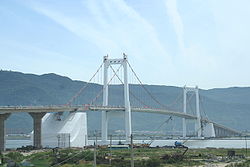 Thuận Phước Bridge
 Hàn River Bridge
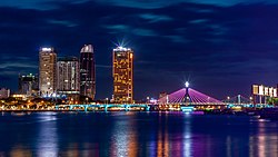 Han River Bridge at night, looking northwest
 Han River, looking north from the Dragon Bridge
 Hàn River, looking north near left bank city center.
 Aerial view: Han River, Dragon Bridge, left bank, looking northwest


| Hàn River Tourane River, Danang River | |
|---|---|
 The Hàn River near Trần Thị Lý Bridge. | |
  | |
| Native name | sông Hàn (Vietnamese) |
| Location | |
| Country | Vietnam |
| Region | South Central Coast |
| Cities | Da Nang |
| Physical characteristics | |
| Source | Confluence of Cẩm Lệ and Đò Toản |
| • location | boundary between Hòa Xuân, Ngũ Hành Sơn, and Hòa Cường |
| • coordinates | 16°01′45″N 108°13′52″E |
| Mouth | Da Nang Bay (South China Sea) |
• location | boundary between Hải Châu, Sơn Trà |
• coordinates | 16°05′49″N 108°13′13″E |
| Length | 9.8 km [1] |
| Width | |
| • average | 900 - 1200 m |
| Depth | |
| • average | 4 - 5 m |
| Basin features | |
| Bridges | Tiên Sơn Bridge, Trần Thị Lý Bridge, Nguyễn Văn Trỗi Bridge, Dragon Bridge, Hàn River Bridge, Thuận Phước Bridge |