Valtournenche
Comune in Aosta Valley, Italy
From Wikipedia, the free encyclopedia
Valtournenche (French: [valtuʁnɑ̃ʃ] ⓘ; Valdôtain: Vótornéntse) is a town and comune in the Aosta Valley region of north-western Italy, 1,500 m (4,900 ft) above the sea level. It is named after and covers the upper side of the Valtournenche, a valley on the left side of the Dora Baltea, from Châtillon to the Matterhorn. Valtournenche municipality includes Breuil-Cervinia, whose ski resort is linked to Zermatt, Switzerland.[4]

CountryItaly
FrazioniLes Arsines, Avouil, La Barmasse, Les Battendières, Le Bioley, La Brengaz, Le Breuil, Chaloz, Champcartanaz, Champlève, Les Châtelards, Cheneil, Cheperon, Les Clous, Crépin, Le Crêt, Crétaz, Le Crêt-des-Perrères, Le Crou-Dessous, Le Crou-Dessus, Duerche, L'Évette, Facebellaz, La Fontanaz, Le Glair, La Glarénaz, Le Gouffre-des-Busserailles, Le Lac-Bleu, Les Laviels, Losanche, Le Loz, Maën, La Maisonnasse, La Montat, Le Mont-Mené, Le Mont-Perron, Le Moulin, La Murenche, Pâquier (chef-lieu), Pecou, Les Perrères, Pessey, Les Ponteils, Les Prés, Promindot, Les Saix, La Servaz, Singlin, Tourtourouse, Ussin, Valmartin, La Venal[1]
Elevation1,528 m (5,013 ft)
DemonymValtournains
Valtournenche
Vótornéntse (Valdôtain) | |
|---|---|
| Comune di Valtournenche Commune de Valtournenche | |
 | |
 Coat of arms | |
 Valtournenche Location of Valtournenche in Italy  Valtournenche Valtournenche (Aosta Valley) | |
| Coordinates: 45°53′N 07°37′E | |
| Country | Italy |
| Region | Aosta Valley |
| Province | none |
| Frazioni | Les Arsines, Avouil, La Barmasse, Les Battendières, Le Bioley, La Brengaz, Le Breuil, Chaloz, Champcartanaz, Champlève, Les Châtelards, Cheneil, Cheperon, Les Clous, Crépin, Le Crêt, Crétaz, Le Crêt-des-Perrères, Le Crou-Dessous, Le Crou-Dessus, Duerche, L'Évette, Facebellaz, La Fontanaz, Le Glair, La Glarénaz, Le Gouffre-des-Busserailles, Le Lac-Bleu, Les Laviels, Losanche, Le Loz, Maën, La Maisonnasse, La Montat, Le Mont-Mené, Le Mont-Perron, Le Moulin, La Murenche, Pâquier (chef-lieu), Pecou, Les Perrères, Pessey, Les Ponteils, Les Prés, Promindot, Les Saix, La Servaz, Singlin, Tourtourouse, Ussin, Valmartin, La Venal[1] |
| Area | |
• Total | 115 km2 (44 sq mi) |
| Elevation | 1,528 m (5,013 ft) |
| Population (31 December 2022)[3] | |
• Total | 2,178 |
| • Density | 18.9/km2 (49.1/sq mi) |
| Demonym | Valtournains |
| Time zone | UTC+1 (CET) |
| • Summer (DST) | UTC+2 (CEST) |
| Postal code | 11028 |
| Dialing code | 0166 |
| Website | http://www.comune.valtournenche.ao.it |
History
Notable people
- Jean-Antoine Carrel (1829–1890), mountain climber
- Jean-Joseph Maquignaz (1829–1890), mountain climber
- Georges Carrel (1800–1870), canon, mountain climber and botanist
- Luigi Carrel (1901–1983), mountain climber
- Piero Maquignaz, skier and mountain climber
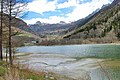 The Maën lake.
 Maën lake seen from Pâquier.

