Wikipedia:WikiProject Seamounts/Images
From Wikipedia, the free encyclopedia
Wikimedia Commons has media related to Submarine volcanoes.
Wikimedia Commons has media related to Seamounts.
Wikimedia Commons has media related to Bowie Seamount.
Generic
 Stylized SVG logo, by Resident Mario
 Another version of the genric Seamount logo, also by Resident Mario
 Lava explodes as ocean water covers the lava tube
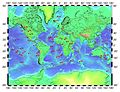 Hotspot map
 Useful Plate Tectonics reference image


Maps
 Trail of seamounts created by the Hawaii hotspot, known as the Hawaiian-Emperor seamount chain.
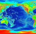 Uncropped version.
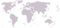 Genral map showing location of all major seamounts of the world.
 Map of submarine volcanoes on the coast of British Columbia.
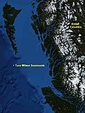
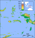 Indonesia underwater volcano locator, used with next image to indicate locations:
 See previous; useful location marker via z-index positioning.

 Protector Shoal locator map
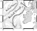
 Juan de Fuca Ridge map showing the location of Axial Seamount
 Juan de Fuca Ridge map showing the location of Axial Seamount
 Cordell Bank National Marine Sanctuary map, with seamounts attached
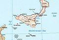 X marks the spot of Ferdinandea, a Medditeranian seamount


Seamounts
 3-D Pierce Seamount visualization
 3-D Hodgkins Seamount visualization.
 Aster satellite image of the new volcanic island called "Home Reef"
 Kick 'em Jenny Seamount; see details on its page.
 Underwater topography of Cordell Bank
 Orca Seamount in the Bransfield Strait, Antarctic Peninsula.
- Great Meteor Seamount, Little Meteor Seamount, Closs Bank mapping.
 Uploaded by Resident Mario in preparation for Orca Seamount article
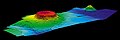


GAs/FAs
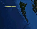 Map of Bowie Seamount
 3-D Bowie Seamount Depiction
 Another 3-D Bowie Seamount, with Hodgkins Seamount in the background.
 Bowie Seamount outline, showing its Marine Protected Area status.
 Eastern Flank
 Top view
 Another view
- X marks the spot of Ferdinandea, a Medditeranian seamount
- Artistic rendering of the 1831 Ferdinandea eruptionArtistic rendering of the 1831 Ferdinandea eruption
 French geologist's entry for Ferdinandea
 Yellow iron oxide covered lava rock on the flank of Loihi
 Bathemetric mapping of Loihi
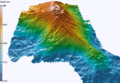 3D Rendering of Loihi
- Great Meteor Seamount, Little Meteor Seamount, Closs Bank mapping.

 Another view, with tracklines from the 2002 expedition.


Biota/Other
 Biota on the NE seamount chain
 Pillow Lava, a type of lava originating from Seamounts.
 Benthic octopus and clam on the Davidson Seamount at 1461 meters.
- Yellow rust covering lava rocks on Loihi Seamount


