Torrejoncillo del Rey
Gemeinde in Spanien
From Wikipedia, the free encyclopedia
Torrejoncillo del Rey ist eine Gemeinde (Municipio) und ein Dorf mit 341 Einwohnern (Stand: 2025) in der Provinz Cuenca in der Autonomen Region Kastilien-La Mancha. Neben dem Hauptort Torrejoncillo del Rey gehören die Ortschaften Horcajada de la Torre, Naharros, Villar del Águila, Villar del Horno und Villarejo-Sobrehuerta zur Gemeinde.

| Gemeinde Torrejoncillo del Rey | |||
|---|---|---|---|
| |||
| Wappen | Karte von Spanien | ||
 |
| ||
| Basisdaten | |||
| Land: |  Spanien Spanien | ||
| Autonome Gemeinschaft: |  Kastilien-La Mancha Kastilien-La Mancha | ||
| Provinz: | Cuenca | ||
| Comarca: | La Mancha de Cuenca | ||
| Gerichtsbezirk: | Cuenca | ||
| Koordinaten: | 40° 0′ N, 2° 34′ W | ||
| Höhe: | 910 msnm[1] | ||
| Fläche: | 33,43 km²[2] | ||
| Einwohner: | 341 (Stand: 2025)[3] | ||
| Bevölkerungsdichte: | 10 Einw./km² | ||
| Postleitzahl(en): | 16161 | ||
| Gemeindenummer (INE): | 16266 | ||
| Verwaltung | |||
| Bürgermeister: | Piedad Balsalobre Saiz (PSOE) | ||
| Website: | Torrejoncillo del Rey | ||
| Lage des Ortes | |||
Karte anzeigen  | |||


Lage
Torrejoncillo del Rey liegt etwa 40 Kilometer westlich von Cuenca in einer Höhe von ca. 930 m am Cigüela. Durch die Gemeinde führt die Autovía A-40.
Bevölkerungsentwicklung
Sehenswürdigkeiten
- Dominikuskirche (Iglesia de Santo Domingo de Silos) in Villar del Águila
- Einsamkeitskapelle (Ermita de Solitud)
- Peter-und-Paul-Kirche in Villarejo-Sobrehuerta
- Ruine der Bartholomäuskapelle in Villarejo-Sobrehuerta
- Jakobuskirche in Naharros
- Rathaus
 Dominikuskirche
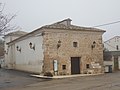 Einsamkeitskapelle
 Peter-und-Paul-Kirche
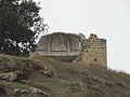 Ruine der Bartholomäuskapelle
 Jakobuskirche
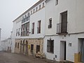 Rathaus


Weblinks
Commons: Torrejoncillo del Rey – Sammlung von Bildern, Videos und Audiodateien
