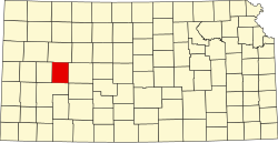
Alamota Township, Lane County, Kansas
From Wikipedia, the free encyclopedia
Alamota Township | |
|---|---|
 Location in Lane County | |
| Coordinates: 38°24′28″N 100°19′10″W / 38.40778°N 100.31944°W | |
| Country | United States |
| State | Kansas |
| County | Lane |
| Area | |
• Total | 159.826[1] sq mi (413.95 km2) |
| • Land | 159.826 sq mi (413.95 km2) |
| • Water | 0 sq mi (0 km2) 0% |
| Population (2020) | |
• Total | 80 |
| • Density | 0.50/sq mi (0.19/km2) |
| Time zone | UTC-6 (CST) |
| • Summer (DST) | UTC-5 (CDT) |
| Area code | 620 |
Alamota Township is a township in Lane County, Kansas, United States. As of the 2020 census, its population was 80.[2]