Altenkunstadt
From Wikipedia, the free encyclopedia
Altenkunstadt | |
|---|---|
 Church of the Nativity of the Virgin Mary and the rectory | |
_COA.svg) Coat of arms | |
Location of Altenkunstadt
within Lichtenfels district 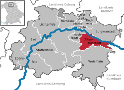 | |
 Location of Altenkunstadt | |
 Altenkunstadt  Altenkunstadt | |
| Coordinates: 50°07′N 11°15′E / 50.117°N 11.250°E | |
| Country | Germany |
| State | Bavaria |
| Admin. region | Oberfranken |
| District | Lichtenfels |
| Subdivisions | 12 Ortsteile |
| Government | |
| • Mayor (2020–26) | Robert Hümmer[1] (CSU) |
| Area | |
• Total | 32.91 km2 (12.71 sq mi) |
| Elevation | 292 m (958 ft) |
| Population (2024-12-31)[2] | |
• Total | 5,502 |
| • Density | 167.2/km2 (433.0/sq mi) |
| Time zone | UTC+01:00 (CET) |
| • Summer (DST) | UTC+02:00 (CEST) |
| Postal codes | 96264 |
| Dialling codes | 09572 |
| Vehicle registration | LIF/STE |
| Website | www.altenkunstadt.de |
Altenkunstadt (German pronunciation: [altn̩ˈkʊnʃtat]) is a municipality in the district of Lichtenfels in Bavaria, Germany. It lies on the left or south bank of the river Main across the valley from Burgkunstadt which sits on the hillside to the north.
