Amstelhoek
Village in Utrecht, Netherlands
From Wikipedia, the free encyclopedia
Amstelhoek is a village in the Dutch province of Utrecht. It is in the municipality of De Ronde Venen, about 3 km (1.9 mi) northwest of Mijdrecht. Amstelhoek lies on the river Amstel, directly across from Uithoorn.

Amstelhoek
Mennonietenbuurt | |
|---|---|
Village | |
Amstelhoek in 2015 | |
  Amstelhoek Location in the Netherlands  Amstelhoek Amstelhoek (Netherlands) | |
| Coordinates: 52°13′52″N 4°50′6″E | |
| Country | Netherlands |
| Province | Utrecht |
| Municipality | De Ronde Venen |
| Area | |
• Total | 0.95 km2 (0.37 sq mi) |
| Elevation | −1.0 m (−3.3 ft) |
| Population (2021)[1] | |
• Total | 985 |
| • Density | 1,000/km2 (2,700/sq mi) |
| Time zone | UTC+1 (CET) |
| • Summer (DST) | UTC+2 (CEST) |
| Postal code | 1427[1] |
| Dialing code | 0297 |
It was first mentioned in 1936 as Amstelhoek, and means "corner of the Amstel river". It was named after the fortress.[3] The village developed around a bridge built in 1636, and used to be named Mennonietenbuurt,[4] meaning Mennonite corner, because a Mennonite church was built in the hamlet.[5] The Mennonites left around 1800, and sold the land and church to the Protestants in 1804. The village was home to 187 people in 1840.[6] Between 1885 and 1895, two big forts were built near the village as part of the Stelling van Amsterdam. One of the forts was named Fort bij Amstelhoek.[4]
Gallery
 Church of Amstelhoek
 River view
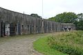 Barracks of the fort

.jpg)


-Flag.svg)