Andelaroche
From Wikipedia, the free encyclopedia
Andelaroche | |
|---|---|
 The road into Andelaroche | |
 Location of Andelaroche | |
 Andelaroche  Andelaroche | |
| Coordinates: 46°15′22″N 3°45′00″E / 46.2561°N 3.75°E | |
| Country | France |
| Region | Auvergne-Rhône-Alpes |
| Department | Allier |
| Arrondissement | Vichy |
| Canton | Lapalisse |
| Intercommunality | Pays de Lapalisse |
| Government | |
| • Mayor (2026–2032) | Henri Cabaud[1] |
Area 1 | 20.28 km2 (7.83 sq mi) |
| Population (2023)[2] | 214 |
| • Density | 10.6/km2 (27.3/sq mi) |
| Demonym | Andelarochois |
| Time zone | UTC+01:00 (CET) |
| • Summer (DST) | UTC+02:00 (CEST) |
| INSEE/Postal code | 03004 /03120 |
| Elevation | 338–534 m (1,109–1,752 ft) (avg. 428 m or 1,404 ft) |
| 1 French Land Register data, which excludes lakes, ponds, glaciers > 1 km2 (0.386 sq mi or 247 acres) and river estuaries. | |
Andelaroche (French pronunciation: [ɑ̃dlaʁɔʃ]) is a commune in the Allier department in the Auvergne-Rhône-Alpes region of central France.
The inhabitants of the commune are known as Andelarochois or Andelarochoises.[3][4]
Neighbouring communes and villages
Andelaroche is located some 10 kilometres (6.2 mi) east of Lapalisse and some 25 kilometres (16 mi) west of Marcigny. The D990/D994 road passes through the west of the commune from south-west to north-east. Access to the village is by the minor D424 road from Barrais-Bussolles in the north through the commune and the village then continuing south-east to Saint-Martin-d'Estreaux. The minor D470 road also goes from the village south-west to Droiturier. The commune is mostly farmland with a large forest in the south-east, the Bois de Saint Pierre in the centre, and a few isolated patches of forest towards the north.[5]
The Andan river forms the south-western border of the commune, the Ruisseau de Maupes forms the north-western border, and the Ruisseau de l'Etang Civette forms part of the eastern border. Numerous other streams criss-cross the commune with many small lakes.[5]
Places adjacent to Andelaroche | |
|---|---|
Administration

Population
| Year | Pop. | ±% p.a. |
|---|---|---|
| 1968 | 371 | — |
| 1975 | 357 | −0.55% |
| 1982 | 300 | −2.45% |
| 1990 | 288 | −0.51% |
| 1999 | 267 | −0.84% |
| 2007 | 285 | +0.82% |
| 2012 | 268 | −1.22% |
| 2017 | 258 | −0.76% |
| 2023 | 214 | −3.07% |
| Source: INSEE[9] | ||

Sites and monuments

- There is a church of Romanesque origin but much altered in the 19th century. It is now a composite structure that has lost its original appearance.
Andelaroche Picture Gallery
 A street in Andelaroche
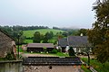 Andelaroche Landscape
 A Wayside Cross in Andelaroche


