Arnay-sous-Vitteaux
From Wikipedia, the free encyclopedia
Arnay-sous-Vitteaux | |
|---|---|
 The road into Arnay-sous-Vitteaux | |
 Location of Arnay-sous-Vitteaux | |
 Arnay-sous-Vitteaux  Arnay-sous-Vitteaux | |
| Coordinates: 47°26′49″N 4°29′54″E / 47.4469°N 4.4983°E | |
| Country | France |
| Region | Bourgogne-Franche-Comté |
| Department | Côte-d'Or |
| Arrondissement | Montbard |
| Canton | Semur-en-Auxois |
| Intercommunality | CC Terres Auxois |
| Government | |
| • Mayor (2020–2026) | Jean François Lallemant[1] |
Area 1 | 12.14 km2 (4.69 sq mi) |
| Population (2023)[2] | 113 |
| • Density | 9.31/km2 (24.1/sq mi) |
| Time zone | UTC+01:00 (CET) |
| • Summer (DST) | UTC+02:00 (CEST) |
| INSEE/Postal code | 21024 /21350 |
| Elevation | 277–482 m (909–1,581 ft) (avg. 235 m or 771 ft) |
| 1 French Land Register data, which excludes lakes, ponds, glaciers > 1 km2 (0.386 sq mi or 247 acres) and river estuaries. | |
Arnay-sous-Vitteaux (French pronunciation: [aʁnɛ su vito], literally Arnay under Vitteaux) is a commune in the Côte-d'Or department in the Bourgogne-Franche-Comté region of eastern France.
Neighbouring communes and villages
Arnay-sous-Vitteaux is located some 50 km north-west of Dijon and 35 km south-east of Montbard. Access to the commune is by the D905 road from Vitteaux in the south passing through the east of the commune and continuing north to Venarey-les-Laumes. Access to the village is by the D1178 from Marigny-le-Cahouët in the north-west passing through the village then north-east to join the D905. There are forests in the west, centre, and east of the commune with the rest being farmland.[3]
The Brenne river passes through the commune from south to north parallel to and west of the D905. The Ruisseau de Chassaigne rises in the south of the commune and flows north through the village to join the Brenne east of the village.[3]
Places adjacent to Arnay-sous-Vitteaux | |
|---|---|
Administration

List of Successive Mayors[4]
| From | To | Name |
|---|---|---|
| 2001 | 2014 | André Gras |
| 2014 | 2026 | Jean François Lallemant |
Demography
The inhabitants of the commune are known as Arnétois or Arnétoises in French.[5]
Historical population | ||||||||||||||||||||||||||||||||||||||||||||||||||||||||||
|
| |||||||||||||||||||||||||||||||||||||||||||||||||||||||||
| Source: EHESS[6] and INSEE[7] | ||||||||||||||||||||||||||||||||||||||||||||||||||||||||||


Sites and monuments
- The Fortified house of Arnay.[8]
- The Chapel of Saint Abdon.
- The Parish Church of Saint Alban contains several items that are registered as historical objects:
Gallery of Historical Items
 The Chapel of Abdon in 2012 before restoration
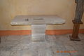 The original stone altar in the Chapel of Saint Abdon
 A Fragment of a Calvary dated 1502 in the Chapel of Abdon
 An ancient Sarcophagus in the Chapel of Saint Abdon discovered nearby
 The Church of Saint Alban
 The Stained glass window: Virgin and child with donors
 The Monumental Painting: a Bishop and a Consecrational Cross


