Ashwood, Texas
From Wikipedia, the free encyclopedia
Ashwood, Texas | |
|---|---|
 Ashwood sign on FM 1728 | |
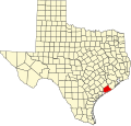
 Ashwood Location within the state of Texas  Ashwood Ashwood (the United States) | |
| Coordinates: 29°06′15″N 95°52′17″W / 29.10417°N 95.87139°W | |
| Country | United States |
| State | Texas |
| County | Matagorda |
| Elevation | 56 ft (17 m) |
| Time zone | UTC-6 (Central (CST)) |
| • Summer (DST) | UTC-5 (CDT) |
| ZIP code | 77482 |
| Area code | 979 |
| GNIS feature ID | 1379368[1] |
Ashwood is a small unincorporated community in Matagorda County, Texas, United States.[1] It is located at the intersection of FM 1728 and County Road 112. The community was established when a railroad was built through the area around 1900. It had a post office between 1910 and 1952 when it closed.