Auboncourt-Vauzelles
From Wikipedia, the free encyclopedia
Auboncourt-Vauzelles | |
|---|---|
_vue_du_village_d'Auboncourt.JPG) View of the Village | |
 Location of Auboncourt-Vauzelles | |
 Auboncourt-Vauzelles  Auboncourt-Vauzelles | |
| Coordinates: 49°33′10″N 4°29′38″E / 49.5528°N 4.4939°E | |
| Country | France |
| Region | Grand Est |
| Department | Ardennes |
| Arrondissement | Rethel |
| Canton | Signy-l'Abbaye |
| Intercommunality | CC Crêtes Préardennaises |
| Government | |
| • Mayor (2020–2026) | Benoît Carier[1] |
Area 1 | 5.4 km2 (2.1 sq mi) |
| Population (2023)[2] | 95 |
| • Density | 18/km2 (46/sq mi) |
| Time zone | UTC+01:00 (CET) |
| • Summer (DST) | UTC+02:00 (CEST) |
| INSEE/Postal code | 08027 /08270 |
| Elevation | 86–127 m (282–417 ft) (avg. 98 m or 322 ft) |
| 1 French Land Register data, which excludes lakes, ponds, glaciers > 1 km2 (0.386 sq mi or 247 acres) and river estuaries. | |
Auboncourt-Vauzelles (French pronunciation: [obɔ̃kuʁ vozɛl]) is a commune in the Ardennes department in the Grand Est region of north-eastern France.
Neighbouring communes and villages
Auboncourt-Vauzelles is located some 38 km south-west of Charleville-Mézières and 16 km north-east of Rethel. The A34 autoroute passes through the north-west of the commune but the nearest exit is Exit 14 some 6 km north of the commune. Access to the commune is by the D 951 road from Novy-Chevrières in the south-west which passes through the north-west of the commune and the hamlet of Vauzelles as it goes north to join the A34 autoroute at Exit 14. The D 14 road comes from Corny-Machéroménil in the north-west which passes through Vauzelles and the centre of the commune before continuing south to Faux. Access to the village is by small roads that run off the D 14 - the Chemin d'Auboncourt and the Chemin de la Fontaine. The commune is entirely farmland except for the fringe of the Bois d'Auboncourt forest in the north-east.[3]
The Ruisseau de Saulces flows through the east of the commune and the village from north to south-east and continues to join the Aisne south of Amagne.[3]
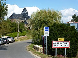 Entrance to the village
 The lavoir (public laundry)
 The church
 The war memorial
_city_limit_sign.JPG)
_Lavoir.JPG)
_église_(2).JPG)
_monument_aux_morts.JPG)
Places adjacent to Auboncourt-Vauzelles[3] | ||||||||||||||||
|---|---|---|---|---|---|---|---|---|---|---|---|---|---|---|---|---|
| ||||||||||||||||
Administration
_mairie.JPG)
| From | To | Name |
|---|---|---|
| 1995 | 2008 | Michel Hot |
| 2008 | 2012 | Armelle Malherbe |
| 2012 | current | Benoît Carier |
Demography
The population data given in the table and graph below for 1821 and earlier refer to the former commune of Auboncourt. The number for 1793 includes the commune of Monclin.
Historical population | ||||||||||||||||||||||||||||||||||||||||||||||||||||||||||||||||||||||
|
| |||||||||||||||||||||||||||||||||||||||||||||||||||||||||||||||||||||
| Source: EHESS[5] and INSEE[6] | ||||||||||||||||||||||||||||||||||||||||||||||||||||||||||||||||||||||