Aubry-le-Panthou
Commune in Normandy, France
From Wikipedia, the free encyclopedia
Aubry-le-Panthou (French pronunciation: [obʁi lə pɑ̃tu] ⓘ) is a commune in the Orne department in north-western France.

Aubry-le-Panthou | |
|---|---|
The church in Aubry-le-Panthou | |
 Location of Aubry-le-Panthou | |
 Aubry-le-Panthou  Aubry-le-Panthou | |
| Coordinates: 48°51′05″N 0°14′01″E | |
| Country | France |
| Region | Normandy |
| Department | Orne |
| Arrondissement | Mortagne-au-Perche |
| Canton | Vimoutiers |
| Intercommunality | CC Vallées Auge Merlerault |
| Government | |
| • Mayor (2020–2026) | Jean-Claude Laigre[1] |
Area 1 | 6.85 km2 (2.64 sq mi) |
| Population (2023)[2] | 133 |
| • Density | 19.4/km2 (50.3/sq mi) |
| Time zone | UTC+01:00 (CET) |
| • Summer (DST) | UTC+02:00 (CEST) |
| INSEE/Postal code | 61010 /61120 |
| Elevation | 133–256 m (436–840 ft) (avg. 172 m or 564 ft) |
| 1 French Land Register data, which excludes lakes, ponds, glaciers > 1 km2 (0.386 sq mi or 247 acres) and river estuaries. | |
Geography
The commune along with another 11 communes is part of a 1,400 hectare, Natura 2000 conservation area, called the Haute Vallée de la Touques et affluents.[3]
The River Vie runs through the commune in addition to two streams, the Val Roger & the Mont-Ormel.
Population
| Year | Pop. | ±% p.a. |
|---|---|---|
| 1968 | 207 | — |
| 1975 | 121 | −7.38% |
| 1982 | 89 | −4.29% |
| 1990 | 106 | +2.21% |
| 1999 | 93 | −1.44% |
| 2009 | 99 | +0.63% |
| 2014 | 108 | +1.76% |
| 2020 | 123 | +2.19% |
| Source: INSEE[5] | ||
Points of Interest
- Coteau des Champs-Genêts is a 29 hectare Sensitive Natural Space of Orne.[6] The reserve features the following fauna and flora Camargue horses, Boloria dia, Adonis blue, Vincetoxicum hirundinaria, Dactylorhiza viridis and Gentiana cruciata.[7]
- Vajradhara-Ling is a Buddhist centre based in the commune since 1982.[8]
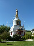 Vajradhara-Ling
 Aubry-le-Panthou Church
 Castle of Osmont


