Awat County
County in Xinjiang, China
From Wikipedia, the free encyclopedia
Awat County[4][5][6] (Uyghur: ئاۋات ناھىيىسى) is a county in Aksu Prefecture, Xinjiang Uyghur Autonomous Region, China. Awat County is located on the southern foot of the Tian Shan mountain range and on the northern edge of the Taklamakan Desert.[2][7]
.png)
Awat County
Awati | |
|---|---|
Location of the county in Aksu Prefecture (yellow) and Xinjiang | |
 Awat Location of the seat in Xinjiang  Awat Awat (China) | |
| Country | China |
| Autonomous region | Xinjiang |
| Prefecture | Aksu |
| County seat | Awat Town |
| Township-level divisions | 5 towns, 3 townships |
| Area | |
• Total | 13,017.89 km2 (5,026.24 sq mi) |
| Population (2020)[1] | |
• Total | 242,481 |
| • Density | 18.6268/km2 (48.2431/sq mi) |
| Ethnic groups | |
| • Major ethnic groups | Uyghur, Han Chinese[2][3] |
| Time zone | UTC+8 (China Standard[a]) |
| Postal code | 843200 |
| Website | www |
| Awat County | |||||||||||
|---|---|---|---|---|---|---|---|---|---|---|---|
| Uyghur name | |||||||||||
| Uyghur | ئاۋات ناھىيىسى | ||||||||||
| |||||||||||
| Chinese name | |||||||||||
| Simplified Chinese | 阿瓦提县 | ||||||||||
| Traditional Chinese | 阿瓦提縣 | ||||||||||
| |||||||||||
History
The term "Awat" translates from Uyghur to signify "prosperity".[8] The region surrounding Awat County was formerly known as "Dolang," the ancestral home of the "Dolang people," an old Uyghur tribe. Subsequently, a significant influx of peasants settled in the region, resulting in a population surge, an expansion of cultivated land, and a daily transformation of the landscape, prompting the renaming to Awat.[9]
During the Han dynasty, it was part of Gumo. During the Tang dynasty, it was part of Gumo Prefecture.[10][11] In 1883, Aksu Dao was established, with Awat falling under its control. In 1913, the area was part of the three, four, and five districts of Aksu County; in 1922, Awat County was established. Awat County was established in 1930,[12] initially part of Aksu Dao, and subsequently became part of the Aksu District Administrator's Office in 1933. In 1943, it pertains to the Aksu Administrative Inspector General's Office.[13] The People's Government of the County of Awat was officially created in 1950.[14] Subsequently, it has been governed by the Aksu Commissioner's Office and the Aksu Regional Administrative Office.[15]
On January 23, 2013, the People's Government of Xinjiang Uygur Autonomous Region (Xin Zheng Xin [2013] No. 17) sanctioned the transfer of 474.208 square kilometers of Awat County to Aral City's administration.[16]
Administrative divisions
Awat County is made up of seven towns, two townships and one other area:[2][12][17]
| Name | Simplified Chinese | Hanyu Pinyin | Uyghur (UEY) | Uyghur Latin (ULY) | Administrative division code | Notes | |
|---|---|---|---|---|---|---|---|
| Towns | |||||||
| Awat Town | 阿瓦提镇 | Āwǎtí Zhèn | ئاۋات بازىرى | Awat baziri | 652928100 | ||
| Ghoruchol Town[18] | 乌鲁却勒镇 | Wūlǔquèlè Zhèn | غورۇچۆل بازىرى[19] | ghoruchöl baziri | 652928101 | formerly Ghoruchol Township (乌鲁却勒乡) | |
| Besheriq Town | 拜什艾日克镇 | Bàishí'àirìkè Zhèn | بەشئېرىق بازىرى | besh'ëriq baziri | 652928102 | formerly Besheriq Township (拜什艾日克乡) | |
| Tamtoghraq Town | 塔木托格拉克镇 | Tǎmùtuōgélākè Zhèn | تامتوغراق بازىرى | tamtoghraq baziri | 652928103 | formerly Tamtoghraq Township (تامتوغراق يېزىسى / 塔木托格拉克乡) | |
| Yengierik Town[20][21] | 英艾日克镇 | Yīng'àirìkè Zhèn | يېڭىئېرىق بازىرى | yëngi'ëriq baziri | 652928104 | formerly Yengierik Township (يېڭىئېرىق يېزىسى / 英艾日克乡) | |
| Aybagh Town | 阿依巴格镇 | Āyībāgé Zhèn | ئايباغ بازىرى | Aybagh baziri | 652928105 | formerly Aybagh Township (ئايباغ يېزىسى / 阿依巴格乡) | |
| Sanhe Town | 三河镇 | Sānhé Zhèn | سەنخې بازىرى | senxë baziri | 652928106 | Established on 30 December 2020 | |
| Townships | |||||||
| Dolan Township[22] | 多浪乡 | Duōlàng Xiāng | دولان يېزىسى | dolan yëzisi | 652928203 | ||
| Baytoghraq Township | 巴格托格拉克乡 | Bāgétuōgélākè Xiāng | بايتوغراق يېزىسى | baytoghraq yëzisi | 652928204 | ||
Demographics
| Year | Pop. | ±% p.a. |
|---|---|---|
| 2000 | 209,654 | — |
| 2010 | 237,562 | +1.26% |
| [12] | ||
As of 1999, 81.59% of the population of Awat (Awati) County was Uyghur and 17.74% of the population was Han Chinese.[23]
According to the 2010 Sixth Population Census, the total resident population of Awati County was 237,562. As of 2015, 217,722 of the 262,842 residents of the county were Uyghur, 42,960 were Han Chinese, 2,160 were from other ethnic groups.[24]
Climate
| Climate data for Awat, elevation 1,044 m (3,425 ft), (1991–2020 normals, extremes 1981–2010) | |||||||||||||
|---|---|---|---|---|---|---|---|---|---|---|---|---|---|
| Month | Jan | Feb | Mar | Apr | May | Jun | Jul | Aug | Sep | Oct | Nov | Dec | Year |
| Record high °C (°F) | 8.2 (46.8) |
14.6 (58.3) |
27.8 (82.0) |
35.6 (96.1) |
36.2 (97.2) |
38.3 (100.9) |
39.0 (102.2) |
39.2 (102.6) |
34.1 (93.4) |
29.8 (85.6) |
22.1 (71.8) |
10.9 (51.6) |
39.2 (102.6) |
| Mean daily maximum °C (°F) | −0.5 (31.1) |
5.9 (42.6) |
15.0 (59.0) |
23.5 (74.3) |
28.0 (82.4) |
31.0 (87.8) |
32.0 (89.6) |
30.8 (87.4) |
27.0 (80.6) |
20.4 (68.7) |
10.5 (50.9) |
1.3 (34.3) |
18.7 (65.7) |
| Daily mean °C (°F) | −7.4 (18.7) |
−1.2 (29.8) |
7.7 (45.9) |
15.8 (60.4) |
20.3 (68.5) |
23.2 (73.8) |
24.3 (75.7) |
23.1 (73.6) |
18.5 (65.3) |
10.7 (51.3) |
2.0 (35.6) |
−5.1 (22.8) |
11.0 (51.8) |
| Mean daily minimum °C (°F) | −13.1 (8.4) |
−7.3 (18.9) |
1.1 (34.0) |
8.5 (47.3) |
13.1 (55.6) |
16.2 (61.2) |
17.6 (63.7) |
16.6 (61.9) |
11.5 (52.7) |
3.4 (38.1) |
−3.8 (25.2) |
−9.7 (14.5) |
4.5 (40.1) |
| Record low °C (°F) | −26.0 (−14.8) |
−25.0 (−13.0) |
−12.1 (10.2) |
−3.0 (26.6) |
2.2 (36.0) |
7.4 (45.3) |
8.2 (46.8) |
8.0 (46.4) |
3.3 (37.9) |
−5.5 (22.1) |
−14.1 (6.6) |
−21.9 (−7.4) |
−26.0 (−14.8) |
| Average precipitation mm (inches) | 1.0 (0.04) |
1.7 (0.07) |
1.6 (0.06) |
2.5 (0.10) |
9.1 (0.36) |
16.6 (0.65) |
14.8 (0.58) |
12.6 (0.50) |
9.3 (0.37) |
2.5 (0.10) |
1.0 (0.04) |
1.1 (0.04) |
73.8 (2.91) |
| Average precipitation days (≥ 0.1 mm) | 1.7 | 1.1 | 0.7 | 1.3 | 3.2 | 6.2 | 6.7 | 5.7 | 3.3 | 1.3 | 0.7 | 1.5 | 33.4 |
| Average snowy days | 5.0 | 2.4 | 0.3 | 0.1 | 0 | 0 | 0 | 0 | 0 | 0.1 | 0.7 | 4.9 | 13.5 |
| Average relative humidity (%) | 69 | 60 | 47 | 39 | 42 | 50 | 56 | 59 | 62 | 63 | 66 | 74 | 57 |
| Mean monthly sunshine hours | 182.9 | 184.5 | 206.5 | 230.1 | 271.1 | 297.4 | 309.1 | 285.2 | 261.6 | 258.2 | 206.0 | 168.9 | 2,861.5 |
| Percentage possible sunshine | 61 | 60 | 55 | 57 | 60 | 66 | 68 | 68 | 71 | 77 | 71 | 59 | 64 |
| Source: China Meteorological Administration[25][26] | |||||||||||||
Economy
A developed irrigation system is in place and agricultural products include wheat, rice, corn and cotton. Sheep are the primary livestock in the county. Industries include coal, construction, food processing, leathermaking and carpetmaking.[27]
One quarter of the cotton production in Aksu prefecture comes from the county.[28]
Historical maps
Historical English-language maps including Awat:
 Map including Awat (1917)
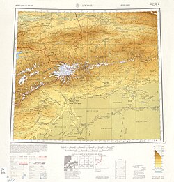 Map including Awat (labeled as A-wa-t'i (Abad)) and surrounding region from the International Map of the World (AMS, 1950)[b]
 Map including Awat (DMA, 1981)
_p61_PLATE19._SINKIANG_(14597194848).jpg)
_-_panoramio.jpg)


Notes
- Locals in Xinjiang frequently observe UTC+6 (Xinjiang Time), 2 hours behind Beijing.
- From map: "THE DELINEATION OF INTERNATIONAL BOUNDARIES ON THIS MAP MUST NOT BE CONSIDERED AUTHORITATIVE"
- From map: "The representation of international boundaries is not necessarily authoritative."