Bad Kohlgrub
From Wikipedia, the free encyclopedia
Bad Kohlgrub | |
|---|---|
 Bad Kohlgrub from the northeast | |
 Coat of arms | |
Location of Bad Kohlgrub within Garmisch-Partenkirchen district 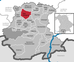 | |
 Bad Kohlgrub  Bad Kohlgrub | |
| Coordinates: 47°40′N 11°03′E / 47.667°N 11.050°E | |
| Country | Germany |
| State | Bavaria |
| Admin. region | Oberbayern |
| District | Garmisch-Partenkirchen |
| Government | |
| • Mayor (2018–24) | Franz Degele[1] (FW) |
| Area | |
• Total | 32.66 km2 (12.61 sq mi) |
| Elevation | 828 m (2,717 ft) |
| Population (2024-12-31)[2] | |
• Total | 2,875 |
| • Density | 88/km2 (230/sq mi) |
| Time zone | UTC+01:00 (CET) |
| • Summer (DST) | UTC+02:00 (CEST) |
| Postal codes | 82433 |
| Dialling codes | 08845 |
| Vehicle registration | GAP |
| Website | www.bad-kohlgrub.de |
Bad Kohlgrub is a German municipality in the district of Garmisch-Partenkirchen, in Bavaria. It lies 12 kilometres (7.5 mi) west of Murnau am Staffelsee and 8 kilometres (5.0 mi) north of Oberammergau, and is connected to both by the Ammergau Railway.
Skiing facilities include 4 ski lifts, 4 pistes and 30 kilometres (19 mi) of cross-country skiing trails.[3] A chairlift (opened 1954[4]) south of the town leads up to the Hörnlehütte below the summit of the Hörnle mountain (1,547 metres/5,075 ft).[5]
The municipality is located in the Oberland region at an elevation of 800–900 meters above sea level, at the foot of the Hörnle, part of the Ammergau Alps. Approximately eight kilometers east of the town lie the Staffelsee lake and the Murnauer Moos peatland. The municipality includes numerous hamlets. It is situated within the Ammergau Alps Nature Park.
