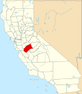
Bear Creek, Merced County, California
From Wikipedia, the free encyclopedia
Bear Creek | |
|---|---|
.jpg) | |
  Bear Creek Location in California | |
| Coordinates: 37°17′50″N 120°25′03″W / 37.29722°N 120.41750°W | |
| Country |  United States United States |
| State |  California California |
| County | Merced |
| Area | |
• Total | 0.058 sq mi (0.15 km2) |
| • Land | 0.058 sq mi (0.15 km2) |
| • Water | 0 sq mi (0.00 km2) 0% |
| Elevation | 190 ft (58 m) |
| Population | |
• Total | 273 |
| • Density | 4,764.3/sq mi (1,839.49/km2) |
| Time zone | UTC-8 (Pacific (PST)) |
| • Summer (DST) | UTC-7 (PDT) |
| ZIP Code | 95340 |
| Area code | 209 |
| FIPS Code | 06-04632 |
| GNIS feature ID | 1659692; 2629759 |
| U.S. Geological Survey Geographic Names Information System: Bear Creek, Merced County, California; U.S. Geological Survey Geographic Names Information System: Bear Creek, Merced County, California | |
Bear Creek is a census-designated place[4] in Merced County, California.[2] It is located 3.5 miles (5.6 km) east of Merced,[5] at an elevation of 190 feet (58 m).[2] The population was 273 at the 2020 United States census,[3] down from 290 at the 2010 census.
A post office operated at Bear Creek from 1871 to 1872.[6]