Bears, Friesland
Village in Friesland, Netherlands
From Wikipedia, the free encyclopedia
Bears (Dutch: Beers) is a small village in the Dutch province of Friesland.[3] It is located in the municipality Leeuwarden, about 8 km southwest of Leeuwarden.[4] Bears has a population of about 133 in January 2017.[5]

Beers
Bears | |
|---|---|
Village | |
St Mary's church | |
_vlag.svg) Flag  Coat of arms | |
 | |
 Bears in the former municipality of Littenseradiel | |
 Beers Location in the Netherlands  Beers Beers (Netherlands) | |
| Coordinates: 53°9′23″N 5°44′2″E | |
| Country | |
| Province | |
| Municipality | |
| Area | |
• Total | 2.46 km2 (0.95 sq mi) |
| Elevation | 2 m (6.6 ft) |
| Population (2021)[1] | |
• Total | 135 |
| • Density | 54.9/km2 (142/sq mi) |
| Time zone | UTC+1 (CET) |
| • Summer (DST) | UTC+2 (CEST) |
| Postal code | 9025[1] |
| Dialing code | 058 |
The official name of the village is in Frisian ("Bears"), like all villages in Littenseradiel. "Beers" is the Dutch name.
History
It was first mentioned in 1305 as Beerse, and means "fenced off hunting area".[6] Bears is a terp (artificial living hill) village. The Protestant church of Bears dates from the 13th century.[7] The Uniastate was a stins of the Unia family. The estate was demolished in 1756, and only the gate house has remained. A steel framed replica of the estate was built in the 1990, and has an observation tower in the middle to view the landscape.[8]
Before 2018, the village was part of the Littenseradiel municipality.[7]
Notable buildings
Gallery
 Sculpture of the former Uniastate
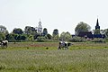 View on Bears
 Inside the Maria Church
 Gate house of Uniastate


