Boom Mountain
From Wikipedia, the free encyclopedia
| Boom Mountain | |
|---|---|
 Boom Mountain and Boom Lake | |
| Highest point | |
| Elevation | 2,760 m (9,060 ft)[1][2] |
| Prominence | 458 m (1,503 ft)[3] |
| Listing | |
| Coordinates | 51°15′03″N 116°04′43″W / 51.25083°N 116.07861°W[4] |
| Geography | |
 Boom Mountain Location in Alberta  Boom Mountain Location in British Columbia  Boom Mountain Location in Canada | |
| Country | Canada |
| Provinces | Alberta and British Columbia |
| Protected area | Banff National Park[5] |
| Parent range | |
| Topo map | NTS 82N8 Lake Louise[6] |
| Geology | |
| Rock age | Cambrian |
| Rock type | Sedimentary rock |
| Climbing | |
| First ascent | 1903 Dominion Survey Party[3][1] |
Boom Mountain is located north of Vermilion Pass and straddles the Continental Divide marking the Alberta-British Columbia border. It was named in 1908 after Boom Lake which is located right under the mountain.[1][3] When viewed by an Alpine Club of Canada expedition, a buildup of logs on the lake resembled a log boom.[7][8]
Boom Mountain is composed of sedimentary rock laid down from the Precambrian to Jurassic periods.[9] Formed in shallow seas, this sedimentary rock was pushed east and over the top of younger rock during the Laramide orogeny.[10]
Climate
Based on the Köppen climate classification, Boom Mountain is located in a subarctic climate with cold, snowy winters, and mild summers.[11] Temperatures can drop below −20 °C (−4 °F) with wind chill factors below −30 °C (−22 °F).
Gallery
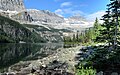 Boom Lake in Banff National Park. (A part of Boom Mountain in upper left corner of frame)
