Bornesketaig
From Wikipedia, the free encyclopedia
Human settlement in Scotland
Bornesketaig
| |
|---|---|
 | |
 Bornesketaig Location within the Isle of Skye | |
| OS grid reference | NG3771 |
| Council area | |
| Country | Scotland |
| Sovereign state | United Kingdom |
| Postcode district | IV51 9 |
| Police | Scotland |
| Fire | Scottish |
| Ambulance | Scottish |
| 57°39′N 6°25′W / 57.65°N 06.41°W / 57.65; -06.41 | |
Bornesketaig, Scottish Gaelic Borgh na Sgiotaig, is a dispersed crofting settlement in Trotternish on the Isle of Skye.[1][2]
Gallery
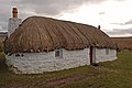 Beaton's Croft, 40 Bornesketaig, is a Category A listed building
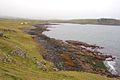 The beach of Camas Mor with some of the houses in Bornesketaig


References
- ↑ Ordnance Survey: Landranger map sheet 23 North Skye (Dunvegan & Portree) (Map). Ordnance Survey. 2011. ISBN 9780319229897.
- ↑ "Ordnance Survey: 1:50,000 Scale Gazetteer" (csv (download)). www.ordnancesurvey.co.uk. Ordnance Survey. 1 January 2016. Retrieved 30 January 2016.
Wikimedia Commons has media related to Bornesketaig.
This Skye and Lochalsh location article is a stub. You can help Wikipedia by expanding it. |