Bounoura
Commune and town in Ghardaïa Province, Algeria
From Wikipedia, the free encyclopedia
Bounoura (Arabic: بونورة, Berber: ⴰⵜ ⴱⵓⵏⵓⵔ, At-Bounour, البونور) is a town and commune in Ghardaïa Province, Algeria. According to the 2008 census it has a population of 35,405,[1] up from 27,775 in 1998,[2] with an annual growth rate of 2.5%.[1] It is effectively a suburb of the provincial capital Ghardaïa.

Bounoura
بونورة | |
|---|---|
Commune and town | |
Bounoura ksar. | |
 Location of Bounoura commune within Ghardaïa Province | |
 Bounoura Location of Bounoura within Algeria | |
| Coordinates: 32°28′57″N 3°42′13″E | |
| Country | |
| Province | Ghardaïa Province |
| District | Bounoura District |
| Elevation | 493 m (1,617 ft) |
| Population (2008)[1] | |
• Total | 35,405 |
| Time zone | UTC+1 (CET) |
Bounoura is also the name of one of the ksars of the pentapolis of the M'zab valley, constituting the commune of Bounoura.[3]
Geography
Bounoura lies on the banks of the Wadi Mzab, an intermittent river in the M'zab valley, just downstream upstream of Ghardaïa. The area has been listed as a UNESCO World Heritage Site.[4]
Transportation
Bounoura is located on the N1 highway, part of the Trans-Sahara Highway, which leads north to Laghouat and south to El Goléa, In Salah and Tamanrasset.
Education
Localities
In 1984, the commune of Bounoura is composed of five localities, including Beni Isguen ksar. [7] From the 1990s, new localities emerged to respond to the housing crisis. This is particularly the case of Tafilelt, Tinemmirine, Tawenza and Tinaâm attached to Bounoura, which were built according to the principles of ksourian architecture, and adapted to the proximity of the desert.[8][9]
- Bounoura historic ksar
- Beni Izguen from the new highschool and new C.E.M.
- Sidi Abbaz neighbourhood
- Bounoura palm grove
- Beni Isguen historic ksar
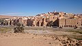 Bounoura ksar.
 Great mosque of Bounoura.
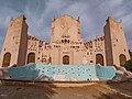 Bounoura roundabout, monument for Moufdi Zakaria.
 Beni Isguen ksar.
 Beni Isguen ksar from the sky.
 View of the new town Tafilelt.
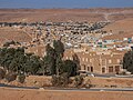 View of the new town of Tinemmirine, from the new town of Tafilelt.
 Tafilelt street.
 Boulila tower, mosque and 4-fingered iduden, Beni Isguen ksar.
 Beni Isguen ksar street.
 Market place, Beni Isguen ksar.


