Brunot, Missouri
From Wikipedia, the free encyclopedia
Brunot | |
|---|---|
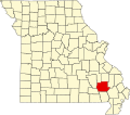
 Brunot Location within the state of Missouri | |
| Coordinates: 37°18′37″N 90°32′24″W / 37.31028°N 90.54000°W | |
| Country | United States |
| State | Missouri |
| County | Wayne |
| Elevation | 495 ft (151 m) |
| Time zone | UTC-6 (Central (CST)) |
| • Summer (DST) | UTC-5 (CDT) |
| ZIP codes | 63636 |
| Area code | 573 |
| GNIS feature ID | 730456[1] |
Brunot is an unincorporated community in the northwest corner of Wayne County, Missouri, United States.[1] It is located approximately six miles east of Des Arc on Route 143. The community is on the west bank of Crane Pond Creek.[2]