Bunker Hill, Mississippi
From Wikipedia, the free encyclopedia
Bunker Hill, Mississippi | |
|---|---|
 Bunker Hill  Bunker Hill | |
| Coordinates: 31°23′15″N 89°48′12″W / 31.38750°N 89.80333°W | |
| Country | United States |
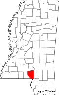
| State | Mississippi |
| County | Marion |
| Elevation | 325 ft (99 m) |
| Time zone | UTC-6 (Central (CST)) |
| • Summer (DST) | UTC-5 (CDT) |
| GNIS feature ID | 691737[1] |
Bunker Hill, (also known as Carley[2]), is an unincorporated community in Marion County located 9.3 miles (15.0 km) miles north-northeast of Columbia on Mississippi Highway 35.[1]
Bunker Hill was originally known as Carley and once had a masonic lodge, school, and two stores.[2] The community eventually became known as Bunker Hill. There are two theories as to where the name Bunker Hill originated: one theory says it is named for the large hill on which the community is located.[2] Another story tells that after the community was chosen as the site to open a new school in Marion County, the citizens felt they had worked as hard "as the men did to win the Battle of Bunker Hill".[3]
In 1900, Bunker Hill had a population of 32.[4]
A post office operated under the name Carley from 1880 to 1907.[5]