Concord (CDP), Vermont
From Wikipedia, the free encyclopedia
Concord, Vermont | |
|---|---|
 Concord, VT, from the east | |
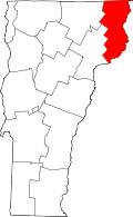
_highlighted.svg) Location in Essex County and the state of Vermont. | |
| Coordinates: 44°25′43″N 71°53′18″W / 44.42861°N 71.88833°W | |
| Country | United States |
| State | Vermont |
| County | Essex |
| Town | Concord |
| Area | |
• Total | 1.13 sq mi (2.92 km2) |
| • Land | 1.10 sq mi (2.85 km2) |
| • Water | 0.027 sq mi (0.07 km2) |
| Elevation | 880 ft (270 m) |
| Population | |
• Total | 271 |
| • Density | 247/sq mi (95.2/km2) |
| Time zone | UTC-5 (Eastern (EST)) |
| • Summer (DST) | UTC-4 (EDT) |
| ZIP code | 05824[2] |
| Area code | 802 |
| GNIS feature ID | 1456992[3] |
| FIPS code | 50-15175 |
Concord is a census-designated place comprising the main settlement in the town of Concord, Essex County, Vermont, United States. As of the 2020 census, it had a population of 213,[1]. The Concord CDP is in the western part of the town of Concord, along the Moose River, a west-flowing tributary of the Passumpsic River and part of the Connecticut River basin. U.S. Route 2 passes through the center of the CDP, leading west 8 miles (13 km) to St. Johnsbury and east 20 miles (32 km) to Lancaster, New Hampshire.
The Concord CDP has a total area of 1.1 square miles (2.9 km2), of which 0.027 square miles (0.07 km2), or 2.50%, is water.[1]