Daretown, New Jersey
From Wikipedia, the free encyclopedia
Country United States
Elevation135 ft (41 m)
Daretown, New Jersey | |
|---|---|
 Wide view of Daretown from Newkirk Station Road | |
 Daretown, New Jersey  Daretown, New Jersey  Daretown, New Jersey | |
| Coordinates: 39°36′15″N 75°15′27″W / 39.60417°N 75.25750°W | |
| Country | |
| State | |
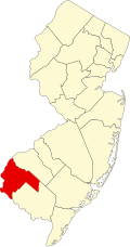
| County | Salem |
| Township | Upper Pittsgrove |
| Named after | Samuel Dare |
| Elevation | 135 ft (41 m) |
| Time zone | UTC−05:00 (Eastern (EST)) |
| • Summer (DST) | UTC−04:00 (EDT) |
| GNIS feature ID | 875799[1] |
Daretown is an unincorporated community within Upper Pittsgrove Township in Salem County, in the U.S. state of New Jersey.[1][2][3]
Alloway Creek flows south of Daretown, while the Salem River flows to the north.