De Tonti Square Historic District
Historic district in Alabama, United States
From Wikipedia, the free encyclopedia
The De Tonti Square Historic District is a historic district in the city of Mobile, Alabama, United States. It was placed on the National Register of Historic Places on February 7, 1972.[1] It is a nine-block area, roughly bounded by Adams, St. Anthony, Claiborne, and Conception Streets. The district covers 28 acres (0.11 km2) and contains 66 contributing buildings. It was named in honor of Henri de Tonti and consists mainly of townhouses built between 1840 and 1860. It includes numerous examples of the Federal, Greek Revival, and Italianate architectural styles.[2]

LocationRoughly bounded by Adams, St. Anthony, Claiborne, and Conception Sts., Mobile, Alabama
Coordinates30°41′44″N 88°2′48″W
Area28 acres (11 ha)
ArchitecturalstyleClassical Revival, Late Victorian, Federal
De Tonti Square Historic District | |
| |
  Location within Mobile, Alabama  Location within Alabama  Location within the United States | |
| Location | Roughly bounded by Adams, St. Anthony, Claiborne, and Conception Sts., Mobile, Alabama |
|---|---|
| Coordinates | 30°41′44″N 88°2′48″W |
| Area | 28 acres (11 ha) |
| Architectural style | Classical Revival, Late Victorian, Federal |
| NRHP reference No. | 72000169[1] |
| Added to NRHP | February 7, 1972 |
Gallery
 The Richards DAR House at 256 Joachim Street
 Williams-Rogers House at 250 St. Anthony Street
 258 State Street
 254 St. Anthony Street
 256 State Street
 261 Joachim Street
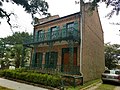 251 St. Anthony Street - September 2017
 251 & 253 St. Anthony Street - September 2017


