Dewmaine, Illinois
From Wikipedia, the free encyclopedia
Dewmaine, Illinois | |
|---|---|
  Dewmaine, Illinois  Dewmaine, Illinois | |
| Coordinates: 37°46′50″N 89°04′37″W / 37.78056°N 89.07694°W | |
| Country | United States |
| State | Illinois |
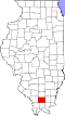
| County | Williamson |
| Elevation | 430 ft (130 m) |
| Time zone | UTC-6 (Central (CST)) |
| • Summer (DST) | UTC-5 (CDT) |
| ZIP Code | 62918 |
| Area code | 618 |
| GNIS feature ID | 407173[1] |
Dewmaine was an unincorporated African-American coal-mining community in Williamson County, Illinois. Today the area is almost completely non-residential and vacant land, though it now sits at the northern edge of Carterville. Its name is an amalgamation of Admiral Dewey and the USS Maine from the Spanish–American War.[2]
A post office was established at Dewmaine in 1901, and remained in operation until 1931.[3] It is now served by the Carterville post office. Estimated population in 1958 was 50.[4]
A school, two churches, and several stores existed in the town. The school was open from 1910-1929.[5]
Dewmaine was located a mile north of Carterville on the Carterville—Colp Road.