Dobongsan
Mountain in South Korea
From Wikipedia, the free encyclopedia
Dobongsan (Korean: 도봉산) is a mountain in Bukhansan National Park, South Korea.[1] It extends across Seoul, the national capital, and the cities of Yangju and Uijeongbu, in the province of Gyeonggi Province.[2] It has an elevation of 739.5 m (2,426 ft).[3] Nearby Dobongsan Station is named after it.[4]
,_Manjangbong_(718m),_Jaunbong_(740m)_and_Shinseondae_(730m).JPG)
| Dobongsan | |
|---|---|
Mount Dobongsan peaks Seoninbong (708 m), Manjangbong (718 m), Jaunbong (740 m) and Shinseondae (730 m) taken from trail leading to summit. | |
| Highest point | |
| Elevation | 739.5 m (2,426 ft) |
| Coordinates | 37°41′54.73″N 127°0′53.88″E |
| Geography | |
 | |
| Location | Bukhansan National Park, South Korea |
| Climbing | |
| Easiest route | Dobongsan Station |
| Korean name | |
| Hangul | 도봉산 |
| Hanja | 道峰山 |
| RR | Dobongsan |
| MR | Tobongsan |
It is known for the magnificent rock formations of the Manjangbong, Seoninbong, Jubong, Obong and Uiambong Peaks. The Seoninbong summit has 37 hiking courses connecting to it, including the famous Bakjwi (Bat) Course. The mountain is also home to Cheonchuksa Buddhist Temple, the oldest temple in the region, and several other temples including Mangwolsa, Wonhyosa and Hoeryongsa, as well as a number of beautiful valleys called Donong, Songchu, Obong and Yeongeocheon. Furthermore, it is easily accessible by public transportation.[5]
Hiking course
Gallery
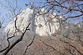 East face of Seoninbong Peak, Dobongsan taken from the trail leading to Manworam Temple.
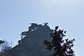 Observation area on a peak of Dobongsan.
 Rugged trail leading to peak of Dobongsan.
 Wartime bunker on Dobongsan summit trail in Korea.
 Petroglyph in stream bed at the foot of Dobongsan.
 Temple on Dobongsan
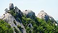 Obong
Obong


