Dorset Avenue Bridge
From Wikipedia, the free encyclopedia
Dorset Avenue Bridge | |
|---|---|
 | |
| Coordinates | 39°20′30″N 74°28′42″W / 39.34167°N 74.47833°W |
| Carries | CR 629 |
| Crosses | Inner Thorofare Intracoastal Waterway |
| Locale | Ventnor City New Jersey |
| Maintained by | Atlantic County |
| ID number | 01V0001[1] |
| Characteristics | |
| Design | Strauss bascule |
| Material | Steel/concrete |
| Total length | 220.2 ft (67.1 m) |
| Width | 36.1 ft (11.0 m) (deck) 16 ft (4.9 m) (sidewalks) |
| Longest span | 79.1 ft (24.1 m) |
| No. of spans | 3 |
| Clearance below | 9 ft (2.7 m)[2][3] |
| History | |
| Designer | A.H. Nelson |
| Opened | 1929 |
| Location | |
 | |
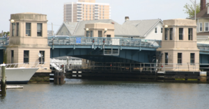
The Dorset Avenue Bridge is a vehicular bridge in Ventnor City, Atlantic County, New Jersey, south of in Atlantic City. The double-leaf Strauss trunnion bascule drawbridge spans the Intracoastal Waterway (ICW) Inside Thorofare (MP 72.1) and carries CR 629 (MP 3.2) in Ventnor Heights and St Leonard's Tract on Absecon Island.