Doyle Road Covered Bridge
From Wikipedia, the free encyclopedia
LocaleAshtabula County, Ohio, United States
Designsingle span, Town truss
Total length94 feet (28.7 m)
Doyle Road Bridge | |
|---|---|
_Covered_Bridge_1.jpg) | |
| Coordinates | 41°45′44″N 80°47′25″W / 41.76222°N 80.79028°W |
| Locale | Ashtabula County, Ohio, United States |
| Characteristics | |
| Design | single span, Town truss |
| Total length | 94 feet (28.7 m) |
| History | |
| Construction start | 1868 |
| Location | |
 | |
Doyle Road Bridge is a covered bridge spanning Mill Creek in Jefferson Township, Ashtabula County, Ohio, United States. The bridge, one of 16 drivable bridges in the county, is a single span Town truss design, with laminated arches added during its renovation in 1987.[1] The bridge’s WGCB number is 35-04-16,[2] and it is located approximately 1.9 mi (3.1 km) north-northwest of Jefferson.
Dimensions
- Length: 94 feet (29 m)
- Overhead clearance: 13 feet 3 inches (4.04 m)
Photo
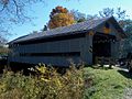 View from northeast

_Covered_Bridge_2.jpg)
.jpg)
.jpg)