Dugandan railway line
Railway line in Queensland, Australia
From Wikipedia, the free encyclopedia
The Dugandan railway line was a branch railway in the Scenic Rim region of South East Queensland, Australia. It was also known as the Fassifern railway line. It operated from 1882 to 1964.[1]

Churchill branch railway
| Dugandan railway line | |||||||||||||||||||||||||||||||||||||||||||||||||||||||||||||||||||||||||||||||||||||||||||||||||||||||||||||||||||||||||||||||||||||||||||||||||||||||||||||||||||||||||||||||||||||||||||||||||||||||||||||||||||||||||||||||||
|---|---|---|---|---|---|---|---|---|---|---|---|---|---|---|---|---|---|---|---|---|---|---|---|---|---|---|---|---|---|---|---|---|---|---|---|---|---|---|---|---|---|---|---|---|---|---|---|---|---|---|---|---|---|---|---|---|---|---|---|---|---|---|---|---|---|---|---|---|---|---|---|---|---|---|---|---|---|---|---|---|---|---|---|---|---|---|---|---|---|---|---|---|---|---|---|---|---|---|---|---|---|---|---|---|---|---|---|---|---|---|---|---|---|---|---|---|---|---|---|---|---|---|---|---|---|---|---|---|---|---|---|---|---|---|---|---|---|---|---|---|---|---|---|---|---|---|---|---|---|---|---|---|---|---|---|---|---|---|---|---|---|---|---|---|---|---|---|---|---|---|---|---|---|---|---|---|---|---|---|---|---|---|---|---|---|---|---|---|---|---|---|---|---|---|---|---|---|---|---|---|---|---|---|---|---|---|---|---|---|---|---|---|---|---|---|---|---|---|---|---|---|---|---|---|---|
Dugandan Railway Station, near Boonah, circa 1930 | |||||||||||||||||||||||||||||||||||||||||||||||||||||||||||||||||||||||||||||||||||||||||||||||||||||||||||||||||||||||||||||||||||||||||||||||||||||||||||||||||||||||||||||||||||||||||||||||||||||||||||||||||||||||||||||||||
| Overview | |||||||||||||||||||||||||||||||||||||||||||||||||||||||||||||||||||||||||||||||||||||||||||||||||||||||||||||||||||||||||||||||||||||||||||||||||||||||||||||||||||||||||||||||||||||||||||||||||||||||||||||||||||||||||||||||||
| Other names | Fassifern railway line Churchill branch railway | ||||||||||||||||||||||||||||||||||||||||||||||||||||||||||||||||||||||||||||||||||||||||||||||||||||||||||||||||||||||||||||||||||||||||||||||||||||||||||||||||||||||||||||||||||||||||||||||||||||||||||||||||||||||||||||||||
| Locale | Queensland, Australia | ||||||||||||||||||||||||||||||||||||||||||||||||||||||||||||||||||||||||||||||||||||||||||||||||||||||||||||||||||||||||||||||||||||||||||||||||||||||||||||||||||||||||||||||||||||||||||||||||||||||||||||||||||||||||||||||||
| History | |||||||||||||||||||||||||||||||||||||||||||||||||||||||||||||||||||||||||||||||||||||||||||||||||||||||||||||||||||||||||||||||||||||||||||||||||||||||||||||||||||||||||||||||||||||||||||||||||||||||||||||||||||||||||||||||||
| Opened | 1882 | ||||||||||||||||||||||||||||||||||||||||||||||||||||||||||||||||||||||||||||||||||||||||||||||||||||||||||||||||||||||||||||||||||||||||||||||||||||||||||||||||||||||||||||||||||||||||||||||||||||||||||||||||||||||||||||||||
| Closed | 1964 | ||||||||||||||||||||||||||||||||||||||||||||||||||||||||||||||||||||||||||||||||||||||||||||||||||||||||||||||||||||||||||||||||||||||||||||||||||||||||||||||||||||||||||||||||||||||||||||||||||||||||||||||||||||||||||||||||
| Technical | |||||||||||||||||||||||||||||||||||||||||||||||||||||||||||||||||||||||||||||||||||||||||||||||||||||||||||||||||||||||||||||||||||||||||||||||||||||||||||||||||||||||||||||||||||||||||||||||||||||||||||||||||||||||||||||||||
| Line length | 35 miles 28 chains (56.9 km) | ||||||||||||||||||||||||||||||||||||||||||||||||||||||||||||||||||||||||||||||||||||||||||||||||||||||||||||||||||||||||||||||||||||||||||||||||||||||||||||||||||||||||||||||||||||||||||||||||||||||||||||||||||||||||||||||||
| |||||||||||||||||||||||||||||||||||||||||||||||||||||||||||||||||||||||||||||||||||||||||||||||||||||||||||||||||||||||||||||||||||||||||||||||||||||||||||||||||||||||||||||||||||||||||||||||||||||||||||||||||||||||||||||||||


Geography
The line began west of Ipswich station on the Main Line 39 km west of Brisbane and proceeded generally southward for approximately 50 km to the locality of Dugandan now part of the urban settlement of Boonah.
History
Residents in the Fassifern Valley petitioned the Queensland Government to build a railway line to their district, and the first section was opened on 10 July 1882 as far as Harrisville. This is considered to be Queensland's first branch railway. The branch was extended to Dugandan on 12 September 1887.[1][2]
The Mount Edwards branch line branched off the Dugandan line at Munbilla. The Mount Edwards line opened to Kalbar on 17 April 1916 and to Mount Edwards on 7 October 1922. The Mount Edwards line closed in 1960.[3][4]
During its life, the Dugandan branch carried mixed traffic, including goods trains, mixed trains and rail motors.[2]
The Dugandan branch was closed beyond the Churchill railway station on 30 June 1964 due to increasing competition from road transport.[2][5] The small remaining section was known as the Churchill branch railway.[6]
Route
| Distance | Name | Coordinates | Altitude | Notes |
|---|---|---|---|---|
| 24 miles 07 chains (38.8 km) from Brisbane, 0 miles 0 chains (0 km) from Ipswich | Ipswich railway station | 27.6131°S 152.7606°E | 62 feet (19 m) | [7][8] |
| Fassifern Junction where the Dugandan line splits from the Main Line railway | 27.61551°S 152.74947°E | [7] | ||
| 1 km from Ipswich | Shillito & Sons siding | |||
| 1 km from Ipswich | Spanns siding | |||
| 25 miles 31 chains (40.9 km) from Brisbane | Little Ipswich railway station | 27.6216°S 152.7504°E | 97 feet (30 m) | [7][9][10] |
| 2 km from Ipswich | Noble Vale No 6. Colliery siding | |||
| 3 km from Ipswich | Cattle siding | |||
| 26 miles 21 chains (42.3 km) from Brisbane | Churchill railway station | 27.6356°S 152.7486°E | 77 feet (23 m) | [7][11] |
| 29 miles 28 chains (47.2 km) from Brisbane | Loamside railway station | 27.6711°S 152.7364°E | 155 feet (47 m) | [7] |
| 13 miles 78 chains (22.5 km) from Brisbane | Hampstead railway station | 27.69364°S 152.73846°E | 118 feet (36 m) | [7] |
| 32 miles 14 chains (51.8 km) from Brisbane | Purga railway station | 27.71008°S 152.73864°E | 162 feet (49 m) | [7] |
| 34 miles 0 chains (54.7 km) from Brisbane | Goolman railway station | 27.7365°S 152.7416°E | 137 feet (42 m) | [7] |
| 34 miles 74 chains (56.2 km) from Brisbane, 10 miles 57 chains (17.2 km) from Ipswich | Hillside railway station | 27.7497°S 152.7367°E | 154 feet (47 m) | [12][13][7] |
| 11 miles 687 chains (31.5 km) from Ipswich | Rockton railway station | 27.7639°S 152.7380°E | 155 feet (47 m) | [12][13] |
| 12 miles 73 chains (20.8 km) from Ipswich | Peak Crossing railway station | 27.7770°S 152.7336°E | 165 feet (50 m) | [12][13] |
| 13 miles 72 chains (22.4 km) from Ipswich | Flinders railway station | 27.7886°S 152.7217°E | 247 feet (75 m) | [12][13] |
| 15 miles 77 chains (25.7 km) from Ipswich | Churchbank railway station | 27.7891°S 152.6916°E | 155 feet (47 m) | [12][13] |
| 18 miles 50 chains (30.0 km) from Ipswich | Harrisville railway station | 27.8110°S 152.6666°E | 179 feet (55 m) | [12][13] |
| 20 miles 54 chains (33.3 km) from Ipswich | Wilsons Plains railway station | 27.8362°S 152.6556°E | 188 feet (57 m) | [12][13] |
| 22 miles 09 chains (35.6 km) from Ipswich | Radford railway station | 27.8541°S 152.6437°E | 194 feet (59 m) | [12][13] |
| 23 miles 64 chains (38.3 km) from Ipswich | Munbilla railway station | 27.8711°S 152.6561°E | 278 feet (85 m) | [12][13] |
| Junction with Mount Edwards railway line | 27.8714°S 152.6563°E | [12] | ||
| 25 miles 12 chains (40.5 km) from Ipswich | Anthony railway station | 27.8836°S 152.6731°E | 398 feet (121 m) | [12][13] |
| 27 miles 14 chains (43.7 km) from Ipswich | Blantyre railway station | 27.9056°S 152.6832°E | 543 feet (166 m) | [12][13] |
| 28 miles 05 chains (45.2 km) from Ipswich | Roadvale railway station | 27.9164°S 152.6839°E | 554 feet (169 m) | [12][13] |
| 29 miles 07 chains (46.8 km) from Ipswich | Kulgun railway station | 27.9314°S 152.6831°E | 570 feet (170 m) | [12][13] |
| 30 miles 41 chains (49.1 km) from Ipswich | Teviotville railway station | 27.9472°S 152.6867°E | 600 feet (180 m) | [12][13] |
| 32 miles 45 chains (52.4 km) from Ipswich | Hoya railway station | 27.9706°S 152.6891°E | 427 feet (130 m) | [12][13] |
| 34 miles 65 chains (56.0 km) from Ipswich | Boonah railway station | 27.9969°S 152.6816°E | 332 feet (101 m) | [12][13] |
| 35 miles 28 chains (56.9 km) from Ipswich | Dugandan railway station | 28.0039°S 152.6777°E | 299 feet (91 m) | [14][15][13] |
Legacy

There is a memorial to the railway line in Yeates Street, Boonah at the back of the Commercial Hotel (27.99714°S 152.68176°E). The memorial is on the site of the former Boonah railway station.[16]
Some evidence of the line's existence remains today. An embankment which carried the railway over a floodplain immediately north of Boonah is still readily visible from the Boonah-Fassifern Road. The station building at Harrisville is still intact, as is a small cutting immediately south of Harrisville station. Part of the alignment between Boonah and Dugandan along a cut-and-fill embankment is now a paved footpath through an urban park.
As of 2009, the Scenic Rim Region is developing a rail trail in partnership with the Queensland state government. The trail for the use of bushwalkers, cyclists and horse riders will follow some of the former alignment between Ipswich and Boonah.[17]
Gallery
 Harrisville railway station
 Shallow railway cutting in Harrisville
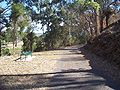 Former track formation between Boonah and Dugandan with a cutting on the right, now a footpath through a park


