Dunlop Parish (Yanda County)
From Wikipedia, the free encyclopedia
Dunlop Parish | |
|---|---|
 | |
 Dunlop Parish | |
| Coordinates: 30°32′0″S 145°07′0″E / 30.53333°S 145.11667°E | |
| Country | Australia |
| State | New South Wales |
| LGA | |
| Government | |
| • State electorate | |
| • Federal division | |
| Elevation | 100 m (330 ft) |
| Postcode | 2840 |
Dunlop Parish is a civil parish,[1] of Yanda County, a cadasteral division of New South Wales;[2] a Cadastral division of New South Wales.[3][4][5][6]
The Parish is on the Darling River upstream of Wilcannia, New South Wales[7][8] and down stream of Bourke, New South Wales.
The only town of the parish is Louth, New South Wales.
Geography
The topography is flat with a Köppen climate classification of BsK (Hot semi arid).[9]
The economy in the parish is based on broad acre agriculture, mainly Wheat, and sheep.
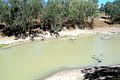 Darling River Dunlop Parish
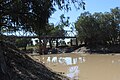 Louth bridge 1.JPG Dunlop Parish
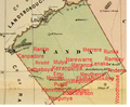


_Australia.png)
The Dunlop Ranges are in the parish.