Elizaville, Kentucky
From Wikipedia, the free encyclopedia
Elizaville, Kentucky | |
|---|---|
 The former Elizaville Presbyterian Church | |
 Elizaville | |
| Coordinates: 38°25′00″N 83°49′27″W / 38.41667°N 83.82417°W | |
| Country | United States |
| State | Kentucky |
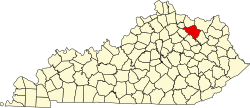
| County | Fleming |
| Area | |
• Total | 1.03 sq mi (2.66 km2) |
| • Land | 1.03 sq mi (2.66 km2) |
| • Water | 0.0039 sq mi (0.01 km2) |
| Elevation | 922 ft (281 m) |
| Population (2020) | |
• Total | 190 |
| • Density | 185.2/sq mi (71.49/km2) |
| Time zone | UTC-5 (Eastern (EST)) |
| • Summer (DST) | UTC-4 (EDT) |
| ZIP code | 41037 |
| Area code | 606 |
| GNIS feature ID | 2629608[2] |
Elizaville is a census-designated place and unincorporated community in Fleming County, Kentucky, United States. As of the 2020 census, Elizaville had a population of 190.[3] Elizaville is located at the junction of Kentucky Route 32 and Kentucky Route 170, 5 miles (8.0 km) west of Flemingsburg.[4] Elizaville has a post office with ZIP code 41037.[5][6]