Embreeville, Tennessee
From Wikipedia, the free encyclopedia
Embreeville | |
|---|---|
 Embreeville  Embreeville | |
| Coordinates: 36°10′52″N 82°27′31″W / 36.18111°N 82.45861°W | |
| Country | United States |
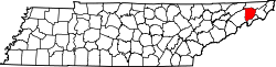
| State | Tennessee |
| Counties | Washington |
| Area | |
• Total | 1.43 sq mi (3.70 km2) |
| • Land | 1.34 sq mi (3.48 km2) |
| • Water | 0.085 sq mi (0.22 km2) |
| Elevation | 1,598 ft (487 m) |
| Population | |
• Total | 429 |
| • Density | 319.3/sq mi (123.27/km2) |
| Time zone | UTC-5 (Eastern (EST)) |
| • Summer (DST) | UTC-4 (EDT) |
| ZIP code | 37650 |
| Area code | 423 |
| GNIS feature ID | 47-23880 |
Embreeville is an unincorporated community and census-designated place in southern Washington County, Tennessee.[3] It is located along the Nolichucky River and on State Routes 81 and 107.
The population of the CDP was 429 at the 2020 census.[4]