Erskine, Oregon
From Wikipedia, the free encyclopedia
Erskine, Oregon | |
|---|---|
 Erskine, Oregon  Erskine, Oregon | |
| Coordinates: 45°26′17″N 120°46′43″W / 45.43806°N 120.77861°W | |
| Country | United States |
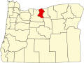
| State | Oregon |
| County | Sherman |
| Elevation | 2,162 ft (659 m) |
| Time zone | UTC-8 (Pacific (PST)) |
| • Summer (DST) | UTC-7 (PDT) |
| Area codes | 458 and 541 |
| GNIS feature ID | 1167703[1] |
Erskine is an unincorporated community in Sherman County, in the U.S. state of Oregon.[1] It lies between Moro and Grass Valley along Erskine Road, west of U.S. Route 97.[2][3]
Erskine at various times was known by other names: Erskineville, Erskine Springs, and Millra.[4] An Erskineville post office was established here in 1882; Abiel Erskine was the first postmaster.[4] The Columbia Southern Railway called the place Erskineville in 1900 when it built its line through this community, but the Union Pacific later shortened that to Erskine.[4] The Erskineville post office closed in 1907.[4] Erskine is the name that appears on maps in the 21st century.[2]