Erstein
From Wikipedia, the free encyclopedia
Erstein
Eerstain | |
|---|---|
 The town hall in Erstein | |
 Coat of arms | |
 Location of Erstein | |
 Erstein  Erstein | |
| Coordinates: 48°25′N 7°40′E / 48.42°N 7.66°E | |
| Country | France |
| Region | Grand Est |
| Department | Bas-Rhin |
| Arrondissement | Sélestat-Erstein |
| Canton | Erstein |
| Intercommunality | CC Canton d'Erstein |
| Government | |
| • Mayor (2022–2026) | Benoît Dintrich[1] |
Area 1 | 36.22 km2 (13.98 sq mi) |
| Population (2023)[2] | 10,790 |
| • Density | 297.9/km2 (771.6/sq mi) |
| Time zone | UTC+01:00 (CET) |
| • Summer (DST) | UTC+02:00 (CEST) |
| INSEE/Postal code | 67130 /67150 |
| Elevation | 147–157 m (482–515 ft) (avg. 150 m or 490 ft) |
| 1 French Land Register data, which excludes lakes, ponds, glaciers > 1 km2 (0.386 sq mi or 247 acres) and river estuaries. | |
Erstein (German pronunciation: [ɛɐ̯ˈʃtaɪ̯n], French: [ɛʁʃtajn] ⓘ; Alemannic: Eerstain) is a commune in the Bas-Rhin department, in the region of Grand Est, France.[3]
An important necropolis from the Merovingian era (6th-7th century) has been excavated near Erstein in 1999–2000.[4]
Erstein was known in Alsace in the Middle Age for its canonesses monastery, founded in the 9th century and abandoned in 1422. The buildings were destroyed in the 16th and 19th centuries.[5]
Demographics
Historical population | ||||||||||||||||||||||||||||||||||||||||||||||||||||||||||||||||||||||||||||||||||||||||||||||||||||||||||||||||||||||
|
| |||||||||||||||||||||||||||||||||||||||||||||||||||||||||||||||||||||||||||||||||||||||||||||||||||||||||||||||||||||
| Source: EHESS[6] and INSEE (1968-2023)[7] | ||||||||||||||||||||||||||||||||||||||||||||||||||||||||||||||||||||||||||||||||||||||||||||||||||||||||||||||||||||||
Twin towns
 Erstein Street
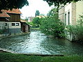 Near Ill River
 Calvaire (1746)
 Old Factory


