Ferndale, Oregon
From Wikipedia, the free encyclopedia
Ferndale, Oregon | |
|---|---|
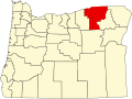
 Ferndale, Oregon Location within the state of Oregon | |
| Coordinates: 45°58′52″N 118°23′51″W / 45.98111°N 118.39750°W | |
| Country | United States |
| State | Oregon |
| County | Umatilla |
| Elevation | 843 ft (257 m) |
| Time zone | UTC-8 (Pacific (PST)) |
| • Summer (DST) | UTC-7 (PDT) |
| Area codes | 458 and 541 |
| GNIS feature ID | 1136284[1] |
Ferndale is an unincorporated community in Umatilla County, Oregon, United States.[1] It is near the Oregon–Washington border east of Oregon Route 339 and west of Oregon Route 11 about 4 miles (6 km) north of Milton-Freewater.[2]
Ferndale was once a station on the Walla Walla Valley Railway, which served the local fruit orchards, and the site of a fruit-packing warehouse.[3][4] The next station south on the line was at Sunnyside.[3] Ferndale Elementary School is part of the Milton-Freewater Unified School District.[5]